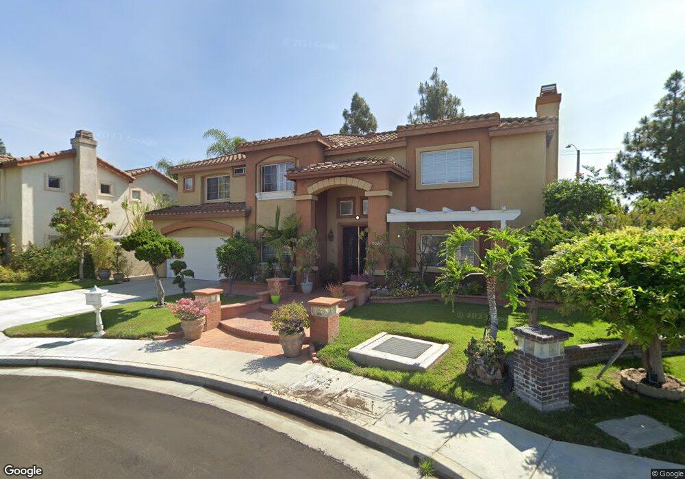
2020 S Nevis Ct Anaheim, CA 92802
Hermosa Village NeighborhoodEstimated Value: $1,255,000 - $1,384,000
4
Beds
3
Baths
2,450
Sq Ft
$531/Sq Ft
Est. Value
About This Home
This home is located at 2020 S Nevis Ct, Anaheim, CA 92802 and is currently estimated at $1,301,490, approximately $531 per square foot. 2020 S Nevis Ct is a home located in Orange County with nearby schools including Alexander J. Stoddard Elementary School, Ball Junior High School, and Loara High School.
Ownership History
Date
Name
Owned For
Owner Type
Purchase Details
Closed on
Jun 30, 2016
Sold by
Hoang Trang Teri and Chu Thang T
Bought by
Chu Thang T and Hoang Trang Teri
Current Estimated Value
Purchase Details
Closed on
Jan 10, 2002
Sold by
Hoang Tai and Hoang Alan Dong
Bought by
Hoang Trang Teri
Purchase Details
Closed on
Jun 28, 1999
Sold by
Pacific Anaheim
Bought by
Hoang Alan Dong and Nguyen Julie Phuc
Home Financials for this Owner
Home Financials are based on the most recent Mortgage that was taken out on this home.
Original Mortgage
$259,600
Interest Rate
6%
Create a Home Valuation Report for This Property
The Home Valuation Report is an in-depth analysis detailing your home's value as well as a comparison with similar homes in the area
Home Values in the Area
Average Home Value in this Area
Purchase History
| Date | Buyer | Sale Price | Title Company |
|---|---|---|---|
| Chu Thang T | -- | None Available | |
| Hoang Trang Teri | -- | -- | |
| Hoang Alan Dong | $324,500 | Chicago Title Co |
Source: Public Records
Mortgage History
| Date | Status | Borrower | Loan Amount |
|---|---|---|---|
| Previous Owner | Hoang Alan Dong | $259,600 |
Source: Public Records
Tax History Compared to Growth
Tax History
| Year | Tax Paid | Tax Assessment Tax Assessment Total Assessment is a certain percentage of the fair market value that is determined by local assessors to be the total taxable value of land and additions on the property. | Land | Improvement |
|---|---|---|---|---|
| 2025 | $6,599 | $576,135 | $242,215 | $333,920 |
| 2024 | $6,599 | $564,839 | $237,466 | $327,373 |
| 2023 | $6,461 | $553,764 | $232,810 | $320,954 |
| 2022 | $6,382 | $542,906 | $228,245 | $314,661 |
| 2021 | $6,394 | $532,261 | $223,769 | $308,492 |
| 2020 | $6,369 | $526,804 | $221,475 | $305,329 |
| 2019 | $6,176 | $516,475 | $217,132 | $299,343 |
| 2018 | $6,048 | $506,349 | $212,875 | $293,474 |
| 2017 | $5,808 | $496,421 | $208,701 | $287,720 |
| 2016 | $5,793 | $486,688 | $204,609 | $282,079 |
| 2015 | $5,743 | $479,378 | $201,536 | $277,842 |
| 2014 | $5,385 | $469,988 | $197,588 | $272,400 |
Source: Public Records
Map
Nearby Homes
- 1913 S Norma Ln
- 1838 S Ninth St
- 1828 S Ninth St
- 1640 W Ricky Ave
- 11401 Kathy Ln
- 1754 S Norfolk Ln
- 11531 Kathy Ln
- 11402 Morgan Ln
- 11531 West St
- 1419 W Laster Ave
- 1660 W Sallie Ln
- 11301 Euclid St Unit 121
- 11301 Euclid St Unit 21
- 11301 Euclid St Unit 109
- 11301 Euclid St Unit 60
- 10802 Palma Vista Ave
- 1616 S Euclid St Unit 54
- 1616 S Euclid St Unit 23
- 1616 S Euclid St Unit 75
- 1616 S Euclid St Unit 100
- 2030 S Nevis Ct
- 2010 S Nevis Ct
- 2035 S Nevis Ct
- 2015 S Nevis Ct
- 2025 S Nevis Ct
- 2005 S Nevis Ct
- 2002 S Ninth St
- 2006 S Ninth St
- 2019 S Ninth St
- 2012 S Ninth St
- 2010 S Waverly Dr
- 1932 S Ninth St
- 2008 S Waverly Dr
- 2012 S Waverly Dr
- 2018 S Ninth St
- 1501 W Wakefield Ave
- 1505 W Wakefield Ave
- 2004 S Waverly Dr
- 2014 S Waverly Dr
- 1509 W Wakefield Ave