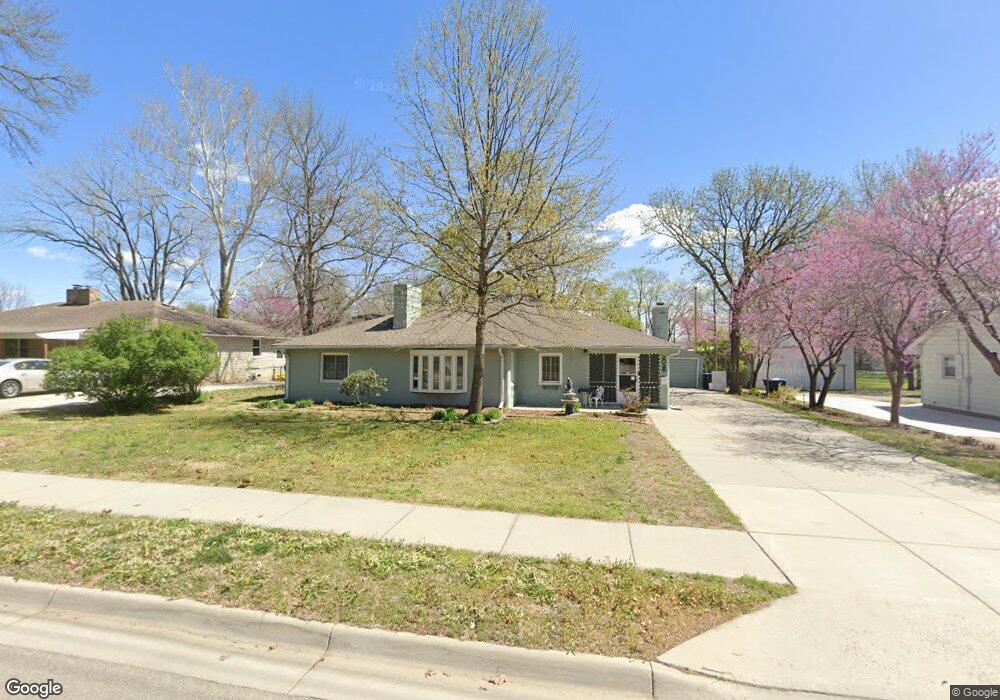
2020 SW Hope St Topeka, KS 66604
West Topeka NeighborhoodEstimated Value: $198,000 - $244,000
3
Beds
2
Baths
2,355
Sq Ft
$90/Sq Ft
Est. Value
About This Home
This home is located at 2020 SW Hope St, Topeka, KS 66604 and is currently estimated at $212,789, approximately $90 per square foot. 2020 SW Hope St is a home located in Shawnee County with nearby schools including Whitson Elementary School, Marjorie French Middle School, and Topeka West High School.
Ownership History
Date
Name
Owned For
Owner Type
Purchase Details
Closed on
Sep 7, 2021
Sold by
Lang Paul T and Lang Monica C
Bought by
Lang Paul T and Lang Monica C
Current Estimated Value
Home Financials for this Owner
Home Financials are based on the most recent Mortgage that was taken out on this home.
Original Mortgage
$175,500
Outstanding Balance
$159,692
Interest Rate
2.8%
Mortgage Type
VA
Estimated Equity
$53,097
Purchase Details
Closed on
Oct 28, 2016
Sold by
Lang Paul T and Lang Monica C
Bought by
Lang Paul T and Lang Monica C
Home Financials for this Owner
Home Financials are based on the most recent Mortgage that was taken out on this home.
Original Mortgage
$134,806
Interest Rate
3.42%
Mortgage Type
VA
Create a Home Valuation Report for This Property
The Home Valuation Report is an in-depth analysis detailing your home's value as well as a comparison with similar homes in the area
Home Values in the Area
Average Home Value in this Area
Purchase History
| Date | Buyer | Sale Price | Title Company |
|---|---|---|---|
| Lang Paul T | -- | Amrock Llc | |
| Lang Paul T | -- | New Title Company Name | |
| Lang Paul T | -- | Tsi Recording Department | |
| Lang Paul T | -- | Tsi Recording Department |
Source: Public Records
Mortgage History
| Date | Status | Borrower | Loan Amount |
|---|---|---|---|
| Open | Lang Paul T | $175,500 | |
| Previous Owner | Lang Paul T | $134,806 |
Source: Public Records
Tax History Compared to Growth
Tax History
| Year | Tax Paid | Tax Assessment Tax Assessment Total Assessment is a certain percentage of the fair market value that is determined by local assessors to be the total taxable value of land and additions on the property. | Land | Improvement |
|---|---|---|---|---|
| 2025 | $2,600 | $19,179 | -- | -- |
| 2023 | $2,600 | $17,403 | $0 | $0 |
| 2022 | $2,248 | $15,132 | $0 | $0 |
| 2021 | $2,060 | $13,159 | $0 | $0 |
| 2020 | $1,938 | $12,532 | $0 | $0 |
| 2019 | $1,911 | $12,286 | $0 | $0 |
| 2018 | $1,856 | $11,929 | $0 | $0 |
| 2017 | $1,823 | $11,695 | $0 | $0 |
| 2014 | $1,841 | $11,695 | $0 | $0 |
Source: Public Records
Map
Nearby Homes
- 1944 SW Quivira Dr
- 4230 SW 19th St
- 2124 SW Meadow Ln
- 2401 SW James St
- 4221 SW 17th St
- 2425 SW James St
- 1609 SW Burnett Rd
- 1728 SW Fairlawn Rd
- 2401 SW Crest Dr
- 2028 SW Stone Ave
- 1744 SW Atwood Ave
- 4200 SW Stratford Rd
- 3900 SW Holly Ln
- 4401 SW Connemara Ln
- 4405 SW Connemara Ln
- 1421 SW Mcalister Ave
- 3636 SW Stratford Rd
- 1625 SW Lakeside Dr
- 5324 SW 24th St
- 2012 SW Westwood Dr
- 2016 SW Hope St
- 2028 SW Hope St
- 2029 SW James St
- 2045 SW Hope St
- 2037 SW Hope St
- 2017 SW Hope St
- 4630 SW 21st St
- 4624 SW 21st St
- 2015 SW Hope St
- 2011 SW James St
- 2015 SW James St
- 4530 SW 21st St
- 2001 SW James St
- 2011 SW Hope St
- 4700 SW 21st St
- 4504 SW 21st St
- 2009 SW Hope St
- 4500 SW 21st St
- 4702 SW 21st St
- 2020 SW Quivira Dr