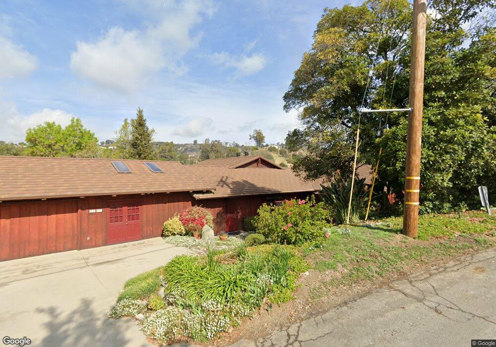
2020 Tumin Rd La Habra Heights, CA 90631
Estimated Value: $1,307,000 - $1,765,000
4
Beds
4
Baths
3,181
Sq Ft
$493/Sq Ft
Est. Value
About This Home
This home is located at 2020 Tumin Rd, La Habra Heights, CA 90631 and is currently estimated at $1,566,915, approximately $492 per square foot. 2020 Tumin Rd is a home located in Los Angeles County with nearby schools including El Portal Elementary School, Rancho-Starbuck Intermediate School, and Sonora High School.
Ownership History
Date
Name
Owned For
Owner Type
Purchase Details
Closed on
Jan 24, 2000
Sold by
Plant Shane and Plant Amy E
Bought by
Lehman Roger A
Current Estimated Value
Purchase Details
Closed on
Oct 8, 1998
Sold by
Redford J A C and Redford Leann A
Bought by
Plant Shane and Plant Amy E
Home Financials for this Owner
Home Financials are based on the most recent Mortgage that was taken out on this home.
Original Mortgage
$428,000
Interest Rate
6.25%
Create a Home Valuation Report for This Property
The Home Valuation Report is an in-depth analysis detailing your home's value as well as a comparison with similar homes in the area
Home Values in the Area
Average Home Value in this Area
Purchase History
| Date | Buyer | Sale Price | Title Company |
|---|---|---|---|
| Lehman Roger A | $577,000 | Chicago Title Co | |
| Plant Shane | $535,000 | North American Title Co |
Source: Public Records
Mortgage History
| Date | Status | Borrower | Loan Amount |
|---|---|---|---|
| Previous Owner | Plant Shane | $428,000 |
Source: Public Records
Tax History Compared to Growth
Tax History
| Year | Tax Paid | Tax Assessment Tax Assessment Total Assessment is a certain percentage of the fair market value that is determined by local assessors to be the total taxable value of land and additions on the property. | Land | Improvement |
|---|---|---|---|---|
| 2025 | $10,714 | $886,817 | $478,912 | $407,905 |
| 2024 | $10,714 | $869,429 | $469,522 | $399,907 |
| 2023 | $10,473 | $852,382 | $460,316 | $392,066 |
| 2022 | $10,359 | $835,670 | $451,291 | $384,379 |
| 2021 | $10,127 | $819,286 | $442,443 | $376,843 |
| 2019 | $9,849 | $794,987 | $429,321 | $365,666 |
| 2018 | $9,318 | $779,400 | $420,903 | $358,497 |
| 2016 | $8,688 | $749,136 | $404,559 | $344,577 |
| 2015 | $8,350 | $737,885 | $398,483 | $339,402 |
| 2014 | $8,270 | $723,432 | $390,678 | $332,754 |
Source: Public Records
Map
Nearby Homes
- 2240 Valle Dr
- 1929 Coban Rd
- 0 Airoso Rd
- 1573 Nabal Rd
- 918 Dorothea Rd
- 927 E Avocado Crest Rd
- 918 Reposado Dr
- 1500 Kashlan Rd
- 1445 Darlene Dr
- 739 Reposado Dr
- 1944 Chandos Ln
- 506 Dorothea Rd
- 171 Canada Sombre Rd
- 105 Reposado Dr
- 161 W Hidden Ln
- 220 Olinda Ave
- 1241 Arbolita Dr
- 1100 N Euclid St
- 18109 Graystone Way
- 1620 El Travesia Dr
- 1950 Tumin Rd
- 1963 Tumin Rd
- 1211 East Rd
- 1219 East Rd
- 2050 Tumin Rd
- 1333 Caminata Ln
- 2100 Valle Dr
- 1930 Tumin Rd
- 0 Camanita Unit PW14031801
- 2045 Tumin Rd
- 1325 Caminata Ln
- 1916 Tumin Rd
- 1336 Caminata Ln
- 1276 East Rd
- 2128 Valle Dr
- 1141 East Rd
- 1314 Caminata Ln
- 0 Tumin Unit PW17239116
- 0 Tumin Unit P803597
- 0 Tumin Unit P806687