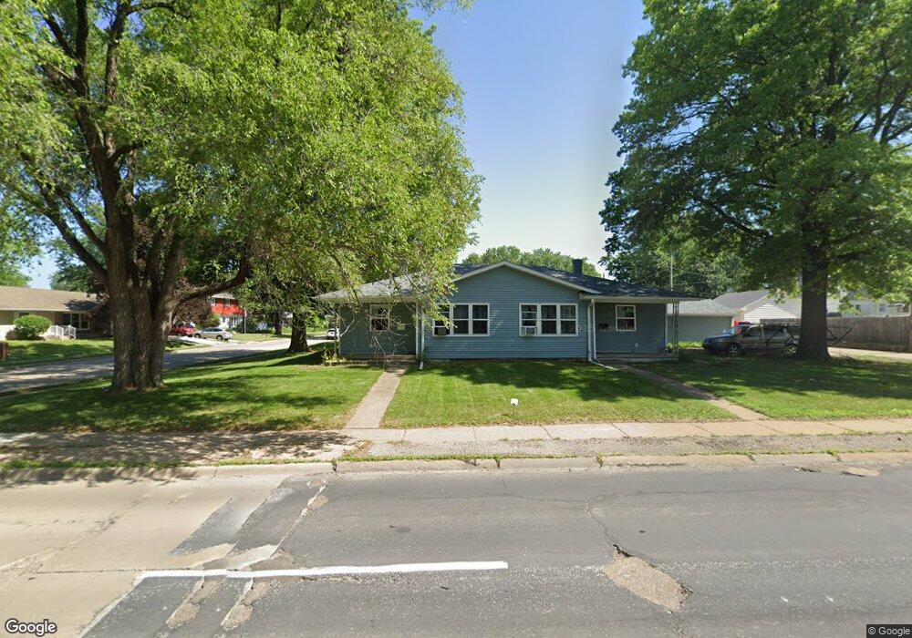
2020 W Central Park Ave Davenport, IA 52804
Northwest Davenport NeighborhoodEstimated Value: $181,000 - $221,000
4
Beds
2
Baths
1,704
Sq Ft
$121/Sq Ft
Est. Value
About This Home
This home is located at 2020 W Central Park Ave, Davenport, IA 52804 and is currently estimated at $206,760, approximately $121 per square foot. 2020 W Central Park Ave is a home located in Scott County with nearby schools including Tygart Creek Elementary School, South Christian Elementary School, and Adams Elementary School.
Ownership History
Date
Name
Owned For
Owner Type
Purchase Details
Closed on
Oct 24, 2006
Sold by
Dewuff Matthew M and Loken Peter M
Bought by
Kimberly Place Properties L L C
Current Estimated Value
Purchase Details
Closed on
Sep 21, 2006
Sold by
Hood James Michael and Hood Sherrie Lazar
Bought by
Dewulf Matthew M and Loken Peter M
Create a Home Valuation Report for This Property
The Home Valuation Report is an in-depth analysis detailing your home's value as well as a comparison with similar homes in the area
Home Values in the Area
Average Home Value in this Area
Purchase History
| Date | Buyer | Sale Price | Title Company |
|---|---|---|---|
| Kimberly Place Properties L L C | -- | None Available | |
| Dewulf Matthew M | $115,000 | None Available |
Source: Public Records
Tax History Compared to Growth
Tax History
| Year | Tax Paid | Tax Assessment Tax Assessment Total Assessment is a certain percentage of the fair market value that is determined by local assessors to be the total taxable value of land and additions on the property. | Land | Improvement |
|---|---|---|---|---|
| 2025 | $3,144 | $195,260 | $30,600 | $164,660 |
| 2024 | $3,320 | $175,880 | $30,600 | $145,280 |
| 2023 | $3,299 | $158,520 | $30,600 | $127,920 |
| 2022 | $3,080 | $149,260 | $30,600 | $118,660 |
| 2021 | $3,080 | $143,520 | $30,600 | $112,920 |
| 2020 | $2,904 | $129,170 | $30,600 | $98,570 |
| 2019 | $2,874 | $123,430 | $30,600 | $92,830 |
| 2018 | $890 | $123,430 | $30,600 | $92,830 |
| 2017 | $687 | $123,430 | $30,600 | $92,830 |
| 2016 | $2,970 | $116,730 | $0 | $0 |
| 2015 | $2,556 | $122,230 | $0 | $0 |
| 2014 | $2,714 | $122,230 | $0 | $0 |
| 2013 | $2,668 | $0 | $0 | $0 |
| 2012 | -- | $120,280 | $29,130 | $91,150 |
Source: Public Records
Map
Nearby Homes
- 2640 Wilkes Ave
- 2738 Kelling St
- 2424 Davie St
- 2820 Pacific St
- 2236 W Columbia Ave
- 2308 Wilkes Ave
- 2804 Oak St
- 1636 W Columbia Ave
- 2705 N Lincoln Ave
- 2223 W Lombard St
- 2103 W High St
- 2149 W 30th St
- 1658 W Lombard St
- 2508 N Sturdevant St
- 2905 N Pine St
- 2222 W 30th St
- 2221 Madison St
- 1548 W Central Park Ave
- 3011 N Pine St
- 3205 N Pine St
- 2018 W Central Park Ave
- 2018 W Central Park Ave
- 2611 Kelling St
- 2617 Kelling St
- 2604 Pacific St
- 2610 Pacific St
- 2021 W Central Park Ave
- 2616 Pacific St
- 2110 W Central Park Ave
- 2612 Kelling St
- 2526 Pacific St
- 2519 Kelling St
- 2625 Kelling St
- 2620 Kelling St
- 2103 W Central Park Ave
- 2522 Pacific St
- 2626 Pacific St
- 2515 Kelling St
- 2520 Kelling St
- 2518 Pacific St