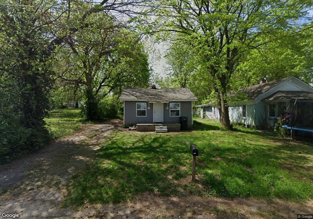
2020 W Lee St Springfield, MO 65803
Tom Watkins NeighborhoodEstimated Value: $72,461 - $91,000
1
Bed
1
Bath
560
Sq Ft
$152/Sq Ft
Est. Value
About This Home
This home is located at 2020 W Lee St, Springfield, MO 65803 and is currently estimated at $84,865, approximately $151 per square foot. 2020 W Lee St is a home located in Greene County with nearby schools including Williams Elementary School, Reed Academy, and Hillcrest High School.
Ownership History
Date
Name
Owned For
Owner Type
Purchase Details
Closed on
Aug 10, 2021
Sold by
Yugo Properties Llc
Bought by
Gray Family Trust
Current Estimated Value
Purchase Details
Closed on
Jul 21, 2021
Sold by
Ozarks House Buyers Llc
Bought by
Yugo Properties Llc
Purchase Details
Closed on
Mar 1, 2011
Sold by
Watson James Garnest and Watson Wiyle
Bought by
Mullins Bruce and Mullins Sherlyn
Create a Home Valuation Report for This Property
The Home Valuation Report is an in-depth analysis detailing your home's value as well as a comparison with similar homes in the area
Home Values in the Area
Average Home Value in this Area
Purchase History
| Date | Buyer | Sale Price | Title Company |
|---|---|---|---|
| Gray Family Trust | -- | None Listed On Document | |
| Gray Family Trust | -- | None Listed On Document | |
| Yugo Properties Llc | -- | None Available | |
| Yugo Properties Llc | -- | None Listed On Document | |
| Mullins Bruce | -- | None Available |
Source: Public Records
Tax History
| Year | Tax Paid | Tax Assessment Tax Assessment Total Assessment is a certain percentage of the fair market value that is determined by local assessors to be the total taxable value of land and additions on the property. | Land | Improvement |
|---|---|---|---|---|
| 2025 | $420 | $8,440 | $2,850 | $5,590 |
| 2024 | $388 | $7,240 | $1,900 | $5,340 |
| 2023 | $386 | $7,240 | $1,900 | $5,340 |
| 2022 | $317 | $5,810 | $1,900 | $3,910 |
| 2021 | $317 | $5,810 | $1,900 | $3,910 |
| 2020 | $311 | $5,450 | $1,900 | $3,550 |
| 2019 | $302 | $5,450 | $1,900 | $3,550 |
| 2018 | $232 | $4,180 | $1,900 | $2,280 |
| 2017 | $0 | $4,180 | $1,900 | $2,280 |
| 2016 | $229 | $4,180 | $1,900 | $2,280 |
| 2015 | $227 | $4,180 | $1,900 | $2,280 |
| 2014 | $229 | $4,180 | $1,900 | $2,280 |
Source: Public Records
Map
Nearby Homes
- 2104 N Park Ave
- 1956 W Atlantic St
- 2009 N Park Ave
- 2119 N Marion Ave
- 2105 N Elizabeth Ave
- 2111 N Elizabeth Ave
- 2130 N Park Ave
- 2130 N Elizabeth Ave
- 2101 N Grace Ave
- 2117 N Lexington Ave
- 2020 N Columbia Ave
- 2237 N Park Ave
- 2074 N Columbia Ave
- 2406 W High St
- 2217 N Grace Ave
- Lot 1 N Grace Ave
- Lot 13 N Grace Ave
- Lot 3 N Grace Ave
- Lot 2 N Grace Ave
- 1700 W Atlantic St
- 2026 W Lee St
- 2012 W Lee St
- 2104 W Lee St
- 2006 W Lee St
- 2114 W Lee St
- 2029 W Atlantic St
- 2011 W Atlantic St
- 2033 N Altertha Ave
- 2046 N Marion Ave
- 2033 N Albertha Ave
- 2041 N Marion Ave
- 2116 W Lee St
- 2101 W Atlantic St
- 2041 N Albertha Ave
- 2007 W Atlantic St
- 2109 W Atlantic St
- 2045 N Marion Ave
- 2113 W Lee St
- 2050 N Marion Ave
- 2001 W Atlantic St
Your Personal Tour Guide
Ask me questions while you tour the home.