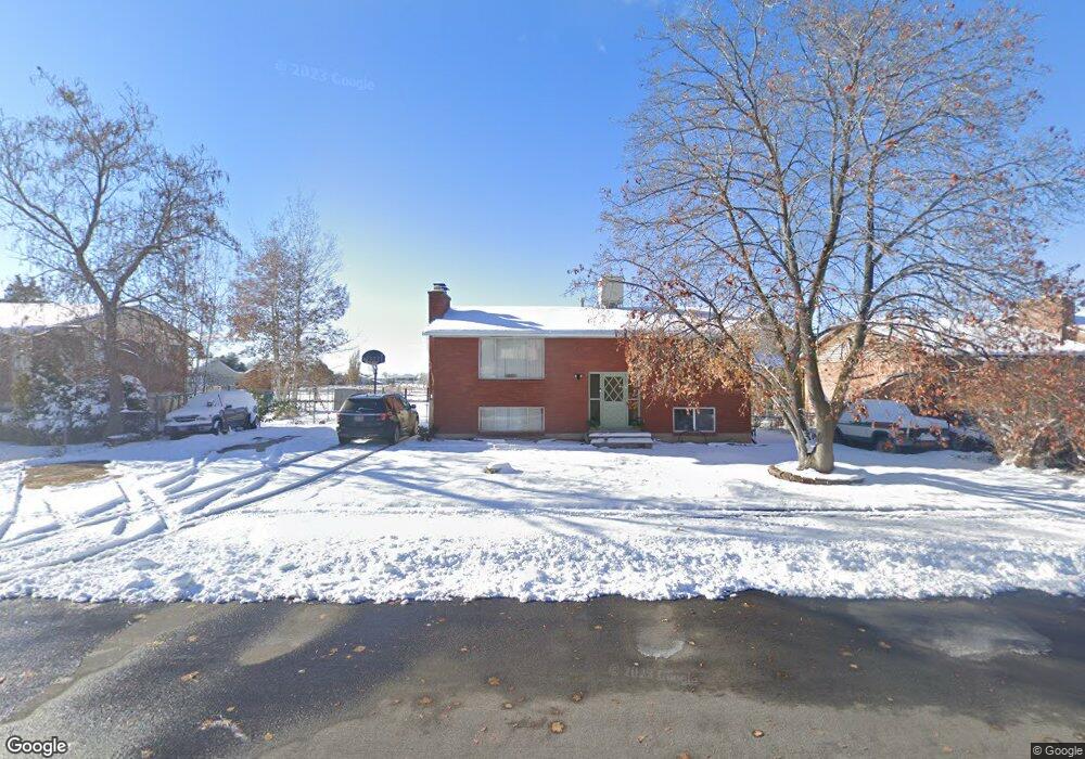
2021 N 3060 W Clearfield, UT 84015
Estimated Value: $424,000 - $463,000
5
Beds
2
Baths
1,900
Sq Ft
$230/Sq Ft
Est. Value
About This Home
This home is located at 2021 N 3060 W, Clearfield, UT 84015 and is currently estimated at $437,787, approximately $230 per square foot. 2021 N 3060 W is a home located in Davis County with nearby schools including West Clinton Elementary School, West Point Junior High School, and Clearfield High School.
Ownership History
Date
Name
Owned For
Owner Type
Purchase Details
Closed on
Feb 20, 2004
Sold by
Parkridge Inc
Bought by
Zavalza Agustin
Current Estimated Value
Purchase Details
Closed on
Aug 30, 1999
Sold by
Shelstead Timothy J
Bought by
Shelstead Tina G
Home Financials for this Owner
Home Financials are based on the most recent Mortgage that was taken out on this home.
Original Mortgage
$135,150
Interest Rate
9.75%
Create a Home Valuation Report for This Property
The Home Valuation Report is an in-depth analysis detailing your home's value as well as a comparison with similar homes in the area
Home Values in the Area
Average Home Value in this Area
Purchase History
| Date | Buyer | Sale Price | Title Company |
|---|---|---|---|
| Zavalza Agustin | -- | Heritage West Title Insuranc | |
| Shelstead Tina G | -- | Avis & Archibald Title Insur |
Source: Public Records
Mortgage History
| Date | Status | Borrower | Loan Amount |
|---|---|---|---|
| Previous Owner | Shelstead Tina G | $135,150 |
Source: Public Records
Tax History Compared to Growth
Tax History
| Year | Tax Paid | Tax Assessment Tax Assessment Total Assessment is a certain percentage of the fair market value that is determined by local assessors to be the total taxable value of land and additions on the property. | Land | Improvement |
|---|---|---|---|---|
| 2025 | $2,145 | $206,250 | $94,294 | $111,956 |
| 2024 | $2,060 | $199,100 | $103,235 | $95,865 |
| 2023 | $1,867 | $334,000 | $118,180 | $215,820 |
| 2022 | $1,996 | $197,450 | $71,409 | $126,041 |
| 2021 | $1,840 | $270,000 | $90,356 | $179,644 |
| 2020 | $1,597 | $232,000 | $77,478 | $154,522 |
| 2019 | $1,564 | $222,000 | $89,243 | $132,757 |
| 2018 | $1,399 | $195,000 | $74,604 | $120,396 |
| 2016 | $1,212 | $87,230 | $29,433 | $57,797 |
| 2015 | $1,167 | $79,860 | $29,433 | $50,427 |
| 2014 | $1,155 | $80,289 | $29,433 | $50,856 |
| 2013 | -- | $77,190 | $25,230 | $51,960 |
Source: Public Records
Map
Nearby Homes
- 3941 W 1800 N
- 2413 N Eurasian Crane Rd
- 339 N 3250 W Unit 12
- 2617 N 2080 W Unit 176
- 2118 Snowy Crane Dr
- 1648 N 2615 W
- 2219 N 2475 W
- 2542 N 3300 W
- Harvard Plan at Summerfield - Enclave
- 2208 W 2615 N
- Linden Plan at Summerfield - Vista
- Yale Plan at Summerfield - Enclave
- Gambel Oak Plan at Summerfield - Vista
- Cedar Plan at Summerfield - Vista
- Elm Plan at Summerfield - Vista
- Princeton Plan at Summerfield - Enclave
- Cambridge Plan at Summerfield - Enclave
- Cornell Plan at Summerfield - Enclave
- Sycamore Plan at Summerfield - Vista
- Berkeley Plan at Summerfield - Enclave
- 2003 N 3060 W
- 2033 N 3060 W
- 3097 W 2050 N
- 3097 W 2050 N Unit 1
- 1989 N 3060 W
- 2022 N 3060 W
- 2006 N 3060 W
- 2036 N 3060 W
- 3111 W 2050 N
- 3111 W 2050 N Unit 2
- 1992 N 3060 W
- 2023 N 3000 W
- 3133 W 2050 N
- 3133 W 2050 N Unit 3
- 1972 N 3060 W
- 2007 N 3000 W
- 2037 N 3000 W
- 1953 N 3060 W
- 1991 N 3000 W
- 2024 N 3060 W