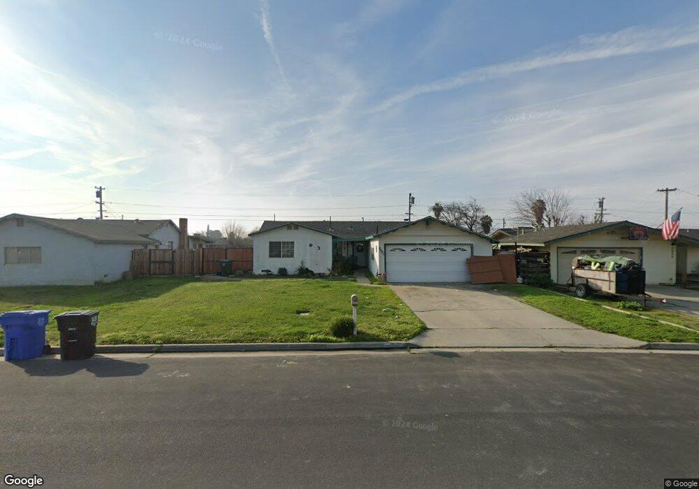
2021 Philip Ave Corcoran, CA 93212
Estimated Value: $254,000 - $269,000
3
Beds
2
Baths
1,305
Sq Ft
$199/Sq Ft
Est. Value
About This Home
This home is located at 2021 Philip Ave, Corcoran, CA 93212 and is currently estimated at $259,913, approximately $199 per square foot. 2021 Philip Ave is a home located in Kings County with nearby schools including John C. Fremont Elementary School, Bret Harte Elementary School, and Mark Twain Elementary School.
Ownership History
Date
Name
Owned For
Owner Type
Purchase Details
Closed on
Sep 10, 2025
Sold by
Gallardo Maria Imelda
Bought by
Gallardo Maria Imelda and Castillo Imelda Guadalupe
Current Estimated Value
Purchase Details
Closed on
Dec 11, 1996
Sold by
Johnson Auline S Living Trust
Bought by
Gallardo Victorio N and Gallardo Maria I
Home Financials for this Owner
Home Financials are based on the most recent Mortgage that was taken out on this home.
Original Mortgage
$74,881
Interest Rate
7.66%
Mortgage Type
FHA
Create a Home Valuation Report for This Property
The Home Valuation Report is an in-depth analysis detailing your home's value as well as a comparison with similar homes in the area
Purchase History
| Date | Buyer | Sale Price | Title Company |
|---|---|---|---|
| Gallardo Maria Imelda | -- | None Listed On Document | |
| Gallardo Victorio N | -- | Kings County Title Company | |
| Gallardo Victoria N | $75,000 | Kings County Title Company |
Source: Public Records
Mortgage History
| Date | Status | Borrower | Loan Amount |
|---|---|---|---|
| Previous Owner | Gallardo Victorio N | $74,881 |
Source: Public Records
Tax History
| Year | Tax Paid | Tax Assessment Tax Assessment Total Assessment is a certain percentage of the fair market value that is determined by local assessors to be the total taxable value of land and additions on the property. | Land | Improvement |
|---|---|---|---|---|
| 2025 | $1,194 | $122,147 | $45,600 | $76,547 |
| 2023 | $1,194 | $117,406 | $43,830 | $73,576 |
| 2022 | $1,152 | $115,105 | $42,971 | $72,134 |
| 2021 | $1,129 | $112,849 | $42,129 | $70,720 |
| 2020 | $1,114 | $111,692 | $41,697 | $69,995 |
| 2019 | $1,331 | $109,502 | $40,879 | $68,623 |
| 2018 | $1,314 | $107,354 | $40,077 | $67,277 |
| 2017 | $1,288 | $105,249 | $39,291 | $65,958 |
| 2016 | $1,040 | $103,186 | $38,521 | $64,665 |
| 2015 | $1,037 | $101,636 | $37,942 | $63,694 |
| 2014 | $1,018 | $99,645 | $37,199 | $62,446 |
Source: Public Records
Map
Nearby Homes
- 2220 North Ave
- 1766 North Ave
- 2217 Gable Ave
- 510 Claire Ave
- 508 Claire Ave
- 2312 North Ave
- 514 Josephine Ave
- 2023 Garvey Ave
- 2113 Garvey Ave
- 310 Wawona Ave
- 726 Josephine Ave
- 2310 Patterson Ave
- 1901 Patterson Ave
- 2323 Patterson Ave
- 0 Patterson Ave
- 446 6 1 2 Ave
- 2414 Strepy Ave
- 2615 Gable Ave
- 2632 North Ave
- 1040 Josephine Ave
- 2017 Philip Ave
- 2025 Philip Ave
- 2020 North Ave Unit A
- 2013 Philip Ave
- 2101 Circle Dr
- 2016 North Ave Unit B
- 2016 North Ave Unit C
- 2105 Circle Dr
- 2016 Philip Ave
- 2009 Philip Ave
- 2002 North Ave
- 2012 Philip Ave
- 2026 Philip Ave
- 2104 Philip Ave
- 2101 Philip Ave
- 2005 Philip Ave
- 2008 Philip Ave
- 2109 Circle Dr
- 2004 North Ave
- 2025 North Ave
Your Personal Tour Guide
Ask me questions while you tour the home.