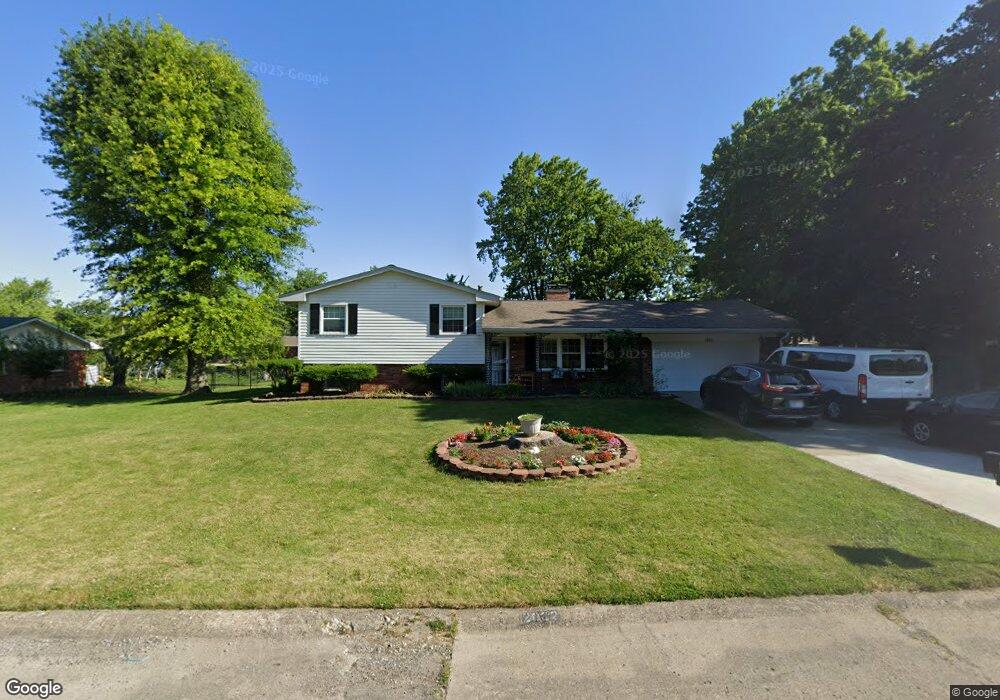
2022 Crossman Dr Indianapolis, IN 46227
South Perry NeighborhoodEstimated Value: $300,000 - $355,000
4
Beds
3
Baths
2,526
Sq Ft
$130/Sq Ft
Est. Value
About This Home
This home is located at 2022 Crossman Dr, Indianapolis, IN 46227 and is currently estimated at $329,154, approximately $130 per square foot. 2022 Crossman Dr is a home located in Marion County with nearby schools including Winchester Village Elementary School, Perry Meridian 6th Grade Academy, and Perry Meridian Middle School.
Ownership History
Date
Name
Owned For
Owner Type
Purchase Details
Closed on
Oct 15, 2021
Sold by
Mang Lian Za and Mang Zi Tial
Bought by
Aung Hmilh and Sung Chin
Current Estimated Value
Home Financials for this Owner
Home Financials are based on the most recent Mortgage that was taken out on this home.
Original Mortgage
$230,350
Outstanding Balance
$210,058
Interest Rate
2.8%
Mortgage Type
New Conventional
Estimated Equity
$119,096
Purchase Details
Closed on
Sep 18, 2020
Sold by
Mang Lian Za
Bought by
Mang Lian Za and Mang Zi Tial
Purchase Details
Closed on
May 2, 2016
Sold by
Warren Robert Adrian and Warren Ruby C
Bought by
Mang Lian Za
Home Financials for this Owner
Home Financials are based on the most recent Mortgage that was taken out on this home.
Original Mortgage
$154,057
Interest Rate
4.4%
Mortgage Type
FHA
Create a Home Valuation Report for This Property
The Home Valuation Report is an in-depth analysis detailing your home's value as well as a comparison with similar homes in the area
Home Values in the Area
Average Home Value in this Area
Purchase History
| Date | Buyer | Sale Price | Title Company |
|---|---|---|---|
| Aung Hmilh | $281,000 | None Available | |
| Mang Lian Za | -- | None Available | |
| Mang Lian Za | -- | None Available |
Source: Public Records
Mortgage History
| Date | Status | Borrower | Loan Amount |
|---|---|---|---|
| Open | Aung Hmilh | $230,350 | |
| Previous Owner | Mang Lian Za | $154,057 |
Source: Public Records
Tax History Compared to Growth
Tax History
| Year | Tax Paid | Tax Assessment Tax Assessment Total Assessment is a certain percentage of the fair market value that is determined by local assessors to be the total taxable value of land and additions on the property. | Land | Improvement |
|---|---|---|---|---|
| 2024 | $3,492 | $281,900 | $30,000 | $251,900 |
| 2023 | $3,492 | $267,100 | $30,000 | $237,100 |
| 2022 | $3,262 | $244,900 | $30,000 | $214,900 |
| 2021 | $2,649 | $197,400 | $30,000 | $167,400 |
| 2020 | $2,377 | $177,000 | $30,000 | $147,000 |
| 2019 | $2,274 | $168,900 | $26,400 | $142,500 |
| 2018 | $2,093 | $157,600 | $26,400 | $131,200 |
| 2017 | $2,032 | $153,200 | $26,400 | $126,800 |
| 2016 | $1,907 | $144,200 | $26,400 | $117,800 |
| 2014 | $1,844 | $155,800 | $26,400 | $129,400 |
| 2013 | $1,726 | $146,300 | $26,400 | $119,900 |
Source: Public Records
Map
Nearby Homes
- 2205 Remington Dr
- 1635 Remington Ct
- 8008 Cherington Dr
- 8416 Del Prado Ct
- 8361 Paso Del Norte Ct
- 8353 Paso Del Norte Ct
- 8365 Paso Del Norte Ct
- 8052 Snug Harbor Ln
- 2712 Palo Verde Ct Unit 37B
- 1607 E Stop 12 Rd
- 8045 Briarwood Dr
- 2765 Del Prado Dr Unit 7
- 2812 Del Prado Dr
- 2805 Del Prado Dr
- 8542 La Corrida Ct Unit 46A
- 2804 Punto Alto Cir
- 2866 Punto Alto Ct
- 8600 Madison Ave
- 7625 Homestead Dr
- 7819 S Oak Dr
- 2008 Crossman Dr
- 2104 Crossman Dr
- 2019 Remington Dr
- 2007 Remington Dr
- 2025 Crossman Dr
- 2029 Remington Dr
- 2015 Crossman Dr
- 1942 Crossman Dr
- 2105 Crossman Dr
- 2118 Crossman Dr
- 1941 Remington Dr
- 2003 Crossman Dr
- 2107 Remington Dr
- 2119 Crossman Dr
- 2006 Remington Dr
- 1931 Remington Dr
- 1932 Crossman Dr
- 2130 Crossman Dr
- 2106 Colt Rd
- 2024 Remington Dr