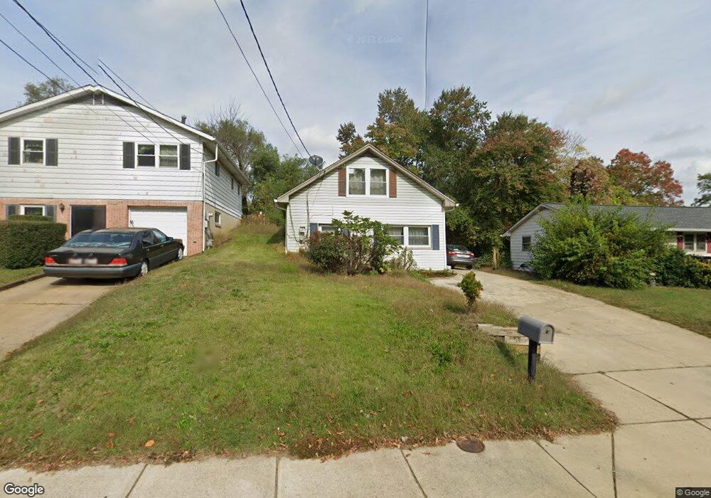
2022 Forest Dr Annapolis, MD 21401
Forest Villa NeighborhoodEstimated Value: $326,000 - $502,000
Studio
2
Baths
1,548
Sq Ft
$277/Sq Ft
Est. Value
About This Home
This home is located at 2022 Forest Dr, Annapolis, MD 21401 and is currently estimated at $428,060, approximately $276 per square foot. 2022 Forest Dr is a home located in Anne Arundel County with nearby schools including Walter S. Mills-Parole Elementary School, Annapolis Middle School, and Annapolis High School.
Ownership History
Date
Name
Owned For
Owner Type
Purchase Details
Closed on
Aug 8, 2003
Sold by
Hutton Alvin A
Bought by
Vargas Sola Victoriano and Vargas Marina
Current Estimated Value
Purchase Details
Closed on
Sep 7, 2001
Sold by
Hutton Alvin Alex
Bought by
Hutton Alvin A
Purchase Details
Closed on
Dec 1, 2000
Sold by
Hutton Helen E
Bought by
Hutton Alvin Alex and Hutton Alvin Alex
Create a Home Valuation Report for This Property
The Home Valuation Report is an in-depth analysis detailing your home's value as well as a comparison with similar homes in the area
Home Values in the Area
Average Home Value in this Area
Purchase History
| Date | Buyer | Sale Price | Title Company |
|---|---|---|---|
| Vargas Sola Victoriano | $159,900 | -- | |
| Hutton Alvin A | -- | -- | |
| Hutton Alvin Alex | $31,500 | -- |
Source: Public Records
Mortgage History
| Date | Status | Borrower | Loan Amount |
|---|---|---|---|
| Closed | Vargas Sola Victoriano | -- |
Source: Public Records
Tax History
| Year | Tax Paid | Tax Assessment Tax Assessment Total Assessment is a certain percentage of the fair market value that is determined by local assessors to be the total taxable value of land and additions on the property. | Land | Improvement |
|---|---|---|---|---|
| 2025 | $4,270 | $338,833 | -- | -- |
| 2024 | $4,270 | $297,167 | $0 | $0 |
| 2023 | $3,669 | $255,500 | $154,400 | $101,100 |
| 2022 | $3,476 | $246,700 | $0 | $0 |
| 2021 | $3,230 | $237,900 | $0 | $0 |
| 2020 | $3,230 | $229,100 | $133,400 | $95,700 |
| 2019 | $3,195 | $226,467 | $0 | $0 |
| 2018 | $3,114 | $223,833 | $0 | $0 |
| 2017 | $2,887 | $221,200 | $0 | $0 |
| 2016 | -- | $214,667 | $0 | $0 |
| 2015 | -- | $208,133 | $0 | $0 |
| 2014 | -- | $201,600 | $0 | $0 |
Source: Public Records
Map
Nearby Homes
- 14 A Dorsey Ave
- 8 Dorsey Ave
- 706 Agnes Dorsey Place
- 606 James Walker Place
- 1915 Towne Centre Blvd Unit 1001
- 1915 Towne Centre Blvd Unit 301
- 1915 Towne Centre Blvd Unit 606
- 1915 Towne Centre Blvd Unit 807
- 1915 Towne Centre Blvd Unit 309
- 1915 Towne Centre Blvd Unit 406
- 1915 Towne Centre Blvd Unit 707
- 1915 Towne Centre Blvd Unit 402
- 1915 Towne Centre Blvd Unit 1210
- 1915 Towne Centre Blvd Unit 1004
- 1915 Towne Centre Blvd Unit 502
- 612 Severn Island Ct
- 206 Admiral Dr
- 1808 Lincoln Dr
- 16 Wilelinor Dr
- 1403 Corey Ln
- 2024 Forest Dr
- 2020 Forest Dr
- 2026 Forest Dr
- 2040 Forest Dr
- 2041 Forest Dr
- 2046 Forest Dr
- 401 Oaklawn Ave
- 393 Oaklawn Ave
- 2016 Forest Dr
- 2043 Forest Dr
- 403 Oaklawn Ave
- 2045 Forest Dr
- 405 Oaklawn Ave
- 31 Carver St Unit F
- 31 Carver St Unit D
- 31 Carver St Unit B
- 31 Carver St Unit E
- 31 Carver St Unit C
- 31 Carver St Unit A
- 31 Carver St
Your Personal Tour Guide
Ask me questions while you tour the home.