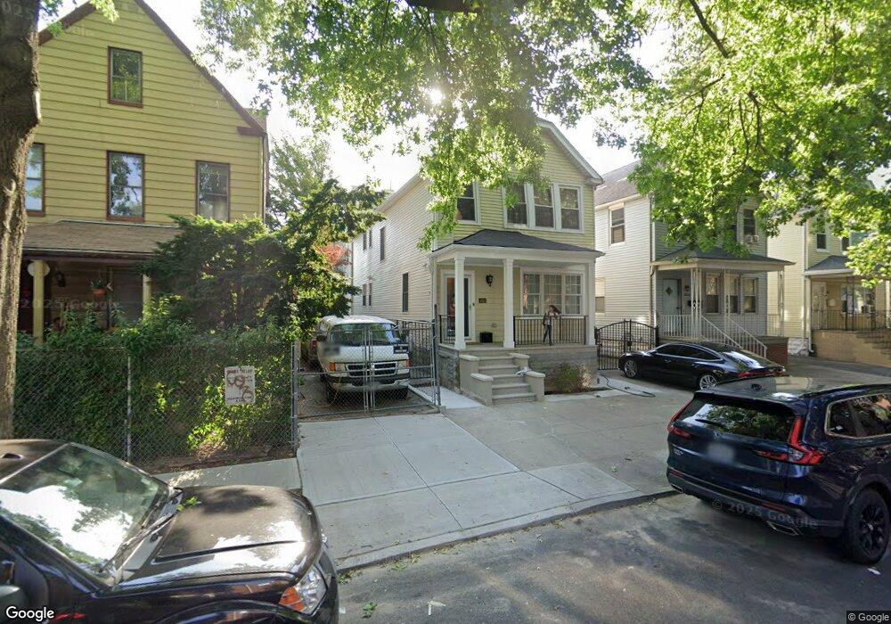
2022 Saint Paul Ave Bronx, NY 10461
Middletown-Pelham Bay NeighborhoodEstimated Value: $766,201 - $939,000
--
Bed
--
Bath
1,920
Sq Ft
$456/Sq Ft
Est. Value
About This Home
This home is located at 2022 Saint Paul Ave, Bronx, NY 10461 and is currently estimated at $875,800, approximately $456 per square foot. 2022 Saint Paul Ave is a home located in Bronx County with nearby schools including P.S. 71 Rose E Scala, Herbert H Lehman High School, and Icahn Charter School 3.
Ownership History
Date
Name
Owned For
Owner Type
Purchase Details
Closed on
Apr 26, 2016
Sold by
Ayub Narmeen and Bashir Jamal A
Bought by
Ayub Narmeen and Nawaz Ataf A
Current Estimated Value
Purchase Details
Closed on
Jul 11, 2012
Sold by
Mathews Susy
Bought by
Ayub Narmeen and Bashir Jamal A
Purchase Details
Closed on
Jul 20, 2005
Sold by
Pathy Shyla and Pathy Venkatachala
Bought by
Mathews Susy
Create a Home Valuation Report for This Property
The Home Valuation Report is an in-depth analysis detailing your home's value as well as a comparison with similar homes in the area
Home Values in the Area
Average Home Value in this Area
Purchase History
| Date | Buyer | Sale Price | Title Company |
|---|---|---|---|
| Ayub Narmeen | -- | -- | |
| Ayub Narmeen | -- | -- | |
| Mathews Susy | $480,000 | -- |
Source: Public Records
Tax History Compared to Growth
Tax History
| Year | Tax Paid | Tax Assessment Tax Assessment Total Assessment is a certain percentage of the fair market value that is determined by local assessors to be the total taxable value of land and additions on the property. | Land | Improvement |
|---|---|---|---|---|
| 2025 | $7,774 | $41,028 | $8,119 | $32,909 |
| 2024 | $7,774 | $38,707 | $9,123 | $29,584 |
| 2023 | $7,686 | $37,843 | $8,505 | $29,338 |
| 2022 | $7,215 | $41,280 | $10,140 | $31,140 |
| 2021 | $7,331 | $38,220 | $10,140 | $28,080 |
| 2020 | $7,237 | $40,740 | $10,140 | $30,600 |
| 2019 | $6,748 | $32,820 | $10,140 | $22,680 |
| 2018 | $6,429 | $31,536 | $9,317 | $22,219 |
| 2017 | $6,140 | $30,120 | $10,140 | $19,980 |
| 2016 | $5,803 | $29,030 | $8,920 | $20,110 |
| 2015 | $3,473 | $28,492 | $9,956 | $18,536 |
| 2014 | $3,473 | $26,880 | $11,280 | $15,600 |
Source: Public Records
Map
Nearby Homes
- 2015 Saint Paul Ave Unit 3H
- 2015 St Paul Ave Unit 3G
- 2015 Saint Paul Ave Unit 6B
- 2024 Continental Ave
- 2032 Hobart Ave
- 2010 Hobart Ave
- 2887 E 194th St
- 1874 Pelham Pkwy S Unit 6M
- 1874 Pelham Pkwy S Unit 5B
- 1874 Pelham Pkwy S Unit 6E
- 1874 Pelham Pkwy S Unit 4R
- 1910 Pelham Pkwy S Unit 5C
- 2871 E 194th St
- 2849 E 195th St
- 1950 Pilgrim Ave
- 2884 Saint Theresa Ave
- 1926 Hutchinson River Pkwy E Unit E
- 3036 Buhre Ave
- 1865 Mulford Ave
- 1711 Mahan Ave
- 2020 Saint Paul Ave
- 2018 Saint Paul Ave
- 2032 Saint Paul Ave
- 2016 Saint Paul Ave
- 2029 Colonial Ave
- 2015 Colonial Ave
- 2031 Colonial Ave
- 2014 Saint Paul Ave
- 2033 Colonial Ave
- 2042 Saint Paul Ave
- 2037 Colonial Ave
- 2031 Saint Paul Ave
- 2033 Saint Paul Ave
- 2013 Colonial Ave Unit 6B
- 2013 Colonial Ave Unit 6A
- 2013 Colonial Ave Unit 5B
- 2013 Colonial Ave Unit 5A
- 2013 Colonial Ave Unit 4B
- 2013 Colonial Ave Unit 4A
- 2013 Colonial Ave Unit 3B