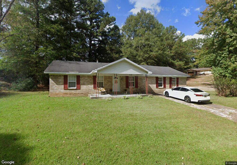
2023 Brandywine Dr Oxford, MS 38655
Estimated Value: $185,000 - $429,000
Studio
1
Bath
1,692
Sq Ft
$164/Sq Ft
Est. Value
About This Home
This home is located at 2023 Brandywine Dr, Oxford, MS 38655 and is currently estimated at $277,000, approximately $163 per square foot. 2023 Brandywine Dr is a home located in Lafayette County with nearby schools including Bramlett Elementary School, Della Davidson Elementary School, and Central Elementary School.
Ownership History
Date
Name
Owned For
Owner Type
Purchase Details
Closed on
Feb 1, 2024
Sold by
Pettis Mary Ann
Bought by
Pegues Bobby and Pegues Clara
Current Estimated Value
Purchase Details
Closed on
Apr 30, 2021
Sold by
Mathis Deroyrick and Estate Of Roy Lee Mathis Jr
Bought by
Pegues Lamar
Home Financials for this Owner
Home Financials are based on the most recent Mortgage that was taken out on this home.
Original Mortgage
$61,203
Interest Rate
3.1%
Mortgage Type
Credit Line Revolving
Create a Home Valuation Report for This Property
The Home Valuation Report is an in-depth analysis detailing your home's value as well as a comparison with similar homes in the area
Purchase History
| Date | Buyer | Sale Price | Title Company |
|---|---|---|---|
| Pegues Bobby | -- | None Listed On Document | |
| Pegues Lamar | -- | None Available |
Source: Public Records
Mortgage History
| Date | Status | Borrower | Loan Amount |
|---|---|---|---|
| Previous Owner | Pegues Lamar | $61,203 |
Source: Public Records
Tax History
| Year | Tax Paid | Tax Assessment Tax Assessment Total Assessment is a certain percentage of the fair market value that is determined by local assessors to be the total taxable value of land and additions on the property. | Land | Improvement |
|---|---|---|---|---|
| 2025 | $1,735 | $13,334 | $0 | $0 |
| 2024 | $1,735 | $11,534 | $0 | $0 |
| 2023 | $1,524 | $11,534 | $0 | $0 |
| 2022 | $1,501 | $11,534 | $0 | $0 |
| 2021 | $415 | $11,534 | $0 | $0 |
| 2020 | $435 | $12,432 | $0 | $0 |
| 2019 | $435 | $12,432 | $0 | $0 |
| 2018 | $156 | $8,288 | $0 | $0 |
| 2017 | $156 | $8,288 | $0 | $0 |
| 2016 | $129 | $7,810 | $0 | $0 |
| 2015 | -- | $7,810 | $0 | $0 |
| 2014 | -- | $7,810 | $0 | $0 |
Source: Public Records
Map
Nearby Homes
- 36A County Road 2003
- 0 Cannon Rd Tract 1 10 06 Ac
- 0 Cannon Rd 10 06 Ac Tract 1
- 0
- 107 Hedges Cove
- 203 Mississippi 6
- 720 Primrose Dr
- 311 Peony Place
- 304 Peony Place
- 302 Peony Place
- 308 Peony Place
- 306 Peony Place
- tbd Hwy 6 W
- 112 Cr 213
- 307 Peony Place
- 303 Peony Place
- 1503 Larhonda Dr
- 177 Honeysuckle Way
- 2335 University Ave
- 2333 University Ave
- 3011 Hillmont Dr
- 2021 Brandywine Dr
- 2018 Brandywine Dr
- 2020 Brandywine Dr
- 2022 Brandywine Dr
- 3012 Hillmont Dr
- 2025 Brandywine Dr
- 3009 Hillmont Dr
- 2016 Brandywine Dr
- 2019 Brandywine Dr
- 3010 Hillmont Dr
- 2016 Brandywine Dr
- 3008 Hillmont Dr
- 3007 Hillmont Dr
- 0 County Road 2003
- 00 County Road 2003
- 22 Cannon Rd
- 2015 Briarfield Cove
- 2017 Briarfield Cove
- 2029 Brandywine Dr
Your Personal Tour Guide
Ask me questions while you tour the home.