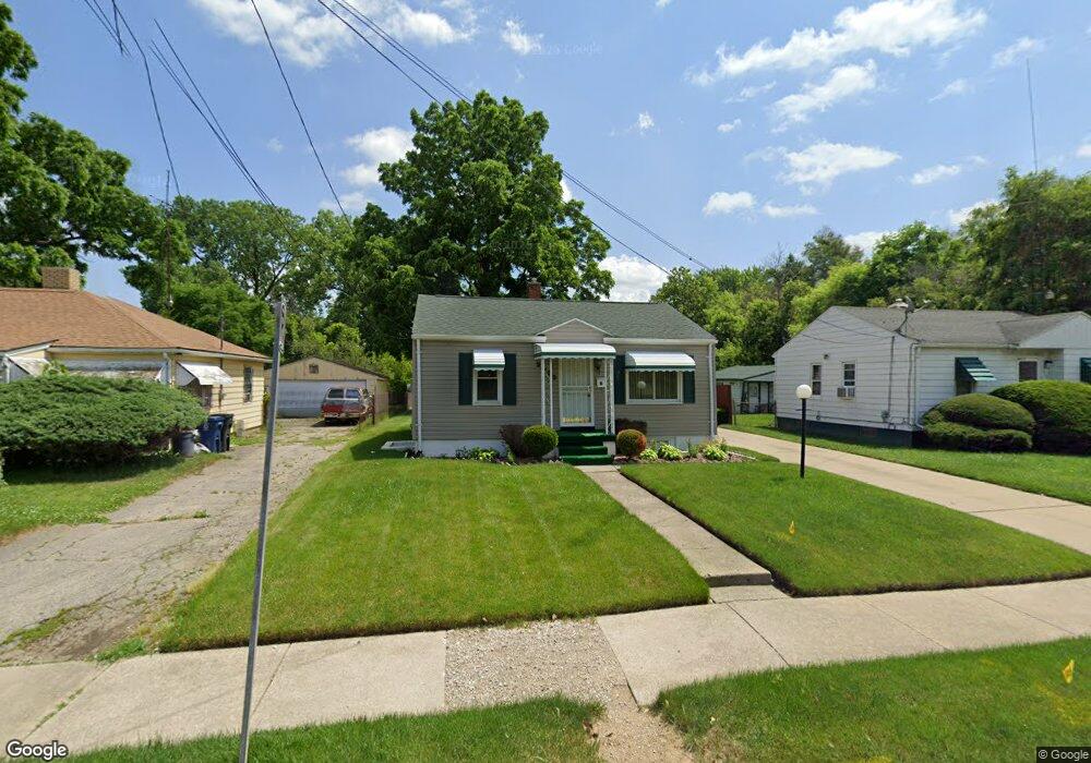
2023 Clifford St Flint, MI 48503
South Parks NeighborhoodEstimated Value: $40,000 - $61,000
2
Beds
1
Bath
700
Sq Ft
$73/Sq Ft
Est. Value
About This Home
This home is located at 2023 Clifford St, Flint, MI 48503 and is currently estimated at $50,870, approximately $72 per square foot. 2023 Clifford St is a home located in Genesee County with nearby schools including Freeman Elementary School, Flint Southwestern Classical Academy, and International Academy of Flint (K-12).
Ownership History
Date
Name
Owned For
Owner Type
Purchase Details
Closed on
Sep 18, 2025
Sold by
Bell Samuel
Bought by
Tolon Kevin
Current Estimated Value
Purchase Details
Closed on
Aug 26, 1999
Sold by
Bernadette J Darby Estate
Bought by
Tolan Mary A
Purchase Details
Closed on
Nov 20, 1989
Sold by
Tolon Mary A Anthony
Bought by
Tolon Mary A Anthony and Tolon Kevin Korey
Create a Home Valuation Report for This Property
The Home Valuation Report is an in-depth analysis detailing your home's value as well as a comparison with similar homes in the area
Home Values in the Area
Average Home Value in this Area
Purchase History
| Date | Buyer | Sale Price | Title Company |
|---|---|---|---|
| Tolon Kevin | -- | Select Title | |
| Tolan Mary A | $14,000 | Sargents Abstract & Title Co | |
| Tolon Mary A Anthony | -- | Titlequest |
Source: Public Records
Tax History Compared to Growth
Tax History
| Year | Tax Paid | Tax Assessment Tax Assessment Total Assessment is a certain percentage of the fair market value that is determined by local assessors to be the total taxable value of land and additions on the property. | Land | Improvement |
|---|---|---|---|---|
| 2025 | $708 | $17,800 | $0 | $0 |
| 2024 | $651 | $15,100 | $0 | $0 |
| 2023 | $645 | $12,900 | $0 | $0 |
| 2022 | $0 | $11,200 | $0 | $0 |
| 2021 | $664 | $9,800 | $0 | $0 |
| 2020 | $609 | $9,500 | $0 | $0 |
| 2019 | $599 | $8,300 | $0 | $0 |
| 2018 | $577 | $6,900 | $0 | $0 |
| 2017 | $628 | $0 | $0 | $0 |
| 2016 | $624 | $0 | $0 | $0 |
| 2015 | -- | $0 | $0 | $0 |
| 2014 | -- | $0 | $0 | $0 |
| 2012 | -- | $10,800 | $0 | $0 |
Source: Public Records
Map
Nearby Homes
- 420 Pingree Ave
- 2050 Ferris Ave
- 2010 Crocker Ave
- 2224 Crocker Ave
- 2029 Aitken Ave
- 1110 Pingree Ave
- 149 E Tobias St
- 2221 Howard Ave
- 133 E Oakley St
- 517 Morley Ave
- 636 Partridge St
- 1517 Tacoma St
- 1511 Tacoma St
- 841 E 8th St
- A Avenue
- 1851 Seymour Ave
- 3218 Collingwood Pkwy
- 911 E 7th St
- 213 E Lakeview Ave
- 1114 S Grand Traverse St
- 2027 Clifford St
- 2019 Clifford St
- 2015 Clifford St
- 2034 Warner Ave
- 2026 Warner Ave
- 2030 Clifford St
- 2038 Warner Ave
- 2022 Clifford St
- 2030 Warner Ave
- 2042 Warner Ave
- 2012 Clifford St
- 2050 Warner Ave
- 2010 Clifford St
- 2046 Clifford St
- 302 E 15th St
- 218 E 15th St
- 2033 Warner Ave
- 2041 Warner Ave
- 2045 Warner Ave
- 2049 Warner Ave