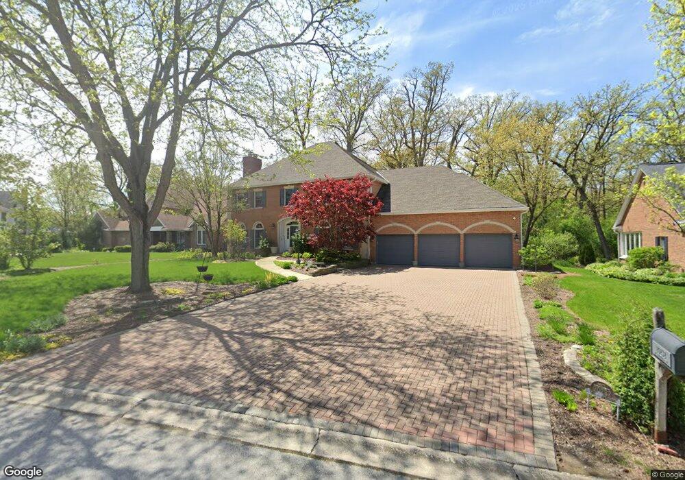
20232 Saint Andrews Dr Olympia Fields, IL 60461
Estimated Value: $397,609 - $494,000
4
Beds
3
Baths
2,900
Sq Ft
$155/Sq Ft
Est. Value
About This Home
This home is located at 20232 Saint Andrews Dr, Olympia Fields, IL 60461 and is currently estimated at $450,652, approximately $155 per square foot. 20232 Saint Andrews Dr is a home located in Cook County with nearby schools including Western Avenue Elementary School, Parker Junior High School, and Infant Jesus of Prague School.
Ownership History
Date
Name
Owned For
Owner Type
Purchase Details
Closed on
Jan 22, 2025
Sold by
Bongard Richard J and Bongard Richard H
Bought by
Richard H Bongard Trust and Beth A Bongard Trust
Current Estimated Value
Create a Home Valuation Report for This Property
The Home Valuation Report is an in-depth analysis detailing your home's value as well as a comparison with similar homes in the area
Home Values in the Area
Average Home Value in this Area
Purchase History
| Date | Buyer | Sale Price | Title Company |
|---|---|---|---|
| Richard H Bongard Trust | -- | None Listed On Document |
Source: Public Records
Tax History
| Year | Tax Paid | Tax Assessment Tax Assessment Total Assessment is a certain percentage of the fair market value that is determined by local assessors to be the total taxable value of land and additions on the property. | Land | Improvement |
|---|---|---|---|---|
| 2025 | $13,261 | $38,000 | $9,480 | $28,520 |
| 2024 | $13,261 | $38,000 | $9,480 | $28,520 |
| 2023 | $11,468 | $38,000 | $9,480 | $28,520 |
| 2022 | $11,468 | $27,616 | $8,295 | $19,321 |
| 2021 | $11,575 | $27,615 | $8,295 | $19,320 |
| 2020 | $10,859 | $27,615 | $8,295 | $19,320 |
| 2019 | $13,311 | $32,508 | $7,505 | $25,003 |
| 2018 | $12,946 | $32,508 | $7,505 | $25,003 |
| 2017 | $13,990 | $32,508 | $7,505 | $25,003 |
| 2016 | $13,656 | $30,568 | $6,715 | $23,853 |
| 2015 | $13,587 | $30,568 | $6,715 | $23,853 |
| 2014 | $13,274 | $30,568 | $6,715 | $23,853 |
| 2013 | $13,340 | $33,376 | $6,715 | $26,661 |
Source: Public Records
Map
Nearby Homes
- 31 Graymoor Ln
- 136 Graymoor Ln
- 2724 Chariot Ln
- 2700 Chariot Ln
- 634 Lexington Dr
- 2509 207th St
- 20015 Delphi Dr
- 2904 Athena Ct
- 2908 Athena Ct
- 1723 Oak Lane Rd
- 2925 Dartmouth Ln
- 542 Winston Ln
- 2935 Dartmouth Ln
- 1816 Quail Ct
- 2433 Athens Rd
- 823 Bradoc St
- 531 W Winchester Rd
- 505 W Joe Orr Rd
- 523 8th St
- 2312 209th St
- 20242 St Andrews Dr
- 20222 St Andrews Dr
- 20222 Saint Andrews Dr
- 20242 Saint Andrews Dr
- 2617 Oakwood Dr
- 20212 Saint Andrews Dr
- 2551 Glen Eagles Dr
- 20223 Saint Andrews Dr
- 2530 Glen Eagles Dr
- 2541 Glen Eagles Dr
- 2621 Oakwood Dr
- 20213 Saint Andrews Dr
- 20180 Saint Andrews Dr
- 2641 Oakwood Dr
- 2531 Glen Eagles Dr
- 20170 Saint Andrews Dr
- 2520 Glen Eagles Dr
- 20203 Saint Andrews Dr
- 20160 St Andrews Dr Unit 3
- 20210 Saint Andrews Ct
Your Personal Tour Guide
Ask me questions while you tour the home.