Estimated Value: $319,000 - $389,000
3
Beds
2
Baths
1,555
Sq Ft
$218/Sq Ft
Est. Value
About This Home
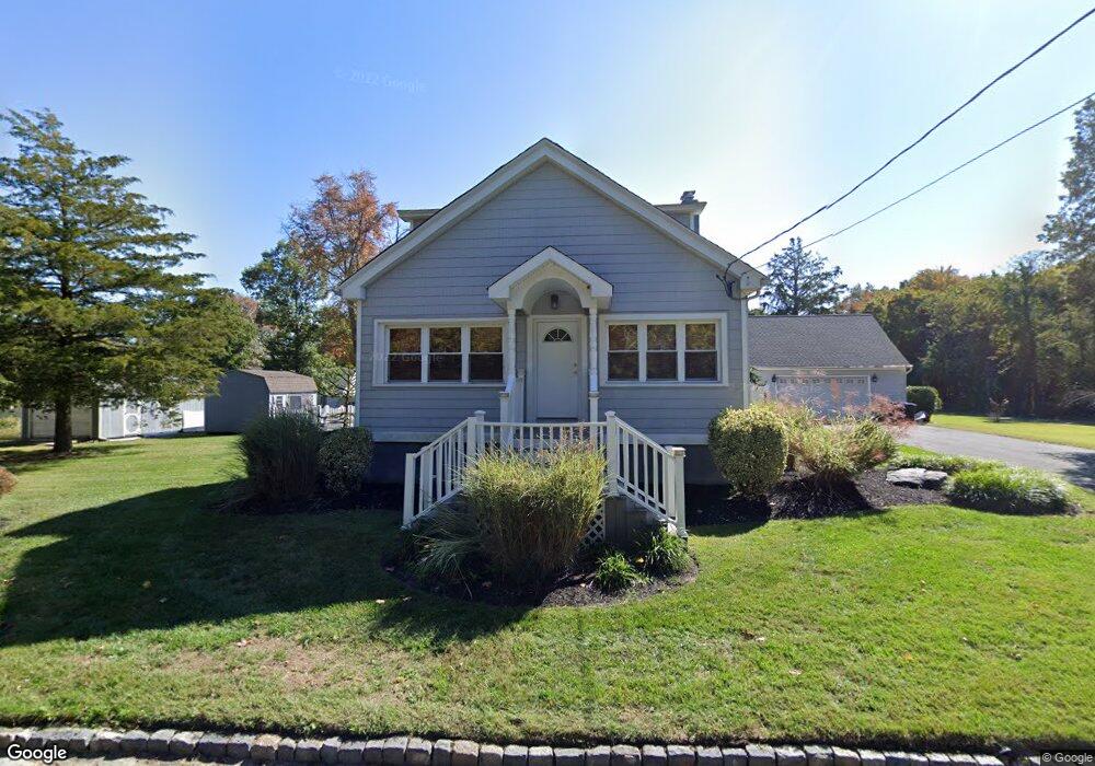
This home is located at 2024 Elm Ave, Atco, NJ 08004 and is currently estimated at $339,134, approximately $218 per square foot. 2024 Elm Ave is a home located in Camden County with nearby schools including Waterford Elementary School, Thomas Richards Elementary School, and Atco Elementary School.
Ownership History
Date
Name
Owned For
Owner Type
Purchase Details
Closed on
Nov 2, 2018
Sold by
Raio Dominick A and U S Bank Na
Bought by
Raio Dominick
Current Estimated Value
Purchase Details
Closed on
Mar 13, 2009
Sold by
Raio Dominick and Raio Donna M
Bought by
Raio Domincik A
Home Financials for this Owner
Home Financials are based on the most recent Mortgage that was taken out on this home.
Original Mortgage
$118,335
Interest Rate
5.25%
Mortgage Type
FHA
Purchase Details
Closed on
Dec 4, 2003
Sold by
Sprenger James E
Bought by
Raio Dominick and Raio Donna M
Purchase Details
Closed on
Nov 22, 1996
Sold by
Tambone Marie L
Bought by
Sprenger James E and Sprenger Michelle L
Home Financials for this Owner
Home Financials are based on the most recent Mortgage that was taken out on this home.
Original Mortgage
$90,000
Interest Rate
7.75%
Mortgage Type
FHA
Create a Home Valuation Report for This Property
The Home Valuation Report is an in-depth analysis detailing your home's value as well as a comparison with similar homes in the area
Home Values in the Area
Average Home Value in this Area
Purchase History
| Date | Buyer | Sale Price | Title Company |
|---|---|---|---|
| Raio Dominick | $124,000 | None Available | |
| Raio Domincik A | $166,000 | -- | |
| Raio Dominick | $84,000 | -- | |
| Sprenger James E | $89,900 | -- |
Source: Public Records
Mortgage History
| Date | Status | Borrower | Loan Amount |
|---|---|---|---|
| Previous Owner | Raio Domincik A | $118,335 | |
| Previous Owner | Sprenger James E | $90,000 |
Source: Public Records
Tax History Compared to Growth
Tax History
| Year | Tax Paid | Tax Assessment Tax Assessment Total Assessment is a certain percentage of the fair market value that is determined by local assessors to be the total taxable value of land and additions on the property. | Land | Improvement |
|---|---|---|---|---|
| 2025 | $6,613 | $150,100 | $47,600 | $102,500 |
| 2024 | $6,450 | $150,100 | $47,600 | $102,500 |
| 2023 | $6,450 | $150,100 | $47,600 | $102,500 |
| 2022 | $6,163 | $150,100 | $47,600 | $102,500 |
| 2021 | $6,133 | $150,100 | $47,600 | $102,500 |
| 2020 | $6,103 | $150,100 | $47,600 | $102,500 |
| 2019 | $6,010 | $150,100 | $47,600 | $102,500 |
| 2018 | $6,004 | $150,100 | $47,600 | $102,500 |
| 2017 | $5,911 | $150,100 | $47,600 | $102,500 |
| 2016 | $5,825 | $150,100 | $47,600 | $102,500 |
| 2015 | $5,672 | $150,100 | $47,600 | $102,500 |
| 2014 | $5,269 | $95,400 | $29,500 | $65,900 |
Source: Public Records
Map
Nearby Homes
- 785 White Horse Pike
- 2020 Merion Ave
- 2076 Hendricks Ave
- 320 White Horse Pike
- 327 Vineyard Rd
- 249 Girard Ave
- 221 White Horse Pike
- 132 Miller Ave
- 422 Grant Ave
- 158 Baker Ave
- 524 White Horse Pike
- 510 White Horse Pike
- 252 Hayes Mill Rd
- 194 Gibbons Ct
- 509 3rd Ave
- 2216 Harrison Ave
- 2216 Harrison Ave
- 2239 Ellwood Ave
- 0 Edwards Ave Unit NJCD2104922
- Nassau Cove with Unfinished Basement Plan at Waterbury Woods 55+
- 2029 Norris Ave
- 2035 Norris Ave
- 2026 Ohio Ave
- 647 Pacific Ave
- 2020 Ohio Ave
- 772 White Horse Pike
- 655 Pacific Ave
- 2016 Ohio Ave
- 654 Pacific Ave
- 2042 Norris Ave
- 2033 Lambert Ave
- 614 Pacific Ave
- 769 W Atlantic Ave
- 2014 Norris Ave
- 766 White Horse Pike Unit 2
- 766 White Horse Pike Unit 5
- 766 White Horse Pike
- 661 Pacific Ave
- 2010 Ohio Ave
- 2010 Norris Ave