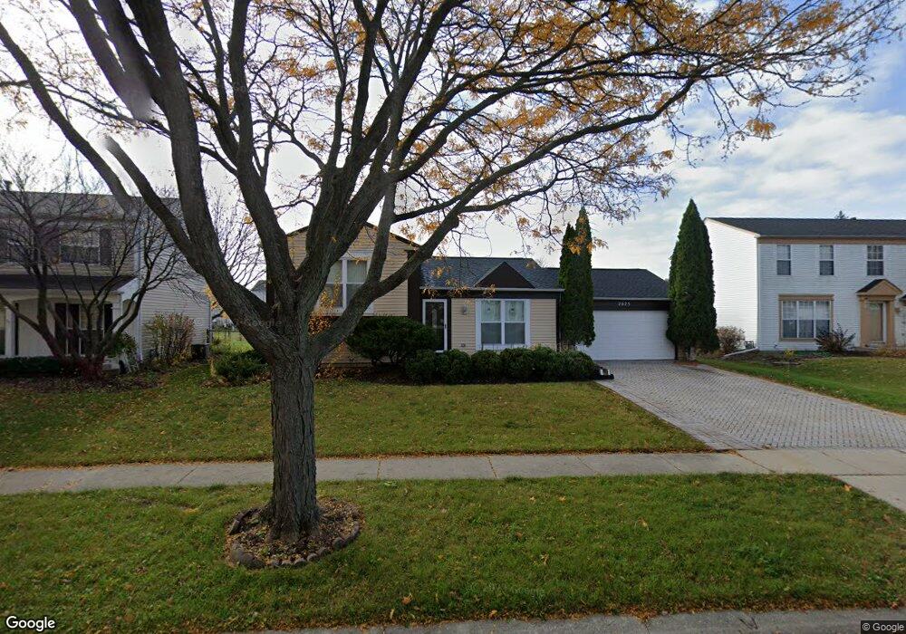
2025 Aronomink Cir Elgin, IL 60123
College Green NeighborhoodEstimated Value: $326,000 - $340,000
3
Beds
2
Baths
1,456
Sq Ft
$229/Sq Ft
Est. Value
About This Home
This home is located at 2025 Aronomink Cir, Elgin, IL 60123 and is currently estimated at $334,057, approximately $229 per square foot. 2025 Aronomink Cir is a home located in Kane County with nearby schools including Otter Creek Elementary School, Abbott Middle School, and South Elgin High School.
Ownership History
Date
Name
Owned For
Owner Type
Purchase Details
Closed on
Mar 18, 2004
Sold by
Donjuan Arturo and Perez Fortino
Bought by
Donjuan Arturo and Donjuan Ana Maria
Current Estimated Value
Home Financials for this Owner
Home Financials are based on the most recent Mortgage that was taken out on this home.
Original Mortgage
$160,300
Interest Rate
5.99%
Mortgage Type
New Conventional
Purchase Details
Closed on
Feb 1, 2002
Sold by
Johnson Dana L and Dana L Johnson Declaration Of
Bought by
Juan Arturo Don and Perez Fortino
Home Financials for this Owner
Home Financials are based on the most recent Mortgage that was taken out on this home.
Original Mortgage
$160,973
Interest Rate
6.93%
Mortgage Type
FHA
Purchase Details
Closed on
Sep 21, 1995
Sold by
Johnson Dana L
Bought by
Johnson Dana L
Create a Home Valuation Report for This Property
The Home Valuation Report is an in-depth analysis detailing your home's value as well as a comparison with similar homes in the area
Home Values in the Area
Average Home Value in this Area
Purchase History
| Date | Buyer | Sale Price | Title Company |
|---|---|---|---|
| Donjuan Arturo | -- | Law Title Insurance | |
| Juan Arturo Don | $163,500 | -- | |
| Johnson Dana L | -- | -- |
Source: Public Records
Mortgage History
| Date | Status | Borrower | Loan Amount |
|---|---|---|---|
| Closed | Donjuan Arturo | $160,300 | |
| Previous Owner | Juan Arturo Don | $160,973 |
Source: Public Records
Tax History Compared to Growth
Tax History
| Year | Tax Paid | Tax Assessment Tax Assessment Total Assessment is a certain percentage of the fair market value that is determined by local assessors to be the total taxable value of land and additions on the property. | Land | Improvement |
|---|---|---|---|---|
| 2024 | $6,886 | $86,050 | $26,129 | $59,921 |
| 2023 | $6,627 | $77,740 | $23,606 | $54,134 |
| 2022 | $6,147 | $70,886 | $21,525 | $49,361 |
| 2021 | $3,865 | $43,323 | $20,124 | $23,199 |
| 2020 | $5,770 | $63,267 | $19,211 | $44,056 |
| 2019 | $5,629 | $60,266 | $18,300 | $41,966 |
| 2018 | $5,274 | $53,341 | $17,240 | $36,101 |
| 2017 | $5,187 | $50,426 | $16,298 | $34,128 |
| 2016 | $4,989 | $46,782 | $15,120 | $31,662 |
| 2015 | -- | $42,880 | $13,859 | $29,021 |
| 2014 | -- | $42,351 | $13,688 | $28,663 |
| 2013 | -- | $43,468 | $14,049 | $29,419 |
Source: Public Records
Map
Nearby Homes
- 2038 College Green Dr
- 761 Verde Vista Ct Unit 611F
- 740 Fairview Ln
- 611 Woodbridge Dr
- 1141 Delta Ct Unit 255E
- 9N621 Flora Dr Unit 1
- 391 Cornell Ln
- 1044 Reserve Dr
- 500 S Randall Rd
- 671 Fieldcrest Dr
- 2525 Rolling Ridge
- 1458 Woodland Dr
- 512 Lowell Dr Unit 2
- 1236 Sandhurst Ln Unit 4
- 270 Nautical Way
- 005 South St
- 25 Kingsport Ct
- 1-11 South St
- 2464 Emily Ln
- 2911 Kelly Dr
- 2015 Aronomink Cir
- 2029 Aronomink Cir
- 2016 Mission Hills Dr
- 2009 Aronomink Cir
- 2031 Aronomink Cir
- 2012 Mission Hills Dr
- 2020 Mission Hills Dr
- 2006 Mission Hills Dr
- 2020 Aronomink Cir
- 2030 Aronomink Cir
- 2001 Aronomink Cir
- 2033 Aronomink Cir
- 2010 Aronomink Cir
- 2000 Mission Hills Dr
- 2024 Mission Hills Dr
- 2040 Aronomink Cir
- 2000 Aronomink Cir
- 838 Baltusrol Dr
- 2035 Aronomink Cir
- 860 Baltusrol Dr