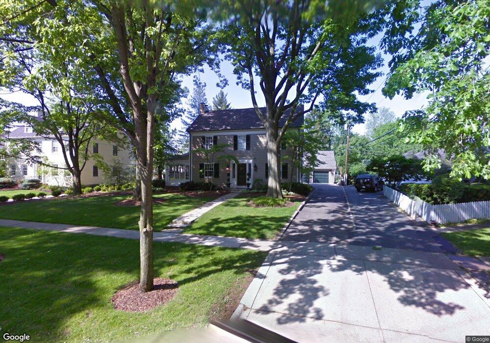
2025 Tremont Rd Columbus, OH 43221
Estimated Value: $1,403,000 - $1,598,000
4
Beds
4
Baths
3,384
Sq Ft
$444/Sq Ft
Est. Value
About This Home
This home is located at 2025 Tremont Rd, Columbus, OH 43221 and is currently estimated at $1,502,543, approximately $444 per square foot. 2025 Tremont Rd is a home located in Franklin County with nearby schools including Barrington Road Elementary School, Jones Middle School, and Upper Arlington High School.
Ownership History
Date
Name
Owned For
Owner Type
Purchase Details
Closed on
Jul 27, 2001
Sold by
Wiese John A
Bought by
Roe Daniel B and Roe Robin R
Current Estimated Value
Home Financials for this Owner
Home Financials are based on the most recent Mortgage that was taken out on this home.
Original Mortgage
$584,800
Outstanding Balance
$215,234
Interest Rate
6.37%
Mortgage Type
Purchase Money Mortgage
Estimated Equity
$1,287,309
Create a Home Valuation Report for This Property
The Home Valuation Report is an in-depth analysis detailing your home's value as well as a comparison with similar homes in the area
Home Values in the Area
Average Home Value in this Area
Purchase History
| Date | Buyer | Sale Price | Title Company |
|---|---|---|---|
| Roe Daniel B | -- | Chicago Title | |
| Wiese John A | $731,000 | Chicago Title |
Source: Public Records
Mortgage History
| Date | Status | Borrower | Loan Amount |
|---|---|---|---|
| Open | Wiese John A | $584,800 | |
| Closed | Roe Daniel B | $584,800 |
Source: Public Records
Tax History Compared to Growth
Tax History
| Year | Tax Paid | Tax Assessment Tax Assessment Total Assessment is a certain percentage of the fair market value that is determined by local assessors to be the total taxable value of land and additions on the property. | Land | Improvement |
|---|---|---|---|---|
| 2024 | $32,893 | $380,350 | $155,680 | $224,670 |
| 2023 | $21,766 | $380,350 | $155,680 | $224,670 |
| 2022 | $33,046 | $326,560 | $107,210 | $219,350 |
| 2021 | $20,215 | $326,560 | $107,210 | $219,350 |
| 2020 | $20,037 | $326,560 | $107,210 | $219,350 |
| 2019 | $20,087 | $289,460 | $107,210 | $182,250 |
| 2018 | $19,274 | $289,460 | $107,210 | $182,250 |
| 2017 | $19,426 | $289,460 | $107,210 | $182,250 |
| 2016 | $18,606 | $281,410 | $100,140 | $181,270 |
| 2015 | $18,590 | $281,410 | $100,140 | $181,270 |
| 2014 | $18,495 | $279,660 | $100,140 | $179,520 |
| 2013 | $8,832 | $254,240 | $91,035 | $163,205 |
Source: Public Records
Map
Nearby Homes
- 2009 N Devon Rd
- 2295 Oxford Rd
- 1932 Suffolk Rd Unit 1932
- 1934 Bedford Rd
- 2063 Westover Rd
- 2357 Keep Place Unit 2357
- 1631 Roxbury Rd Unit D2
- 1631 Roxbury Rd Unit A1
- 1631 Roxbury Rd Unit B6
- 2015 W 5th Ave Unit 211
- 2015 W 5th Ave Unit 102
- 2015 W 5th Ave Unit 108
- 2110 Northwest Blvd
- 2276 Northwest Blvd
- 1659 Tremont Rd
- 1733 Elmwood Ave
- 1729 Elmwood Ave
- 1561 Glenn Ave
- 1661 Ashland Ave Unit 663
- 1655-1657 Ashland Ave
- 2015 Tremont Rd
- 2035 Tremont Rd
- 2079 Guilford Rd
- 2001 Tremont Rd
- 2089 Guilford Rd
- 2056 Waltham Rd
- 2006 Cambridge Blvd
- 1988 Cambridge Blvd
- 2099 Guilford Rd
- 2064 Waltham Rd
- 2030 Tremont Rd
- 2020 Tremont Rd
- 2040 Tremont Rd
- 2012 Tremont Rd
- 2030 Cambridge Blvd
- 2050 Tremont Rd
- 1960 Cambridge Blvd
- 2065 Tremont Rd
- 2090 Guilford Rd
- 0 Cambridge Blvd