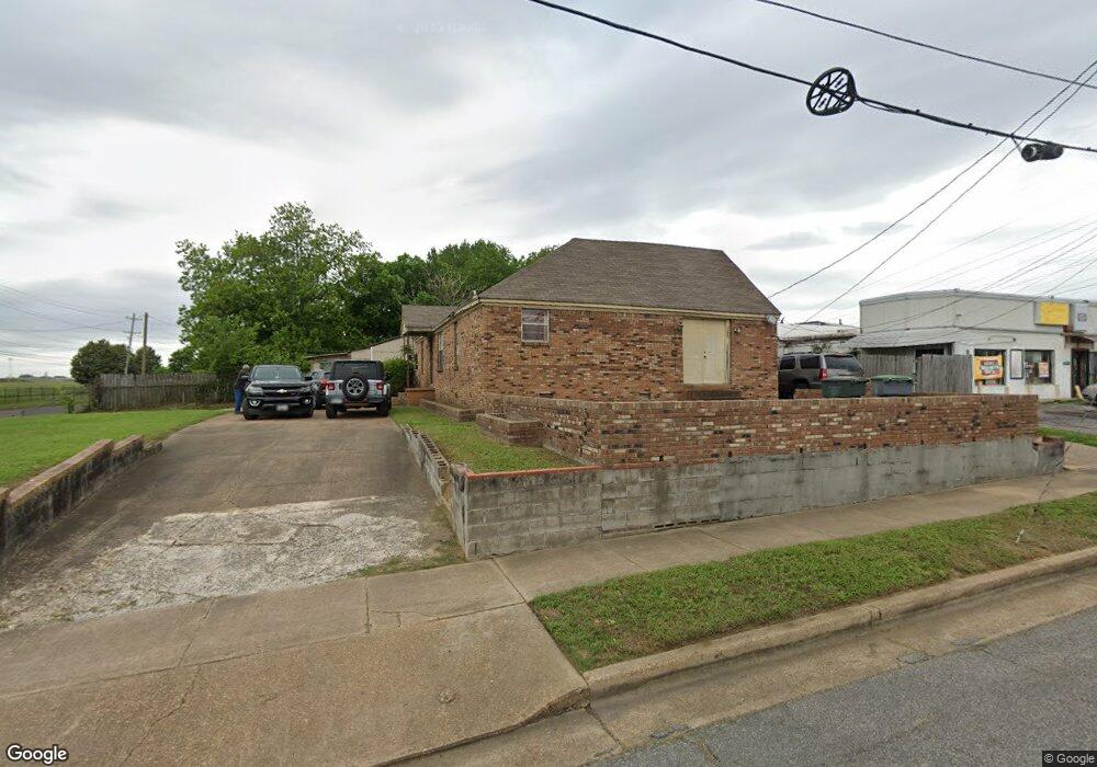
2026 Dunn Ave Memphis, TN 38114
Southeast Memphis NeighborhoodEstimated Value: $106,000 - $171,000
5
Beds
3
Baths
2,292
Sq Ft
$58/Sq Ft
Est. Value
About This Home
This home is located at 2026 Dunn Ave, Memphis, TN 38114 and is currently estimated at $133,139, approximately $58 per square foot. 2026 Dunn Ave is a home located in Shelby County with nearby schools including Hamilton High School, Memphis College Preparatory, and Veritas College Preparatory.
Ownership History
Date
Name
Owned For
Owner Type
Purchase Details
Closed on
Jan 9, 2019
Sold by
Commercial Band And Trust Company
Bought by
Edwards Myron
Current Estimated Value
Purchase Details
Closed on
Jun 2, 2007
Sold by
Edwards Monroe J
Bought by
Edwards Monroe J and Monroe J Edwards Living Trust
Purchase Details
Closed on
May 16, 2006
Sold by
Edwards Bessie Murphy
Bought by
Edwards Monroe J
Create a Home Valuation Report for This Property
The Home Valuation Report is an in-depth analysis detailing your home's value as well as a comparison with similar homes in the area
Home Values in the Area
Average Home Value in this Area
Purchase History
| Date | Buyer | Sale Price | Title Company |
|---|---|---|---|
| Edwards Myron | -- | None Available | |
| Edwards Monroe J | -- | None Available | |
| Edwards Monroe J | $84,446 | First Natl Fincl Title Svcs |
Source: Public Records
Tax History Compared to Growth
Tax History
| Year | Tax Paid | Tax Assessment Tax Assessment Total Assessment is a certain percentage of the fair market value that is determined by local assessors to be the total taxable value of land and additions on the property. | Land | Improvement |
|---|---|---|---|---|
| 2025 | $661 | $20,125 | $1,500 | $18,625 |
| 2024 | $661 | $19,500 | $1,000 | $18,500 |
| 2023 | $1,188 | $19,500 | $1,000 | $18,500 |
| 2022 | $1,188 | $19,500 | $1,000 | $18,500 |
| 2021 | $673 | $19,500 | $1,000 | $18,500 |
| 2020 | $1,047 | $14,450 | $1,000 | $13,450 |
| 2019 | $462 | $14,450 | $1,000 | $13,450 |
| 2018 | $462 | $14,450 | $1,000 | $13,450 |
| 2017 | $473 | $14,450 | $1,000 | $13,450 |
| 2016 | $653 | $14,950 | $0 | $0 |
| 2014 | $653 | $14,950 | $0 | $0 |
Source: Public Records
Map
Nearby Homes
- 1949 Lapaloma St
- 1817 S Barksdale St
- 0 Airways Blvd Unit 10199303
- 1936 Frisco Ave
- 1971 Boyle Ave
- 1720 Airways Blvd
- 2151 Goff Ave
- 1832 Rozelle St
- 1824 Rozelle St
- 2149 Wabash Ave
- 1059 S Willett St S
- 2400 Kimball Ave
- 2383 Lowell Ave
- 0 Dublin Ave Unit LOTS 20 & 21 LAST TW
- 996 Rozelle St
- 2481 Kimball Ave
- 2235 Charjean Rd
- 1560 Cane Rd
- 2196 Ketchum Rd
- 1998 Cloverdale Dr
- 2018 Dunn Ave
- 2012 Dunn Ave
- 2004 Dunn Ave
- 1939 Castalia St Unit 9
- 1939 Castalia St
- 1927 Castalia St
- 1998 Dunn Ave
- 1992 Dunn Ave
- 1995 Murley Ave
- 1984 Dunn Ave
- 1987 Murley Ave
- 1976 Dunn Ave
- 1983 Murley Ave
- 1992 Murley Ave
- 1977 Murley Ave
- 1970 Dunn Ave
- 1984 Murley Ave
- 1971 Murley Ave
- 1978 Murley Ave
- 1909 Castalia St