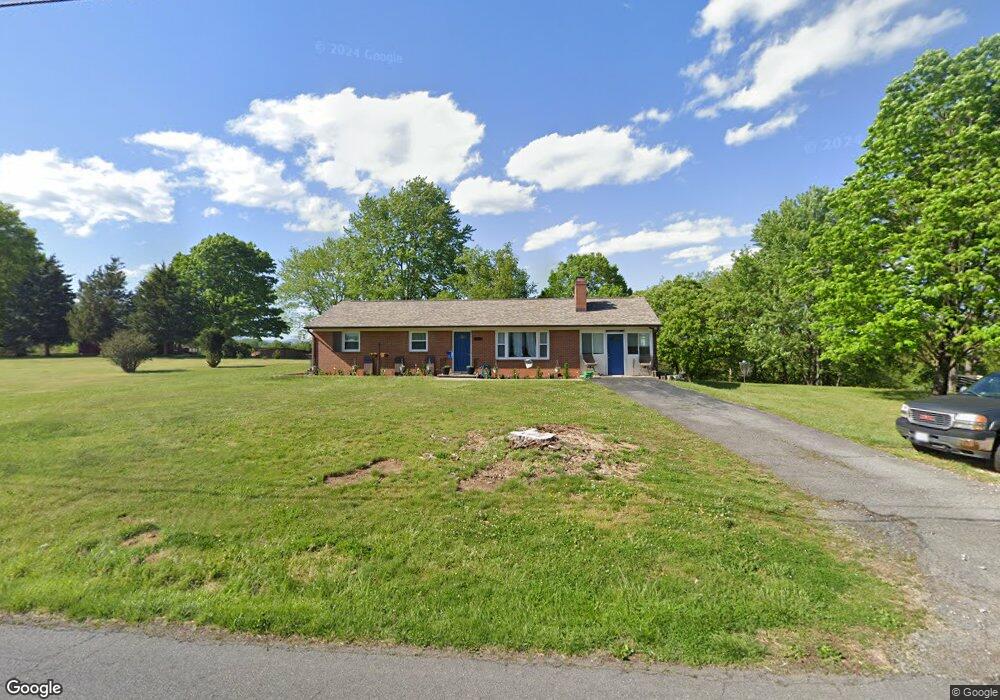
2026 Mayfield Dr Roanoke, VA 24014
Estimated Value: $255,000 - $286,000
3
Beds
1
Bath
1,196
Sq Ft
$226/Sq Ft
Est. Value
About This Home
This home is located at 2026 Mayfield Dr, Roanoke, VA 24014 and is currently estimated at $270,462, approximately $226 per square foot. 2026 Mayfield Dr is a home located in Roanoke County with nearby schools including Mt. Pleasant Elementary School, William Byrd Middle School, and William Byrd High School.
Ownership History
Date
Name
Owned For
Owner Type
Purchase Details
Closed on
Jul 9, 2018
Sold by
Thacker Earl Dean and Jennings Robyn D
Bought by
Atwood Alex C and Calevro Vanessa L
Current Estimated Value
Purchase Details
Closed on
Mar 16, 2009
Sold by
Bank Of New York Mellon
Bought by
Thacker Earl Dean and Jennings Robyn D
Purchase Details
Closed on
Nov 18, 2008
Sold by
Clark Kathy Denise
Bought by
The Bank Of New York Mellon
Create a Home Valuation Report for This Property
The Home Valuation Report is an in-depth analysis detailing your home's value as well as a comparison with similar homes in the area
Home Values in the Area
Average Home Value in this Area
Purchase History
| Date | Buyer | Sale Price | Title Company |
|---|---|---|---|
| Atwood Alex C | $152,000 | Fidelity National Title Insu | |
| Thacker Earl Dean | $96,000 | Century Title Services Inc | |
| The Bank Of New York Mellon | $113,308 | None Available |
Source: Public Records
Tax History Compared to Growth
Tax History
| Year | Tax Paid | Tax Assessment Tax Assessment Total Assessment is a certain percentage of the fair market value that is determined by local assessors to be the total taxable value of land and additions on the property. | Land | Improvement |
|---|---|---|---|---|
| 2025 | $2,423 | $235,200 | $40,500 | $194,700 |
| 2024 | $2,285 | $219,700 | $40,500 | $179,200 |
| 2023 | $2,054 | $193,800 | $40,500 | $153,300 |
| 2022 | $1,760 | $161,500 | $32,400 | $129,100 |
| 2021 | $1,598 | $146,600 | $27,900 | $118,700 |
| 2020 | $1,552 | $142,400 | $27,900 | $114,500 |
| 2019 | $1,451 | $133,100 | $24,800 | $108,300 |
| 2018 | $1,416 | $130,900 | $24,800 | $106,100 |
| 2017 | $1,416 | $129,900 | $24,800 | $105,100 |
| 2016 | $1,402 | $128,600 | $24,800 | $103,800 |
| 2015 | $1,404 | $128,800 | $24,800 | $104,000 |
| 2014 | $1,390 | $127,500 | $24,800 | $102,700 |
Source: Public Records
Map
Nearby Homes
- 1701 Mayfield Dr
- 1313 Ashebrook Dr
- 3036 Woodway Rd
- 3091 Pitzer Rd
- 3523 Bandy Rd
- 1631 Eanes Rd
- 1523 Rosewalk Ln
- 2602 Mount Pleasant Blvd SE
- 1320 Eddington Rd SE
- 1486 Craig Robertson Rd SE
- 0 Garden City Blvd SE
- 0 Ventnor Rd SE Unit 922423
- 3112 Garden City Blvd SE
- 3121 Trent Rd SE Unit & 3123
- 3716 Ventnor Rd SE
- 3520 Ballyhack Trail
- 3540 Ballyhack Trail
- 1130 Ethel Rd SE
- 3709 Garden City Blvd SE
- 3592 Ballyhack Trail
- 2114 Mayfield Dr
- 2025 Mayfield Dr
- 2105 Mayfield Dr
- 2013 Mayfield Dr
- 0 Mayfield Dr
- 2006 Mayfield Dr
- 3251 Bushdale Rd
- 2124 Mayfield Dr
- 2125 Mayfield Dr
- 3330 Alcoa Rd
- 1919 Mayfield Dr
- 3333 Alcoa Rd
- 1920 Mayfield Dr
- 3143 Bushdale Rd
- 2204 Mayfield Dr
- 3509 Bushdale Rd
- 2201 Mayfield Dr
- 3336 Alcoa Rd
- 2212 Mayfield Dr
- 1915 Mayfield Dr