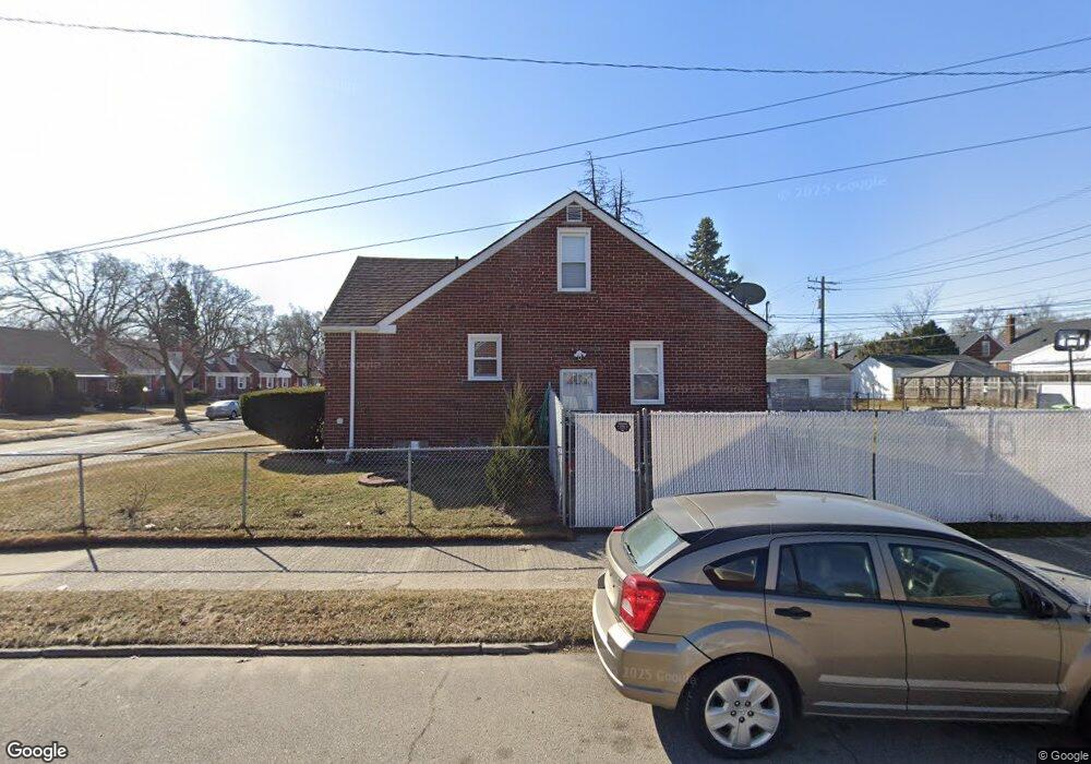
20261 Mitchell St Detroit, MI 48234
Butler NeighborhoodEstimated Value: $73,493 - $102,000
3
Beds
1
Bath
1,115
Sq Ft
$78/Sq Ft
Est. Value
About This Home
This home is located at 20261 Mitchell St, Detroit, MI 48234 and is currently estimated at $87,373, approximately $78 per square foot. 20261 Mitchell St is a home located in Wayne County with nearby schools including Nolan Elementary/Middle School, Edward 'Duke' Ellington Conservatory of Music and Art, and Charles L. Spain Elementary-Middle School.
Ownership History
Date
Name
Owned For
Owner Type
Purchase Details
Closed on
Mar 16, 2009
Sold by
Secretary Of Housing & Urban Development
Bought by
Martin Sausha
Current Estimated Value
Purchase Details
Closed on
Jul 3, 2008
Sold by
Wells Fargo Bank Na
Bought by
Hud
Purchase Details
Closed on
Jan 2, 2008
Sold by
Hunt Adam C C and Hunt Lanail
Bought by
Wells Fargo Bank Na
Create a Home Valuation Report for This Property
The Home Valuation Report is an in-depth analysis detailing your home's value as well as a comparison with similar homes in the area
Home Values in the Area
Average Home Value in this Area
Purchase History
| Date | Buyer | Sale Price | Title Company |
|---|---|---|---|
| Martin Sausha | $6,000 | None Available | |
| Hud | -- | None Available | |
| Wells Fargo Bank Na | $70,909 | None Available |
Source: Public Records
Tax History
| Year | Tax Paid | Tax Assessment Tax Assessment Total Assessment is a certain percentage of the fair market value that is determined by local assessors to be the total taxable value of land and additions on the property. | Land | Improvement |
|---|---|---|---|---|
| 2025 | $795 | $25,600 | $0 | $0 |
| 2024 | $797 | $21,800 | $0 | $0 |
| 2023 | $772 | $17,500 | $0 | $0 |
| 2022 | $835 | $14,700 | $0 | $0 |
| 2021 | $750 | $11,700 | $0 | $0 |
| 2020 | $809 | $10,100 | $0 | $0 |
| 2019 | $1,065 | $8,100 | $0 | $0 |
| 2018 | $696 | $7,800 | $0 | $0 |
| 2017 | $144 | $7,600 | $0 | $0 |
| 2016 | $1,189 | $21,600 | $0 | $0 |
| 2015 | $1,580 | $15,800 | $0 | $0 |
| 2013 | $1,977 | $19,770 | $0 | $0 |
| 2010 | -- | $28,985 | $1,508 | $27,477 |
Source: Public Records
Map
Nearby Homes
- 23428 Harned St Unit 2
- 23420 Harned St Unit 1
- 23485 Harned St Unit 10
- 20037 Gallagher St
- 19988 Harned St
- 19958 Harned St
- 19974 Charest St
- 20021 Mackay St
- 20506 Revere St
- 20409 Yonka St
- 20048 Fleming St
- 20120 Norwood St
- 2746 John B Ave
- 20161 Yonka St
- 2615 Emmons Ave
- 19936 Goddard St
- 20181 Lumpkin St
- 20426 Wexford St
- 19694 Gallagher St
- 19665 Charest St
- 20253 Mitchell St
- 20245 Mitchell St
- 20401 Mitchell St
- 20237 Mitchell St
- 20264 Harned St
- 20411 Mitchell St
- 20254 Harned St
- 20244 Harned St
- 20260 Mitchell St
- 20400 Harned St
- 20229 Mitchell St
- 20250 Mitchell St
- 20417 Mitchell St
- 20402 Mitchell St
- 20244 Mitchell St
- 20234 Harned St
- 20410 Harned St
- 20410 Mitchell St
- 20221 Mitchell St
- 20234 Mitchell St
Your Personal Tour Guide
Ask me questions while you tour the home.