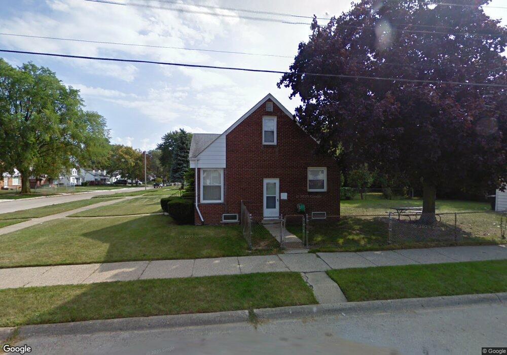
20265 Anglin St Detroit, MI 48234
Butler NeighborhoodEstimated Value: $63,000 - $82,000
--
Bed
1
Bath
975
Sq Ft
$75/Sq Ft
Est. Value
About This Home
This home is located at 20265 Anglin St, Detroit, MI 48234 and is currently estimated at $73,432, approximately $75 per square foot. 20265 Anglin St is a home located in Wayne County with nearby schools including Nolan Elementary/Middle School, Edward 'Duke' Ellington Conservatory of Music and Art, and Charles L. Spain Elementary-Middle School.
Ownership History
Date
Name
Owned For
Owner Type
Purchase Details
Closed on
May 28, 2021
Sold by
Asc Investment Venture Group Llc
Bought by
Hill Anthony and Hill Carmen
Current Estimated Value
Purchase Details
Closed on
Sep 20, 2013
Sold by
Hill Anthony and Hill Carmen
Bought by
Asc Investment Venture Group Llc
Purchase Details
Closed on
Mar 21, 2013
Sold by
Hill Anthony and Hill Carmen
Bought by
Jpmorgan Chase Bank Na
Purchase Details
Closed on
Jan 10, 2005
Sold by
Pongonis Richard T and Pongonis Eleanor L
Bought by
Hill Anthony
Create a Home Valuation Report for This Property
The Home Valuation Report is an in-depth analysis detailing your home's value as well as a comparison with similar homes in the area
Home Values in the Area
Average Home Value in this Area
Purchase History
| Date | Buyer | Sale Price | Title Company |
|---|---|---|---|
| Hill Anthony | -- | None Available | |
| Asc Investment Venture Group Llc | $12,600 | Excel Title Agency Llc | |
| Jpmorgan Chase Bank Na | $7,351 | None Available | |
| Hill Anthony | $78,000 | Commonwealth Land Title |
Source: Public Records
Tax History Compared to Growth
Tax History
| Year | Tax Paid | Tax Assessment Tax Assessment Total Assessment is a certain percentage of the fair market value that is determined by local assessors to be the total taxable value of land and additions on the property. | Land | Improvement |
|---|---|---|---|---|
| 2025 | $848 | $27,700 | $0 | $0 |
| 2024 | $848 | $23,600 | $0 | $0 |
| 2023 | $821 | $18,900 | $0 | $0 |
| 2022 | $770 | $16,300 | $0 | $0 |
| 2021 | $1,175 | $13,000 | $0 | $0 |
| 2020 | $862 | $11,100 | $0 | $0 |
| 2019 | $850 | $8,900 | $0 | $0 |
| 2018 | $738 | $8,600 | $0 | $0 |
| 2017 | $157 | $8,300 | $0 | $0 |
| 2016 | $1,146 | $23,800 | $0 | $0 |
| 2015 | $1,500 | $15,000 | $0 | $0 |
| 2013 | $1,878 | $18,779 | $0 | $0 |
| 2010 | -- | $27,533 | $1,519 | $26,014 |
Source: Public Records
Map
Nearby Homes
- 23421 Harned St Unit 4
- 23429 Harned St Unit 5
- 23485 Harned St Unit 10
- 23420 Harned St Unit 1
- 20121 Mitchell St
- 20021 Mackay St
- 20048 Fleming St
- 20181 Lumpkin St
- 20021 Fleming St
- 19951 Mackay St
- 19958 Harned St
- 20156 Gallagher St
- 20491 Klinger St
- 20037 Gallagher St
- 19948 Mitchell St
- 20028 Gallagher St
- 20209 Revere St
- 2059 Emmons Ave
- 20138 Norwood St
- 20120 Norwood St
- 20264 Mackay St
- 20254 Mackay St
- 20400 Mackay St
- 20255 Anglin St
- 20245 Anglin St
- 20244 Mackay St
- 20410 Mackay St
- 20413 Anglin St
- 20234 Mackay St
- 20235 Anglin St
- 20420 Mackay St
- 20421 Anglin St
- 20431 Anglin St
- 20226 Mackay St
- 20225 Anglin St
- 20428 Mackay St
- 20267 Mackay St
- 20215 Anglin St
- 20438 Mackay St
- 20257 Mackay St