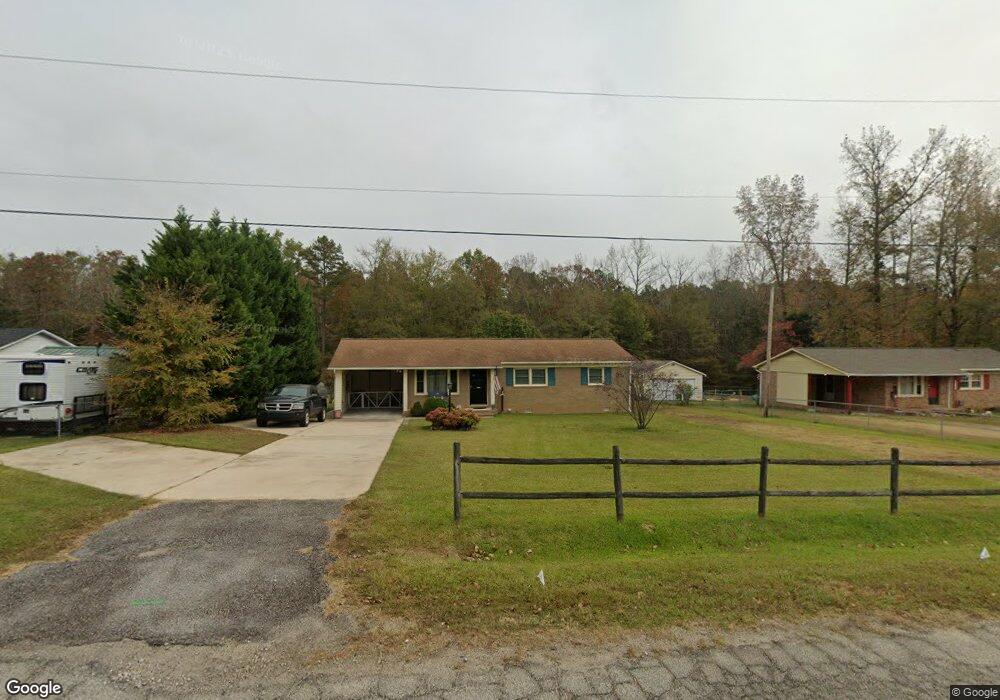
2028 Williams Cir Lancaster, SC 29720
Estimated Value: $142,723 - $205,000
Studio
1
Bath
1,395
Sq Ft
$128/Sq Ft
Est. Value
About This Home
This home is located at 2028 Williams Cir, Lancaster, SC 29720 and is currently estimated at $177,931, approximately $127 per square foot. 2028 Williams Cir is a home located in Lancaster County with nearby schools including Erwin Elementary School, South Middle School, and Lancaster High School.
Ownership History
Date
Name
Owned For
Owner Type
Purchase Details
Closed on
Oct 26, 2018
Sold by
Jenkins Richard and Jenkins Cathy Diane
Bought by
Clemmer Teresa and Jenkins James T
Current Estimated Value
Purchase Details
Closed on
Nov 28, 2017
Sold by
Estate Of Josephine Sinclair Jenkins
Bought by
Clemmer Teresa and Jenkins Cathy Diane
Purchase Details
Closed on
Aug 23, 2013
Sold by
Jenkins James Thoms
Bought by
Jenkins Josephine
Purchase Details
Closed on
Feb 24, 2006
Sold by
Jenkins Josephine
Bought by
Jenkins James Thomas
Create a Home Valuation Report for This Property
The Home Valuation Report is an in-depth analysis detailing your home's value as well as a comparison with similar homes in the area
Home Values in the Area
Average Home Value in this Area
Purchase History
| Date | Buyer | Sale Price | Title Company |
|---|---|---|---|
| Clemmer Teresa | -- | None Available | |
| Clemmer Teresa | -- | None Available | |
| Jenkins Josephine | -- | -- | |
| Jenkins James Thomas | -- | None Available | |
| Jenkins Josephine | -- | None Available |
Source: Public Records
Tax History
| Year | Tax Paid | Tax Assessment Tax Assessment Total Assessment is a certain percentage of the fair market value that is determined by local assessors to be the total taxable value of land and additions on the property. | Land | Improvement |
|---|---|---|---|---|
| 2024 | $522 | $3,400 | $404 | $2,996 |
| 2023 | $520 | $3,400 | $404 | $2,996 |
| 2022 | $518 | $3,400 | $404 | $2,996 |
| 2021 | $507 | $3,400 | $404 | $2,996 |
| 2020 | $504 | $3,288 | $404 | $2,884 |
| 2019 | $1,113 | $3,288 | $404 | $2,884 |
| 2018 | $1,071 | $3,288 | $404 | $2,884 |
| 2017 | $193 | $0 | $0 | $0 |
| 2016 | $188 | $0 | $0 | $0 |
| 2015 | $357 | $0 | $0 | $0 |
| 2014 | $357 | $0 | $0 | $0 |
| 2013 | $357 | $0 | $0 | $0 |
Source: Public Records
Map
Nearby Homes
- 1795 Grace Ave
- 1746 Grace Ave Unit 1
- 1428 Boxwood Ave
- 1519 Oakwood Ave
- 1801 Grace Ave
- 1500 Victoria St Unit 4
- 1509 Victoria St Unit 13
- 1503 Victoria St
- 1817 Grace Ave
- 1501 Victoria St Unit 11
- 1250 Hampton Grace Ave
- 1841 Grace Ave
- 2067 Great Falls Hwy
- 5.45 acres Memorial Park Rd
- 3.04 acres Memorial Park Rd
- 1613 Small St
- 1227 Laurel Ave
- 1744 Old Charles St Unit 54
- 00 Airport Rd
- 1337 Old Greenbriar Dr
- 2020 Williams Cir
- 2038 Williams Cir
- 2012 Williams Cir
- 2052 Williams Cir
- 1669 Kaywood Dr
- 1661 Kaywood Dr
- 1662 Grace Ave
- 1798 Drywood Cir
- 2060 Williams Cir
- 1653 Kaywood Dr
- 1797 Drywood Cir
- 1645 Kaywood Dr
- 1790 Drywood Cir
- 2068 Williams Cir
- 1988 Williams Cir
- 1635 Kaywood Dr
- 1977 Williams Cir
- 1782 Drywood Cir
- 2076 Williams Cir
- 1651 Drywood Cir
Your Personal Tour Guide
Ask me questions while you tour the home.