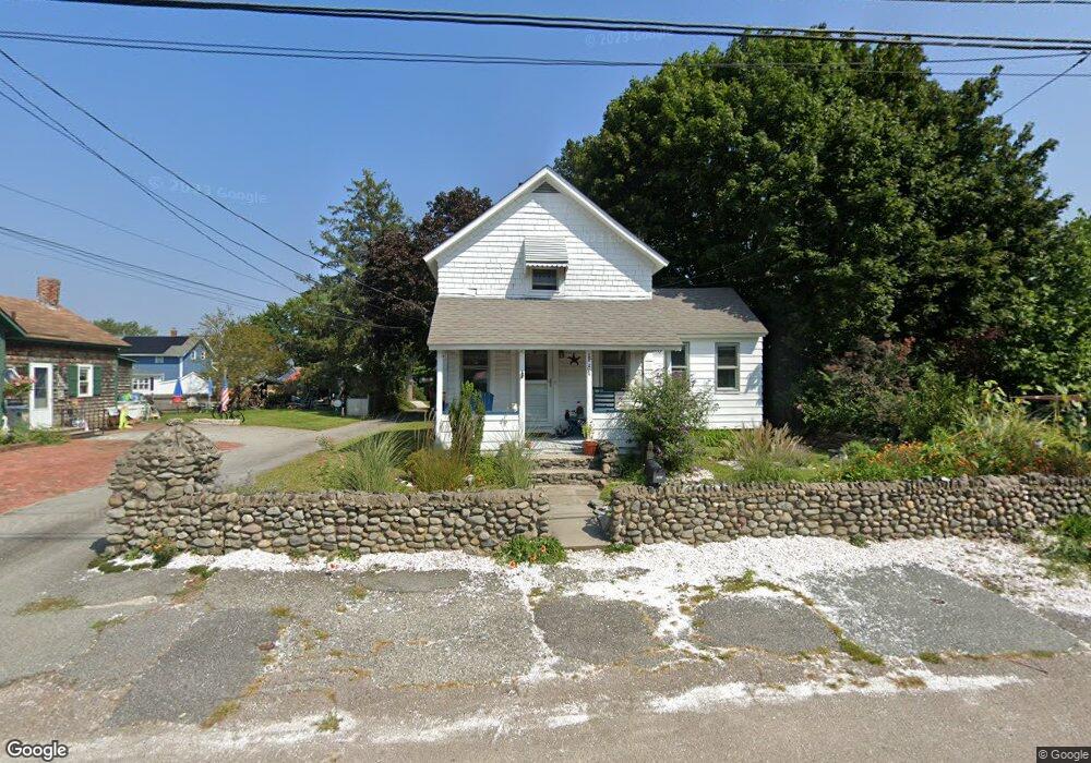
203 Bay Spring Ave Barrington, RI 02806
Bay Spring NeighborhoodEstimated Value: $385,719 - $458,000
3
Beds
1
Bath
837
Sq Ft
$506/Sq Ft
Est. Value
About This Home
This home is located at 203 Bay Spring Ave, Barrington, RI 02806 and is currently estimated at $423,430, approximately $505 per square foot. 203 Bay Spring Ave is a home located in Bristol County with nearby schools including Barrington High School, St Luke Elementary School, and Barrington Christian Academy.
Ownership History
Date
Name
Owned For
Owner Type
Purchase Details
Closed on
Sep 26, 2007
Sold by
Kee Douglas and Kee Norman
Bought by
Rejto Michael J
Current Estimated Value
Home Financials for this Owner
Home Financials are based on the most recent Mortgage that was taken out on this home.
Original Mortgage
$200,000
Outstanding Balance
$127,721
Interest Rate
6.65%
Mortgage Type
Purchase Money Mortgage
Estimated Equity
$295,709
Create a Home Valuation Report for This Property
The Home Valuation Report is an in-depth analysis detailing your home's value as well as a comparison with similar homes in the area
Home Values in the Area
Average Home Value in this Area
Purchase History
| Date | Buyer | Sale Price | Title Company |
|---|---|---|---|
| Rejto Michael J | $250,000 | -- |
Source: Public Records
Mortgage History
| Date | Status | Borrower | Loan Amount |
|---|---|---|---|
| Open | Rejto Michael J | $25,000 | |
| Closed | Rejto Michael J | $12,500 | |
| Open | Rejto Michael J | $200,000 |
Source: Public Records
Tax History Compared to Growth
Tax History
| Year | Tax Paid | Tax Assessment Tax Assessment Total Assessment is a certain percentage of the fair market value that is determined by local assessors to be the total taxable value of land and additions on the property. | Land | Improvement |
|---|---|---|---|---|
| 2025 | $4,525 | $295,000 | $219,000 | $76,000 |
| 2024 | $4,351 | $295,000 | $219,000 | $76,000 |
| 2023 | $4,365 | $215,000 | $144,000 | $71,000 |
| 2022 | $4,225 | $215,000 | $144,000 | $71,000 |
| 2021 | $4,117 | $215,000 | $144,000 | $71,000 |
| 2020 | $3,825 | $183,000 | $119,000 | $64,000 |
| 2019 | $3,678 | $183,000 | $119,000 | $64,000 |
| 2018 | $3,569 | $183,000 | $119,000 | $64,000 |
| 2017 | $3,604 | $180,200 | $112,300 | $67,900 |
| 2016 | $3,325 | $180,200 | $112,300 | $67,900 |
| 2015 | $3,289 | $180,200 | $112,300 | $67,900 |
| 2014 | $3,698 | $202,100 | $112,300 | $89,800 |
Source: Public Records
Map
Nearby Homes
- 164 Bay Spring Ave
- 29 Lake Ave
- 25 Park Square Ave
- 299 Narragansett Ave
- 140 Promenade St
- 0 Carousel Dr
- 4 Spinnaker Dr
- 0 Bogman Rd
- 45 Washington Rd
- 5 Booth Ave
- 1 3rd St
- 20 Townsend St
- 85 Hilton Ave
- 27 Rosedale Ave
- 7 Carpenter Ave
- 81 Pine Crest Dr
- 83 Pine Crest Dr
- 16 Highview Ave
- 150 Alfred Drowne Rd
- 41 White Ave
- 139 Narragansett Ave
- 139 Narragansett Ave Unit 1
- 9 Leslie Ave
- 143 Narragansett Ave
- 15 Leslie Ave
- 201 Bay Spring Ave
- 11 Leslie Ave
- 207 Bay Spring Ave
- 17 Leslie Ave
- 12 Allen Ave
- 20 Allen Ave
- 195 Bay Spring Ave
- 127 Narragansett Ave
- 19 Leslie Ave
- 22 Allen Ave
- 7 Leslie Ave
- 149 Narragansett Ave
- 149 Narragansett Ave Unit C
- 26 Allen Ave
- 1 Leslie Ave