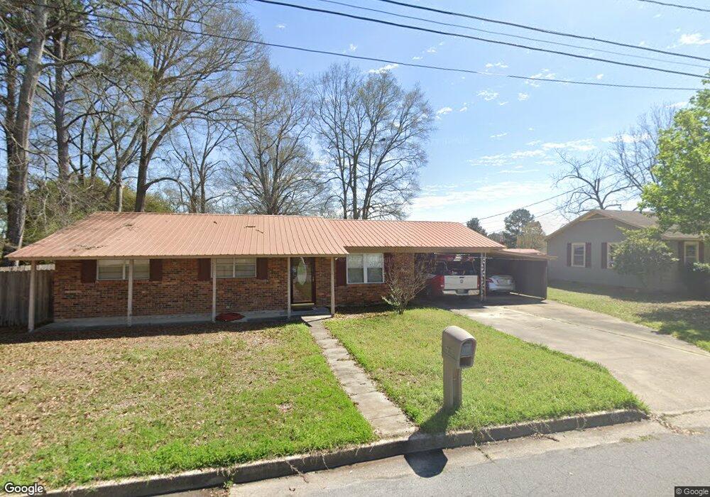
203 Brock Ave Quitman, MS 39355
Estimated Value: $74,242 - $132,000
Studio
--
Bath
1,338
Sq Ft
$78/Sq Ft
Est. Value
About This Home
This home is located at 203 Brock Ave, Quitman, MS 39355 and is currently estimated at $104,747, approximately $78 per square foot. 203 Brock Ave is a home located in Clarke County with nearby schools including Quitman Lower Elementary School, Quitman Upper Elementary School, and Quitman Junior High School.
Ownership History
Date
Name
Owned For
Owner Type
Purchase Details
Closed on
Dec 19, 2013
Sold by
Mcdonald Justin Stan and Mcdonald Jessica Stewart
Bought by
Grace Michael and Grace Emily
Current Estimated Value
Home Financials for this Owner
Home Financials are based on the most recent Mortgage that was taken out on this home.
Original Mortgage
$72,659
Outstanding Balance
$54,712
Interest Rate
4.4%
Mortgage Type
FHA
Estimated Equity
$50,035
Purchase Details
Closed on
Feb 4, 2009
Sold by
Elmore William Albert
Bought by
Mcdonald Justin Stan and Mcdonald Jessica Stewart
Create a Home Valuation Report for This Property
The Home Valuation Report is an in-depth analysis detailing your home's value as well as a comparison with similar homes in the area
Purchase History
| Date | Buyer | Sale Price | Title Company |
|---|---|---|---|
| Grace Michael | -- | -- | |
| Mcdonald Justin Stan | -- | -- |
Source: Public Records
Mortgage History
| Date | Status | Borrower | Loan Amount |
|---|---|---|---|
| Open | Grace Michael | $72,659 |
Source: Public Records
Tax History
| Year | Tax Paid | Tax Assessment Tax Assessment Total Assessment is a certain percentage of the fair market value that is determined by local assessors to be the total taxable value of land and additions on the property. | Land | Improvement |
|---|---|---|---|---|
| 2025 | $727 | $7,448 | $0 | $0 |
| 2024 | $721 | $7,448 | $0 | $0 |
| 2023 | $622 | $6,322 | $0 | $0 |
| 2022 | $622 | $6,322 | $0 | $0 |
| 2021 | $620 | $6,322 | $0 | $0 |
| 2020 | $621 | $6,322 | $0 | $0 |
| 2019 | $568 | $6,117 | $0 | $0 |
| 2018 | $542 | $6,117 | $0 | $0 |
| 2017 | $534 | $6,117 | $0 | $0 |
| 2016 | $522 | $6,117 | $0 | $0 |
| 2015 | -- | $4,688 | $0 | $0 |
| 2014 | -- | $4,688 | $0 | $0 |
Source: Public Records
Map
Nearby Homes
- TBA Mississippi 511
- 0 Mississippi 18
- 302 Mulberry Ln
- 500 E Church St
- 508 Betty Cir
- 109 Bailey Ave
- 137 Anderson St
- 215 N Jackson Ave
- 325 Cr 670
- 104 Carter St
- 218 Woodland Hills Dr
- 0 Cr 110 Unit 24-1212
- 117 Northwood Dr
- 226 County Road 683
- 177 County Road 1412
- 334 W of Co Rd
- 3395 Highway 145 N
- 292019 Highway 513
- 35 County Road 6901
- 129 County Road 146
- 205 Brock Ave
- 201 Brock Ave
- 200 Brock Ave
- 502 E Franklin St
- 422 E Franklin St
- 204 Brock Ave
- 206 Brock Ave
- 209 Brock Ave
- 501 E Franklin St
- 208 Brock Ave
- 420 E Franklin St
- 201 Case Ave
- 429 E Franklin St
- 503 E Franklin St
- 211 Brock Ave
- 506 E Franklin St
- 210 Brock Ave
- 427 E Franklin St
- 203 Case Ave
- 508 E Franklin St
Your Personal Tour Guide
Ask me questions while you tour the home.