
Seller's Agent in 2025
Karen Burnette
Porter Group Real Estate
(919) 920-5596
1 in this area
53 Total Sales
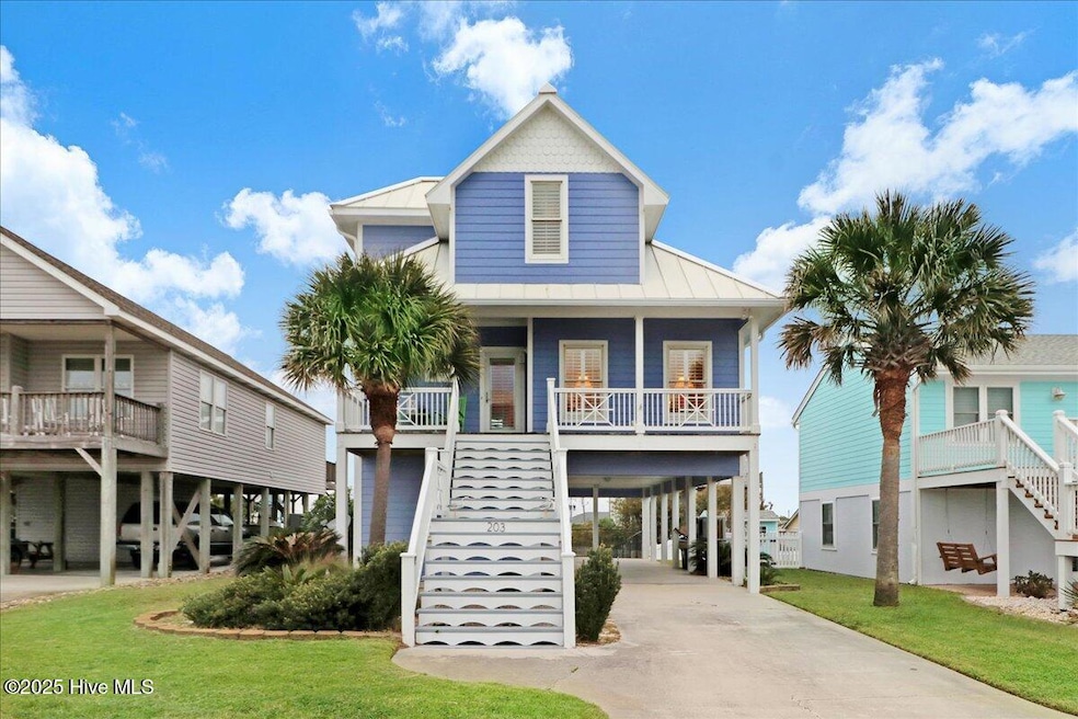


Escape to this elevated, charming 3-bedroom, 2.5-bath beach cottage where convenience meets coastal living. Unique features include an on-site elevator and the huge benefit of being located at one of the highest points in the area, meaning the owner has not had to purchase flood insurance! Only a couple of blocks from the ocean.The open-concept living space shines with a kitchen/dining area highlighted by vaulted pine ceilings, white cabinets, and warm pine floors, all bathed in light thanks to Andersen windows and classic plantation shutters. A master suite with a dedicated home office/study/flex room offers a private retreat.Enjoy peace of mind with a standing seam metal roof, two new condenser units and a fresh exterior, as the home was newly painted in 2024. Step outside to covered porches (front and back), a spacious storage/tackle room, and an essential outdoor shower after a day at the beach.Best of all, this property is offered fully furnished, making it truly move-in ready! You're just a short trip from local marinas, dining, and the sand and surf!
Last Agent to Sell the Property
Porter Group Real Estate License #303001 Listed on: 10/11/2025
| Date | Type | Sale Price | Title Company |
|---|---|---|---|
| Warranty Deed | $950,000 | None Listed On Document | |
| Special Warranty Deed | -- | None Available | |
| Trustee Deed | $311,175 | None Available | |
| Deed | $395,000 | -- | |
| Deed | $100,000 | -- |
| Date | Status | Loan Amount | Loan Type |
|---|---|---|---|
| Previous Owner | $307,600 | New Conventional |
| Date | Event | Price | List to Sale | Price per Sq Ft |
|---|---|---|---|---|
| 11/07/2025 11/07/25 | Sold | $950,000 | 0.0% | $546 / Sq Ft |
| 10/12/2025 10/12/25 | Pending | -- | -- | -- |
| 10/11/2025 10/11/25 | For Sale | $950,000 | -- | $546 / Sq Ft |
| Year | Tax Paid | Tax Assessment Tax Assessment Total Assessment is a certain percentage of the fair market value that is determined by local assessors to be the total taxable value of land and additions on the property. | Land | Improvement |
|---|---|---|---|---|
| 2025 | $2,144 | $909,362 | $278,953 | $630,409 |
| 2024 | $1,541 | $424,387 | $154,687 | $269,700 |
| 2023 | $1,458 | $424,387 | $154,687 | $269,700 |
| 2022 | $1,415 | $424,387 | $154,687 | $269,700 |
| 2021 | $1,415 | $424,387 | $154,687 | $269,700 |
| 2020 | $1,415 | $424,387 | $154,687 | $269,700 |
| 2019 | $971 | $308,465 | $90,562 | $217,903 |
| 2017 | $971 | $308,465 | $90,562 | $217,903 |
| 2016 | $971 | $308,465 | $90,562 | $217,903 |
| 2015 | $940 | $308,465 | $90,562 | $217,903 |
| 2014 | $1,150 | $378,348 | $130,952 | $247,396 |
Seller's Agent in 2025
Karen Burnette
Porter Group Real Estate
(919) 920-5596
1 in this area
53 Total Sales
Seller Co-Listing Agent in 2025
Lisa Dismore
Porter Group Real Estate
(919) 801-1087
1 in this area
63 Total Sales
Buyer's Agent in 2025
Pam Bird
Al Williams Properties
(252) 241-0160
40 in this area
169 Total Sales
Source: Hive MLS
MLS Number: 100535755
APN: 6385.13.03.5224000
Disclaimer: Certain information contained herein is derived from information provided by parties other than Homes.com. All information provided is deemed reliable, but is not guaranteed to be accurate and should be independently verified.
![]() The data relating to real estate on this web site comes in part from the Internet Data Exchange program of Hive MLS LLC. All information is deemed reliable but not guaranteed and should be independently verified. All properties are subject to prior sale, change, or withdrawal. Neither listing broker(s) nor Homesnap, Inc. shall be responsible for any typographical errors, misinformation, or misprints, and shall be held totally harmless from any damages arising from reliance upon these data. ©2026 Hive MLS LLC
The data relating to real estate on this web site comes in part from the Internet Data Exchange program of Hive MLS LLC. All information is deemed reliable but not guaranteed and should be independently verified. All properties are subject to prior sale, change, or withdrawal. Neither listing broker(s) nor Homesnap, Inc. shall be responsible for any typographical errors, misinformation, or misprints, and shall be held totally harmless from any damages arising from reliance upon these data. ©2026 Hive MLS LLC
Ask me questions while you tour the home.