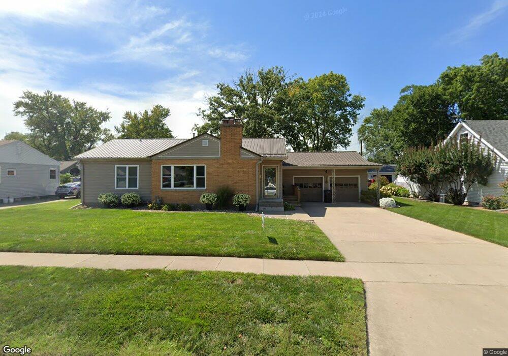
203 S Ferry St Ottumwa, IA 52501
Estimated Value: $148,000 - $182,219
2
Beds
4
Baths
1,285
Sq Ft
$122/Sq Ft
Est. Value
About This Home
This home is located at 203 S Ferry St, Ottumwa, IA 52501 and is currently estimated at $157,055, approximately $122 per square foot. 203 S Ferry St is a home located in Wapello County with nearby schools including Liberty Elementary School, Douma Elementary School, and Evans Middle School.
Ownership History
Date
Name
Owned For
Owner Type
Purchase Details
Closed on
Jul 11, 2022
Sold by
Palen Rochelle D and Palen Angie M
Bought by
Palen Coker Trust
Current Estimated Value
Purchase Details
Closed on
Sep 15, 2017
Sold by
Ludwig Demma
Bought by
Palen Rochelle D and Coker Angie M
Home Financials for this Owner
Home Financials are based on the most recent Mortgage that was taken out on this home.
Original Mortgage
$72,000
Interest Rate
3.89%
Mortgage Type
New Conventional
Create a Home Valuation Report for This Property
The Home Valuation Report is an in-depth analysis detailing your home's value as well as a comparison with similar homes in the area
Home Values in the Area
Average Home Value in this Area
Purchase History
| Date | Buyer | Sale Price | Title Company |
|---|---|---|---|
| Palen Coker Trust | -- | None Listed On Document | |
| Palen Rochelle D | -- | None Available |
Source: Public Records
Mortgage History
| Date | Status | Borrower | Loan Amount |
|---|---|---|---|
| Previous Owner | Palen Rochelle D | $72,000 |
Source: Public Records
Tax History Compared to Growth
Tax History
| Year | Tax Paid | Tax Assessment Tax Assessment Total Assessment is a certain percentage of the fair market value that is determined by local assessors to be the total taxable value of land and additions on the property. | Land | Improvement |
|---|---|---|---|---|
| 2025 | $3,022 | $157,830 | $14,160 | $143,670 |
| 2024 | $3,022 | $149,580 | $14,160 | $135,420 |
| 2023 | $2,654 | $149,580 | $14,160 | $135,420 |
| 2022 | $2,654 | $119,960 | $14,160 | $105,800 |
| 2021 | $2,867 | $112,930 | $14,160 | $98,770 |
| 2020 | $2,528 | $107,160 | $14,160 | $93,000 |
| 2019 | $2,590 | $107,160 | $0 | $0 |
| 2018 | $2,508 | $107,160 | $0 | $0 |
| 2017 | $2,554 | $106,760 | $0 | $0 |
| 2016 | $2,292 | $100,440 | $0 | $0 |
| 2015 | $2,296 | $100,440 | $0 | $0 |
| 2014 | $2,296 | $100,440 | $0 | $0 |
Source: Public Records
Map
Nearby Homes
- 138 Minnesota St
- 420 S Ferry St
- 1005 Hamilton St
- 117 Lynwood Ave
- 433 W Finley Ave
- 9 Kingsley Dr
- 1401 W Finley Ave
- 1410 W Finley Ave
- 314 Hamilton St
- 319 Hamilton St
- 513 Lynwood Cir
- 1508 Hamilton St
- 1018 W Mary St
- 404 W Mary St
- 120 Shaul Ave
- 522 S Adella St
- 0 S Webster Unit NOC6332429
- 00 S Webster St
- 434 S Ward St
- 448 Mckinley Ave
- 207 S Ferry St
- 137 S Ferry St
- 211 S Ferry St
- 133 S Ferry St
- 202 S Ferry St
- 142 S Ferry St
- 129 S Ferry St
- 138 S Ferry St
- 907 Glenwood Ave
- 822 Baldwin St
- 903 Glenwood Ave
- 134 S Ferry St
- 825 Glenwood Ave
- 125 S Ferry St
- 911 Glenwood Ave
- 130 S Ferry St
- 821 Glenwood Ave
- 817 Glenwood Ave
- 121 S Ferry St
- 126 S Ferry St