Estimated Value: $327,000 - $423,584
3
Beds
2
Baths
1,247
Sq Ft
$298/Sq Ft
Est. Value
About This Home
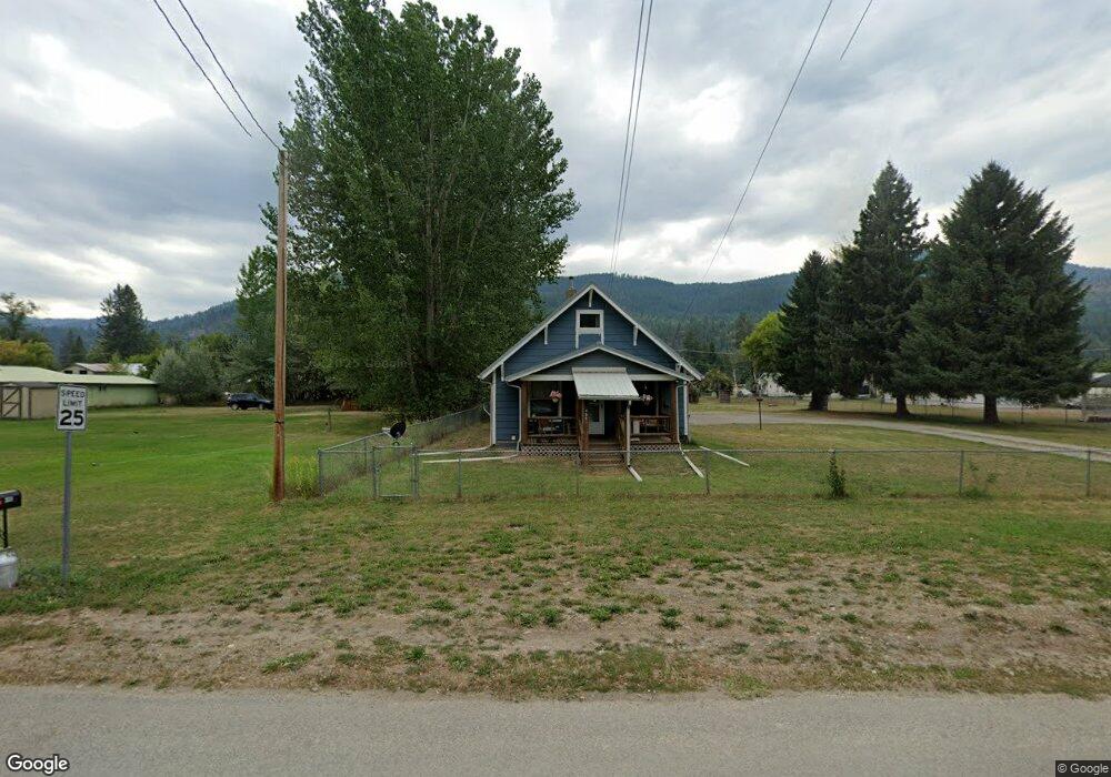
This home is located at 203 W Riverside Ave, Troy, MT 59935 and is currently estimated at $371,396, approximately $297 per square foot. 203 W Riverside Ave is a home located in Lincoln County with nearby schools including W.F. Morrison School, Troy Junior High School, and Troy High School.
Ownership History
Date
Name
Owned For
Owner Type
Purchase Details
Closed on
Sep 26, 2016
Sold by
Bowser Matthew J and Vestal Nia R
Bought by
Kathrein Dale
Current Estimated Value
Home Financials for this Owner
Home Financials are based on the most recent Mortgage that was taken out on this home.
Original Mortgage
$160,000
Outstanding Balance
$128,229
Interest Rate
3.45%
Mortgage Type
VA
Estimated Equity
$243,167
Create a Home Valuation Report for This Property
The Home Valuation Report is an in-depth analysis detailing your home's value as well as a comparison with similar homes in the area
Purchase History
| Date | Buyer | Sale Price | Title Company |
|---|---|---|---|
| Kathrein Dale | -- | First American Title Company |
Source: Public Records
Mortgage History
| Date | Status | Borrower | Loan Amount |
|---|---|---|---|
| Open | Kathrein Dale | $160,000 |
Source: Public Records
Tax History
| Year | Tax Paid | Tax Assessment Tax Assessment Total Assessment is a certain percentage of the fair market value that is determined by local assessors to be the total taxable value of land and additions on the property. | Land | Improvement |
|---|---|---|---|---|
| 2025 | $2,020 | $423,700 | $0 | $0 |
| 2024 | $2,652 | $324,104 | $0 | $0 |
| 2023 | $3,501 | $324,104 | $0 | $0 |
| 2022 | $1,760 | $175,700 | $0 | $0 |
| 2021 | $1,979 | $175,700 | $0 | $0 |
| 2020 | $1,562 | $124,500 | $0 | $0 |
| 2019 | $1,540 | $124,500 | $0 | $0 |
| 2018 | $1,978 | $158,600 | $0 | $0 |
| 2017 | $1,713 | $158,600 | $0 | $0 |
| 2016 | $1,336 | $108,900 | $0 | $0 |
| 2015 | $1,025 | $108,900 | $0 | $0 |
| 2014 | $989 | $56,021 | $0 | $0 |
Source: Public Records
Map
Nearby Homes
- 205 E Spokane Ave
- 716 Kootenai River Rd
- 210 E Missoula Ave
- 216 E Missoula Ave
- 312 Mineral Ave
- 106 N 6th St
- TBD E Dent Ave
- 514 E Grant Ave
- 707 E Grant Ave
- Parcel A N Kootenai Dr
- 1278 Hunts Mill Rd
- 420 St Regis Rd
- 12437 Us Highway 2
- Lot 1 River Rd
- 1720 River Rd
- 1268 Hunts Mill Rd
- 16995 Us Highway 2
- 181 Wapiti Way
- 818 Lake Creek Rd
- 984 S Side Rd
- 207 W Riverside Ave
- 215 W Riverside Ave
- 306 E Riverside Ave
- 205 Riverside Ave
- 105 W Riverside Ave
- 281 Riverside Ave
- 208 E Riverside Ave
- 362 Riverside Ave
- 275 Riverside Ave
- 275 Riverside Ave
- 276 Riverside Ave
- 101 W Riverside Ave
- 210 Mill Rd Troy
- 355 Riverside Ave
- 0 Riverside Ave
- 176 Mill Rd Unit LOT 2
- 176 Mill Rd Unit LOT 2 (Land Only)
- 232 E Mill Rd
- 210 Mill Rd
Your Personal Tour Guide
Ask me questions while you tour the home.