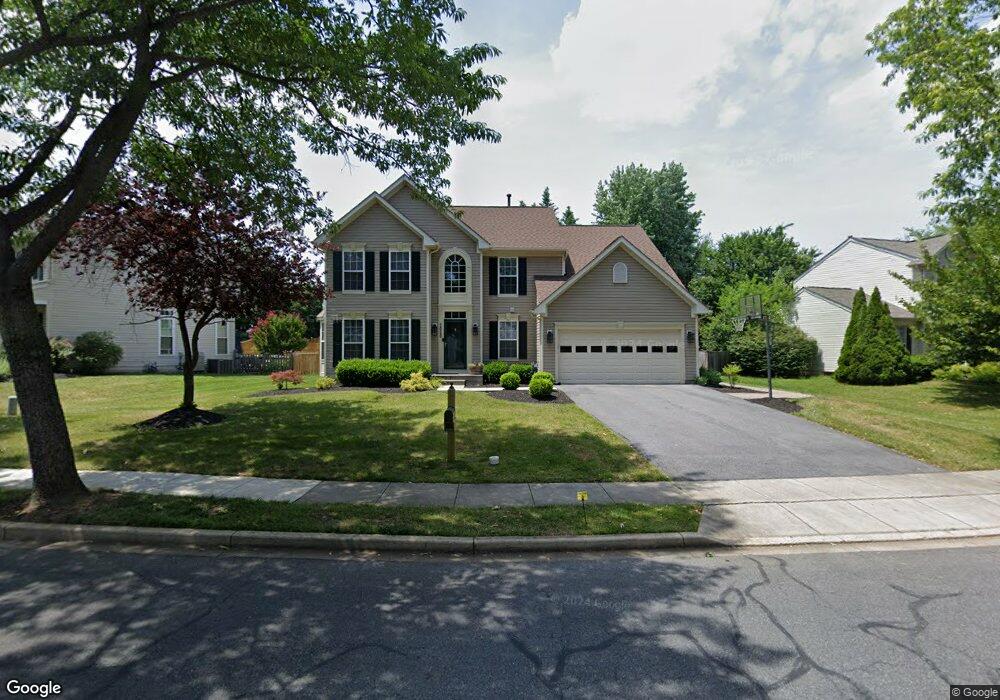
2030 Burnside Dr Frederick, MD 21702
Clover Hill NeighborhoodEstimated Value: $582,485 - $648,000
Studio
3
Baths
2,714
Sq Ft
$229/Sq Ft
Est. Value
About This Home
This home is located at 2030 Burnside Dr, Frederick, MD 21702 and is currently estimated at $620,871, approximately $228 per square foot. 2030 Burnside Dr is a home located in Frederick County with nearby schools including Monocacy Elementary School, Monocacy Middle School, and Gov. Thomas Johnson High School.
Ownership History
Date
Name
Owned For
Owner Type
Purchase Details
Closed on
Jun 21, 2021
Sold by
Harris Benjamin L and Harris Allison R
Bought by
Harris Benjamin L and Harris Allison R
Current Estimated Value
Purchase Details
Closed on
Oct 7, 1998
Sold by
Nvr Homes Inc
Bought by
Harris Benjamin L and Harris Allison R
Purchase Details
Closed on
Aug 12, 1998
Sold by
Frederick Farms Llc
Bought by
Nvr Homes Inc
Create a Home Valuation Report for This Property
The Home Valuation Report is an in-depth analysis detailing your home's value as well as a comparison with similar homes in the area
Home Values in the Area
Average Home Value in this Area
Purchase History
| Date | Buyer | Sale Price | Title Company |
|---|---|---|---|
| Harris Benjamin L | -- | None Available | |
| Harris Benjamin L | $215,769 | -- | |
| Nvr Homes Inc | $50,000 | -- |
Source: Public Records
Mortgage History
| Date | Status | Borrower | Loan Amount |
|---|---|---|---|
| Closed | Harris Benjamin L | -- |
Source: Public Records
Tax History
| Year | Tax Paid | Tax Assessment Tax Assessment Total Assessment is a certain percentage of the fair market value that is determined by local assessors to be the total taxable value of land and additions on the property. | Land | Improvement |
|---|---|---|---|---|
| 2025 | $7,727 | $522,100 | $115,400 | $406,700 |
| 2024 | $7,727 | $473,333 | $0 | $0 |
| 2023 | $7,136 | $424,567 | $0 | $0 |
| 2022 | $6,819 | $375,800 | $105,400 | $270,400 |
| 2021 | $6,493 | $366,167 | $0 | $0 |
| 2020 | $6,395 | $356,533 | $0 | $0 |
| 2019 | $4,027 | $346,900 | $95,400 | $251,500 |
| 2018 | $6,222 | $343,867 | $0 | $0 |
| 2017 | $6,106 | $346,900 | $0 | $0 |
| 2016 | $5,614 | $337,800 | $0 | $0 |
| 2015 | $5,614 | $327,033 | $0 | $0 |
| 2014 | $5,614 | $316,267 | $0 | $0 |
Source: Public Records
Map
Nearby Homes
- 405 Mcclellan Dr
- 1944 Crossing Stone Ct
- 100 Sunlight Dr
- 1949 Fieldstone Way
- 102 Sunlight Dr
- 2022 Sumner Dr
- 2015 Rosecrans Ct
- 118 Sunlight Ct
- 2030 Rosecrans Ct
- 108 Wheeler Ln
- 1905 Antero Ct
- 206 Blanca Ct
- 2482 Silver Leaf Dr
- 7176 Meadowbrooke Dr
- 1859 Millstream Dr
- 2598 Potting Shed Ln
- 1752 Springfield Ln
- 413 Bucklebury Ln
- 2619 Broadleaf Dr
- 1816 Rocky Glen Dr
- 2031 Burnside Dr
- 2032 Burnside Dr
- 2028 Burnside Dr
- 2029 Burnside Dr
- 2033 Burnside Dr
- 93 Cumberland Ct
- 2035 Burnside Dr
- 2026 Burnside Dr
- 95 Cumberland Ct
- 2034 Burnside Dr
- 2027 Burnside Dr
- 75 George Thomas Dr
- 2037 Burnside Dr
- 97 Cumberland Ct
- 66 George Thomas Dr
- 68 George Thomas Dr
- 68 George Thomas Dr Unit B
- 2025 Burnside Dr
- 2036 Burnside Dr
- 77 George Thomas Dr
Your Personal Tour Guide
Ask me questions while you tour the home.