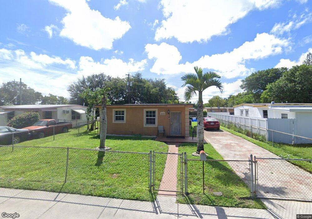
2030 Service Rd Opa Locka, FL 33054
Estimated Value: $309,000 - $376,000
2
Beds
1
Bath
999
Sq Ft
$352/Sq Ft
Est. Value
About This Home
This home is located at 2030 Service Rd, Opa Locka, FL 33054 and is currently estimated at $351,535, approximately $351 per square foot. 2030 Service Rd is a home located in Miami-Dade County with nearby schools including Nathan B. Young Elementary School, North Dade Middle School, and Hialeah-Miami Lakes Senior High School.
Ownership History
Date
Name
Owned For
Owner Type
Purchase Details
Closed on
Nov 12, 2018
Sold by
West Gloria A and Edwards Dorell Angelo
Bought by
Edwards Dorell Angelo and West Gloria A
Current Estimated Value
Purchase Details
Closed on
May 24, 2017
Sold by
West Gloria
Bought by
West Gloria A
Home Financials for this Owner
Home Financials are based on the most recent Mortgage that was taken out on this home.
Original Mortgage
$61,560
Interest Rate
4.08%
Mortgage Type
New Conventional
Purchase Details
Closed on
May 17, 2017
Sold by
West Arthur Lee
Bought by
West Gloria A
Home Financials for this Owner
Home Financials are based on the most recent Mortgage that was taken out on this home.
Original Mortgage
$61,560
Interest Rate
4.08%
Mortgage Type
New Conventional
Create a Home Valuation Report for This Property
The Home Valuation Report is an in-depth analysis detailing your home's value as well as a comparison with similar homes in the area
Home Values in the Area
Average Home Value in this Area
Purchase History
| Date | Buyer | Sale Price | Title Company |
|---|---|---|---|
| Edwards Dorell Angelo | -- | Attorney | |
| West Gloria A | $77,000 | None Available | |
| West Gloria A | -- | None Available |
Source: Public Records
Mortgage History
| Date | Status | Borrower | Loan Amount |
|---|---|---|---|
| Previous Owner | West Gloria A | $61,560 |
Source: Public Records
Tax History
| Year | Tax Paid | Tax Assessment Tax Assessment Total Assessment is a certain percentage of the fair market value that is determined by local assessors to be the total taxable value of land and additions on the property. | Land | Improvement |
|---|---|---|---|---|
| 2025 | $2,526 | $123,753 | -- | -- |
| 2024 | $2,311 | $120,266 | -- | -- |
| 2023 | $2,311 | $116,764 | $0 | $0 |
| 2022 | $2,297 | $113,364 | $0 | $0 |
| 2021 | $2,252 | $110,063 | $0 | $0 |
| 2020 | $2,156 | $108,544 | $0 | $0 |
| 2019 | $2,110 | $106,104 | $0 | $0 |
| 2018 | $2,005 | $104,126 | $45,582 | $58,544 |
| 2017 | $675 | $33,590 | $0 | $0 |
| 2016 | $800 | $32,900 | $0 | $0 |
| 2015 | $755 | $32,672 | $0 | $0 |
| 2014 | $716 | $32,413 | $0 | $0 |
Source: Public Records
Map
Nearby Homes
- 2001 Rutland St
- 1980 Service Rd
- 2061 Rutland St
- 2021 Wilmington St
- 1951 Rutland St
- 1950 Service Rd
- 1920 Rutland St
- 1897 Rutland St
- 2121 Rutland St
- 1940 Ali Baba Ave
- 1950 Ali Baba Ave
- 2111 York St
- 2061 Washington Ave Unit 4
- 2180 Rutland St
- 14585 NW 22nd Ave
- 2013 Washington Ave
- 15015 NW 22nd Ave
- 15140 NW 18th Ave
- 14240 NW 22nd Ave Unit 3
- 2155 NW 152nd St
Your Personal Tour Guide
Ask me questions while you tour the home.