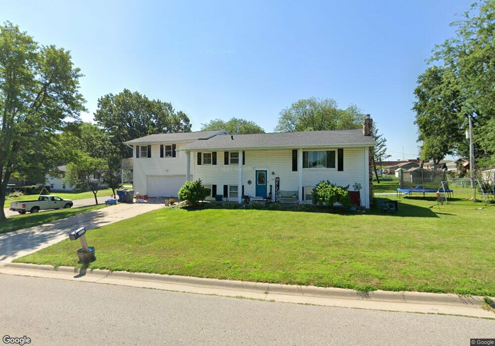
2031 Maynard Ave Waterloo, IA 50701
Estimated Value: $233,000 - $270,000
2
Beds
3
Baths
1,800
Sq Ft
$140/Sq Ft
Est. Value
About This Home
This home is located at 2031 Maynard Ave, Waterloo, IA 50701 and is currently estimated at $252,478, approximately $140 per square foot. 2031 Maynard Ave is a home located in Black Hawk County with nearby schools including Becker Elementary School, Central Middle School, and East High School.
Ownership History
Date
Name
Owned For
Owner Type
Purchase Details
Closed on
Apr 1, 2019
Sold by
Malcolm Darren J
Bought by
Malcolm Wendy N
Current Estimated Value
Purchase Details
Closed on
Dec 24, 2007
Sold by
Keller Blaze M
Bought by
Malcolm Darren J and Malcolm Wendy N
Home Financials for this Owner
Home Financials are based on the most recent Mortgage that was taken out on this home.
Original Mortgage
$125,000
Interest Rate
6.27%
Mortgage Type
New Conventional
Create a Home Valuation Report for This Property
The Home Valuation Report is an in-depth analysis detailing your home's value as well as a comparison with similar homes in the area
Purchase History
| Date | Buyer | Sale Price | Title Company |
|---|---|---|---|
| Malcolm Wendy N | -- | -- | |
| Malcolm Darren J | $137,000 | Title Services Corporation |
Source: Public Records
Mortgage History
| Date | Status | Borrower | Loan Amount |
|---|---|---|---|
| Previous Owner | Malcolm Darren J | $125,000 |
Source: Public Records
Tax History
| Year | Tax Paid | Tax Assessment Tax Assessment Total Assessment is a certain percentage of the fair market value that is determined by local assessors to be the total taxable value of land and additions on the property. | Land | Improvement |
|---|---|---|---|---|
| 2025 | $5,458 | $251,430 | $28,700 | $222,730 |
| 2024 | $5,458 | $251,620 | $28,700 | $222,920 |
| 2023 | $4,160 | $251,620 | $28,700 | $222,920 |
| 2022 | $4,050 | $189,380 | $28,700 | $160,680 |
| 2021 | $4,049 | $189,380 | $28,700 | $160,680 |
| 2020 | $4,122 | $184,970 | $24,290 | $160,680 |
| 2019 | $4,122 | $184,970 | $24,290 | $160,680 |
| 2018 | $3,944 | $176,930 | $24,290 | $152,640 |
| 2017 | $4,064 | $176,930 | $24,290 | $152,640 |
| 2016 | $4,014 | $176,930 | $24,290 | $152,640 |
| 2015 | $4,014 | $176,930 | $24,290 | $152,640 |
| 2014 | $4,090 | $176,930 | $24,290 | $152,640 |
Source: Public Records
Map
Nearby Homes
- 320 Valley Rd
- 412 Hughes Dr
- 1906 Coachman Dr
- 0 Bergen Dr
- 600 Beverly Hills St
- 425 Auburn St
- 211 Auburn St
- 301 S Hackett Rd
- 1434 Rainbow Dr
- 114 Hanna Blvd
- 2117 Tilbury Rd
- 2009 Wembley Rd
- 1712 Rainbow Dr
- 819 Hanna Blvd
- 1811 Sager Ave
- 456 Loma St
- 2.29 Acres Ansborough Ave
- 328 Drynan Dr
- 712 Upton Ave
- 108 Helen Rd
- 2030 Maynard Ave
- 420 Hughes Dr
- 411 Christensen Rd
- 2022 Maynard Ave
- 405 Christensen Rd
- 2009 Maynard Ave
- 419 Christensen Rd
- 411 Hughes Dr
- 2014 Maynard Ave
- 428 Hughes Dr
- 419 Hughes Dr
- 427 Christensen Rd
- 404 Christensen Rd
- 2047 Maxine Ave
- 2041 Maxine Ave
- 436 Hughes Dr
- 427 Hughes Dr
- 2031 Maxine Ave
- 435 Christensen Rd
- 410 Christensen Rd
Your Personal Tour Guide
Ask me questions while you tour the home.