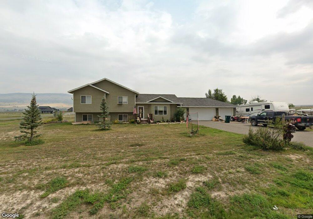
2034 Harvest Loop East Helena, MT 59635
Estimated Value: $563,053 - $639,000
3
Beds
2
Baths
1,505
Sq Ft
$395/Sq Ft
Est. Value
About This Home
This home is located at 2034 Harvest Loop, East Helena, MT 59635 and is currently estimated at $595,013, approximately $395 per square foot. 2034 Harvest Loop is a home located in Lewis and Clark County with nearby schools including Eastgate School, Radley Elementary School, and Prickly Pear Elementary School.
Ownership History
Date
Name
Owned For
Owner Type
Purchase Details
Closed on
Aug 7, 2006
Sold by
Baird Timothy J and Bauer Stacy Jo
Bought by
Baird Timothy J and Baird Stacy Jo
Current Estimated Value
Purchase Details
Closed on
Mar 27, 2006
Sold by
H & H Development Co Inc
Bought by
Baird Timothy J and Bauer Stacy Jo
Home Financials for this Owner
Home Financials are based on the most recent Mortgage that was taken out on this home.
Original Mortgage
$161,597
Outstanding Balance
$92,273
Interest Rate
6.25%
Mortgage Type
Construction
Estimated Equity
$502,740
Create a Home Valuation Report for This Property
The Home Valuation Report is an in-depth analysis detailing your home's value as well as a comparison with similar homes in the area
Home Values in the Area
Average Home Value in this Area
Purchase History
| Date | Buyer | Sale Price | Title Company |
|---|---|---|---|
| Baird Timothy J | -- | First Montana Title Company | |
| Baird Timothy J | -- | First Montana Title Company |
Source: Public Records
Mortgage History
| Date | Status | Borrower | Loan Amount |
|---|---|---|---|
| Open | Baird Timothy J | $161,597 |
Source: Public Records
Tax History Compared to Growth
Tax History
| Year | Tax Paid | Tax Assessment Tax Assessment Total Assessment is a certain percentage of the fair market value that is determined by local assessors to be the total taxable value of land and additions on the property. | Land | Improvement |
|---|---|---|---|---|
| 2025 | $2,367 | $543,300 | $0 | $0 |
| 2024 | $3,289 | $438,100 | $0 | $0 |
| 2023 | $3,803 | $438,100 | $0 | $0 |
| 2022 | $3,141 | $297,100 | $0 | $0 |
| 2021 | $2,913 | $297,100 | $0 | $0 |
| 2020 | $3,236 | $285,900 | $0 | $0 |
| 2019 | $3,363 | $285,900 | $0 | $0 |
| 2018 | $2,912 | $247,300 | $0 | $0 |
| 2017 | $2,051 | $247,300 | $0 | $0 |
| 2016 | $2,374 | $234,900 | $0 | $0 |
| 2015 | $1,979 | $234,900 | $0 | $0 |
| 2014 | $2,138 | $138,913 | $0 | $0 |
Source: Public Records
Map
Nearby Homes
- 1920 Martha Dr
- 2198 Crested Wheat Loop
- 2244 Dryland Loop
- 6008 Spokane Ranch Rd
- 5946 Johnson Rd
- TBD Jimmy Green Rd
- 24 Jimmy Green Rd
- 6000 Pine Meadow Rd
- 6045 Canyon Ferry Rd
- 6285 Elkhorn Rd
- 2910 Ranger Dr
- 6220 Elkhorn Rd
- 2315 Cattle Dr
- 2905 Ranger Dr
- 3017 Ranger Dr
- 5417 Peppergrass Rd
- 3108 Holmberg Dr
- 5472 Fireweed Loop
- 5468 Fireweed Loop
- 2640 Stagecoach Dr
- 2026 Harvest Loop
- 2027 Harvest Loop
- 1907 Harvest Loop
- 1906 Harvest Loop
- 2020 Harvest Loop
- 5825 Kamp Rd
- 1901 Spokane Creek Rd
- 1915 Harvest Loop
- 2014 Harvest Loop
- 2009 Harvest Loop
- 1912 Harvest Loop
- 1995 Harvest Loop
- 1987 Harvest Loop
- 2008 Harvest Loop
- 1996 Harvest Loop
- 2002 Harvest Loop
- 2002 Harvest Loop
- 5845 Kamp Rd
- 1990 Harvest Loop
- 1919 Harvest Loop