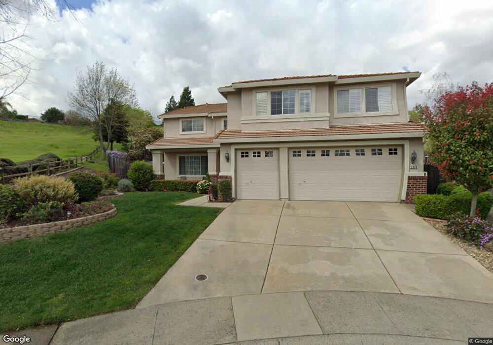
2036 Denton Ct Rocklin, CA 95765
Stanford Ranch NeighborhoodEstimated Value: $760,000 - $963,514
5
Beds
3
Baths
3,411
Sq Ft
$261/Sq Ft
Est. Value
About This Home
This home is located at 2036 Denton Ct, Rocklin, CA 95765 and is currently estimated at $891,879, approximately $261 per square foot. 2036 Denton Ct is a home located in Placer County with nearby schools including Breen Elementary, Granite Oaks Middle, and Rocklin High.
Ownership History
Date
Name
Owned For
Owner Type
Purchase Details
Closed on
Oct 7, 2013
Sold by
White Jonathan M and White Mary T
Bought by
White Jonathan M and White Mary T
Current Estimated Value
Purchase Details
Closed on
May 27, 1998
Sold by
Lewis Homes Enterprises
Bought by
White Jonathon M
Home Financials for this Owner
Home Financials are based on the most recent Mortgage that was taken out on this home.
Original Mortgage
$207,898
Interest Rate
7.13%
Create a Home Valuation Report for This Property
The Home Valuation Report is an in-depth analysis detailing your home's value as well as a comparison with similar homes in the area
Home Values in the Area
Average Home Value in this Area
Purchase History
| Date | Buyer | Sale Price | Title Company |
|---|---|---|---|
| White Jonathan M | -- | None Available | |
| White Jonathon M | $260,000 | Placer Title Company |
Source: Public Records
Mortgage History
| Date | Status | Borrower | Loan Amount |
|---|---|---|---|
| Previous Owner | White Jonathon M | $207,898 |
Source: Public Records
Tax History
| Year | Tax Paid | Tax Assessment Tax Assessment Total Assessment is a certain percentage of the fair market value that is determined by local assessors to be the total taxable value of land and additions on the property. | Land | Improvement |
|---|---|---|---|---|
| 2025 | $4,808 | $435,600 | $165,963 | $269,637 |
| 2023 | $4,808 | $418,686 | $159,519 | $259,167 |
| 2022 | $4,655 | $410,478 | $156,392 | $254,086 |
| 2021 | $4,604 | $402,430 | $153,326 | $249,104 |
| 2020 | $4,597 | $398,304 | $151,754 | $246,550 |
| 2019 | $5,535 | $390,495 | $148,779 | $241,716 |
| 2018 | $5,391 | $382,839 | $145,862 | $236,977 |
| 2017 | $5,366 | $375,333 | $143,002 | $232,331 |
| 2016 | $5,216 | $367,975 | $140,199 | $227,776 |
| 2015 | $5,137 | $362,449 | $138,094 | $224,355 |
| 2014 | $5,582 | $355,350 | $135,389 | $219,961 |
Source: Public Records
Map
Nearby Homes
- 2057 Archer Cir
- 2024 Archer Cir
- 1914 Harvest Ct
- 1816 Talon Rd
- 5329 Wesley Rd
- 1707 Poppy Dr
- 1701 Poppy Dr
- 2726 Genesee Dr
- 2408 Galloping Trail Ct
- 2518 Cowboy Ct
- 5309 Quane Ct
- 2712 Ashland Ct
- 1214 Regina St
- 3140 Golden Trail St
- 1115 Sedona St
- 3146 Golden Trail St
- 1112 Sedona St
- 5112 Stratton Ct
- 2501 Mossy Oak Ct
- 5116 Camden Rd
- 2032 Denton Ct
- 2028 Denton Ct
- 2024 Denton Ct
- 5406 Rock Field Ct
- 5408 Iron Point Ct
- 5404 Rock Field Ct
- 5535 New Vista Dr
- 5537 New Vista Dr
- 2016 Denton Ct
- 5601 New Vista Ct
- 5406 Iron Point Ct
- 5402 Rock Field Ct
- 5407 Iron Point Ct
- 2012 Denton Ct
- 5605 New Vista Ct
- 5404 Iron Point Ct
- 5405 Rock Field Ct
- 5400 Rock Field Ct
- 2008 Denton Ct
- 5310 Ridge Gate Ct
Your Personal Tour Guide
Ask me questions while you tour the home.