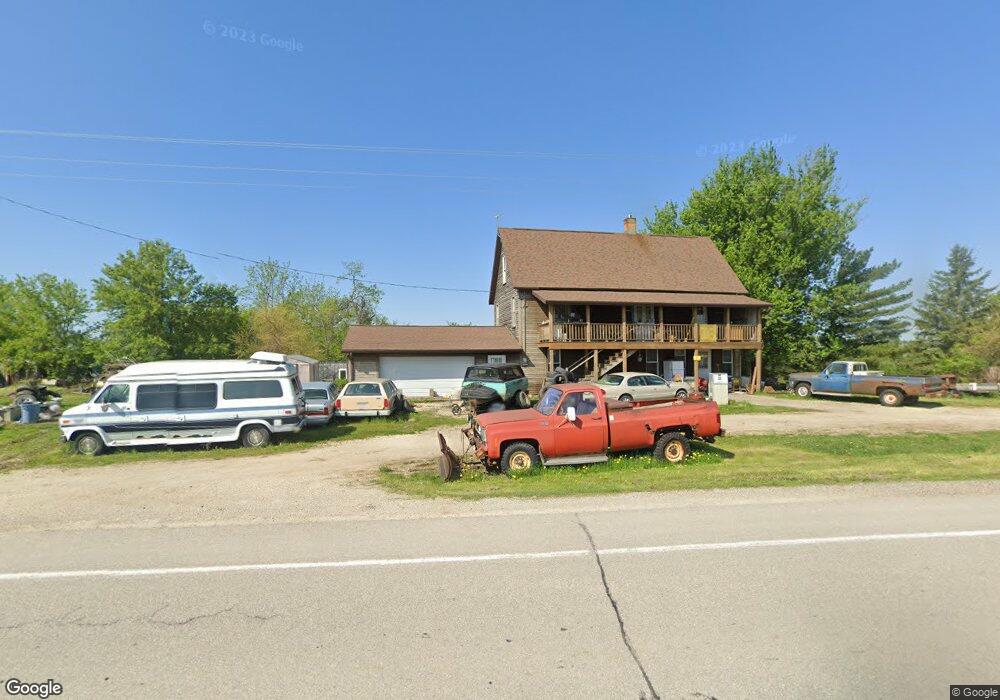
2036 Highway 76 N Waukon, IA 52172
Estimated Value: $199,000 - $229,000
4
Beds
1
Bath
1,536
Sq Ft
$142/Sq Ft
Est. Value
About This Home
This home is located at 2036 Highway 76 N, Waukon, IA 52172 and is currently estimated at $218,288, approximately $142 per square foot. 2036 Highway 76 N is a home located in Allamakee County with nearby schools including West Campus Elementary School, East Campus Elementary School, and Waukon Middle School.
Ownership History
Date
Name
Owned For
Owner Type
Purchase Details
Closed on
Mar 20, 2024
Sold by
J & J Deer Trails Llc
Bought by
Brink Darryl D and Brink Jean A
Current Estimated Value
Purchase Details
Closed on
Aug 23, 2023
Sold by
Quanrude Terry J
Bought by
J & J Deer Trails Llc
Home Financials for this Owner
Home Financials are based on the most recent Mortgage that was taken out on this home.
Original Mortgage
$130,000
Interest Rate
6.96%
Mortgage Type
New Conventional
Create a Home Valuation Report for This Property
The Home Valuation Report is an in-depth analysis detailing your home's value as well as a comparison with similar homes in the area
Home Values in the Area
Average Home Value in this Area
Purchase History
| Date | Buyer | Sale Price | Title Company |
|---|---|---|---|
| Brink Darryl D | -- | None Listed On Document | |
| J & J Deer Trails Llc | $115,000 | None Listed On Document |
Source: Public Records
Mortgage History
| Date | Status | Borrower | Loan Amount |
|---|---|---|---|
| Previous Owner | J & J Deer Trails Llc | $130,000 |
Source: Public Records
Tax History Compared to Growth
Tax History
| Year | Tax Paid | Tax Assessment Tax Assessment Total Assessment is a certain percentage of the fair market value that is determined by local assessors to be the total taxable value of land and additions on the property. | Land | Improvement |
|---|---|---|---|---|
| 2025 | $898 | $82,100 | $23,000 | $59,100 |
| 2024 | $898 | $77,800 | $23,000 | $54,800 |
| 2023 | $1,464 | $151,800 | $38,000 | $113,800 |
| 2022 | $1,112 | $105,300 | $28,600 | $76,700 |
| 2021 | $1,158 | $105,300 | $28,600 | $76,700 |
| 2020 | $1,158 | $102,600 | $25,800 | $76,800 |
| 2019 | $1,086 | $95,600 | $0 | $0 |
| 2018 | $1,048 | $95,600 | $0 | $0 |
| 2017 | $1,048 | $85,600 | $0 | $0 |
| 2016 | $922 | $85,600 | $0 | $0 |
| 2015 | $922 | $85,600 | $0 | $0 |
| 2014 | $848 | $79,800 | $0 | $0 |
Source: Public Records
Map
Nearby Homes
- 2036 Iowa 76
- 2181 Iowa 76
- TBD Bear Creek Dr
- 103 11th Ave NW
- 933 Iowa River Dr
- 820 4th St NW
- 821 4th St NW
- 430 9th St NW
- 602 2nd St NW
- 315 4th Ave NW
- 607 W Main St
- 20 3rd Ave NE
- 605 1st Ave SW
- 2972 River Rd
- 0 Parcel Id#1031376005 Unit 20211907
- 0 Parcel Id#1031351004 Unit 20211906
- 0 Parcel Id#1031376012 Unit 20211905
- 0 Parcel Id#1031376013 Unit 20211902
- 0 Parcel Id#1031351006 Unit 20211900
- 0 Parcel Id#1031351007 Unit 20211899
- 2049 Highway 76 N
- 2001 Highway 76 N
- 2011 Iverson Bridge Rd
- 0 Iverson Bridge Rd Unit 16126
- 2082 Highway 76 N
- 1971 Sandpiper Rd
- 1972 Highway 76 N
- 1961 Sandpiper Rd
- 2092 Highway 76 N
- 581 Hanover Dr
- 624 Pioneer Dr
- 531 Hanover Hill Ln
- 2105 Iowa 76
- 2106 Highway 76 N
- 1956 Sandpiper Rd
- 1956 Sandpiper Rd
- 534 Hanover Hill Ln
- 2056 Iverson Bridge Rd