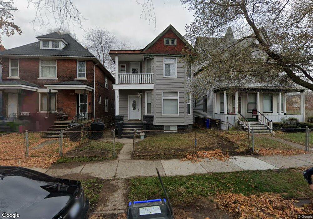
2037 Clarkdale St Detroit, MI 48209
Southwest Detroit NeighborhoodEstimated Value: $109,000 - $182,000
--
Bed
2
Baths
2,518
Sq Ft
$62/Sq Ft
Est. Value
About This Home
This home is located at 2037 Clarkdale St, Detroit, MI 48209 and is currently estimated at $156,051, approximately $61 per square foot. 2037 Clarkdale St is a home located in Wayne County with nearby schools including Maybury Elementary School, Charles L. Spain Elementary-Middle School, and Edward 'Duke' Ellington Conservatory of Music and Art.
Ownership History
Date
Name
Owned For
Owner Type
Purchase Details
Closed on
Jun 11, 2021
Sold by
Detroit Land Bank Authority
Bought by
Mulgado Kevin
Current Estimated Value
Purchase Details
Closed on
Dec 19, 2018
Sold by
City Of Detroit
Bought by
Detroit Land Bank Authority
Purchase Details
Closed on
Sep 1, 2017
Sold by
Sabree Eric R
Bought by
City Of Detroit Planning And Development
Purchase Details
Closed on
Oct 19, 2005
Sold by
Angiano Frances
Bought by
Reyes Mario
Create a Home Valuation Report for This Property
The Home Valuation Report is an in-depth analysis detailing your home's value as well as a comparison with similar homes in the area
Home Values in the Area
Average Home Value in this Area
Purchase History
| Date | Buyer | Sale Price | Title Company |
|---|---|---|---|
| Mulgado Kevin | $101,200 | Amrock Inc | |
| Detroit Land Bank Authority | -- | None Available | |
| City Of Detroit Planning And Development | $3,583 | None Available | |
| Reyes Mario | $13,500 | Multiple |
Source: Public Records
Tax History Compared to Growth
Tax History
| Year | Tax Paid | Tax Assessment Tax Assessment Total Assessment is a certain percentage of the fair market value that is determined by local assessors to be the total taxable value of land and additions on the property. | Land | Improvement |
|---|---|---|---|---|
| 2025 | $1,736 | $35,700 | $0 | $0 |
| 2024 | $1,736 | $29,300 | $0 | $0 |
| 2023 | $1,932 | $22,600 | $0 | $0 |
| 2022 | $2,062 | $19,700 | $0 | $0 |
| 2021 | $3,753 | $0 | $0 | $0 |
| 2020 | $0 | $0 | $0 | $0 |
| 2019 | $981 | $0 | $0 | $0 |
| 2018 | $340 | $0 | $0 | $0 |
| 2017 | $122 | $8,700 | $0 | $0 |
| 2016 | $851 | $14,400 | $0 | $0 |
| 2015 | $670 | $6,700 | $0 | $0 |
| 2013 | $740 | $7,398 | $0 | $0 |
| 2010 | -- | $10,600 | $405 | $10,195 |
Source: Public Records
Map
Nearby Homes
- 2012 Hubbard St
- 1965 Vinewood St
- 735 Hubbard St
- 1028 Lansing St
- 1401 Mc Kinstry St
- 1937 Morrell St
- 1620 Morrell St
- 1408 Lansing St
- 3644 Bagley St
- 5627 Brandon St
- 1547 25th St
- 3553 Bagley St
- 1454 24th St
- 3102 24th St
- 1206 Lansing St
- 346 W Grand Blvd
- 5839 Mcmillan St
- 5854 Romeyn St
- 1502 Campbell St
- 817 W Grand Blvd
- 2029 Clarkdale St
- 2045 Clarkdale St
- 2023 Clarkdale St
- 2017 Clarkdale St
- 2054 Clark St
- 2063 Clarkdale St
- 2056 Clark St
- 2048 Clark St
- 2054 Clarkdale St
- 2056 Clarkdale St
- 2042 Clark St
- 2009 Clarkdale St
- 2036 Clark St
- 2069 Clarkdale St
- 2042 Clarkdale St
- 2036 Clarkdale St
- 2048 Clarkdale St
- 2030 Clarkdale St
- 2030 Clark St
- 2058 Clark St