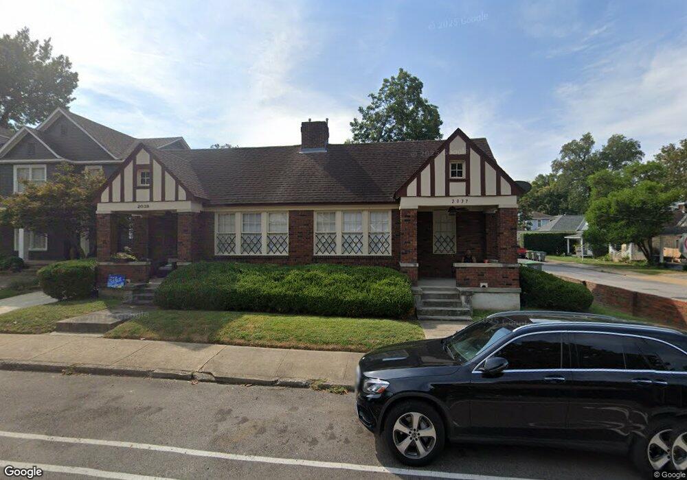
2037 Peabody Ave Memphis, TN 38104
Cooper-Young NeighborhoodEstimated Value: $272,799 - $371,000
4
Beds
4
Baths
2,620
Sq Ft
$124/Sq Ft
Est. Value
About This Home
This home is located at 2037 Peabody Ave, Memphis, TN 38104 and is currently estimated at $325,450, approximately $124 per square foot. 2037 Peabody Ave is a home located in Shelby County with nearby schools including Idlewild Elementary School, Central High School, and Compass Community School Midtown Campus.
Ownership History
Date
Name
Owned For
Owner Type
Purchase Details
Closed on
Nov 20, 1999
Sold by
Gongleski Frank J
Bought by
Sissman Ben G and Sissman Nancy J
Current Estimated Value
Home Financials for this Owner
Home Financials are based on the most recent Mortgage that was taken out on this home.
Original Mortgage
$107,100
Outstanding Balance
$33,047
Interest Rate
7.89%
Estimated Equity
$292,403
Create a Home Valuation Report for This Property
The Home Valuation Report is an in-depth analysis detailing your home's value as well as a comparison with similar homes in the area
Home Values in the Area
Average Home Value in this Area
Purchase History
| Date | Buyer | Sale Price | Title Company |
|---|---|---|---|
| Sissman Ben G | $119,000 | -- |
Source: Public Records
Mortgage History
| Date | Status | Borrower | Loan Amount |
|---|---|---|---|
| Open | Sissman Ben G | $107,100 |
Source: Public Records
Tax History Compared to Growth
Tax History
| Year | Tax Paid | Tax Assessment Tax Assessment Total Assessment is a certain percentage of the fair market value that is determined by local assessors to be the total taxable value of land and additions on the property. | Land | Improvement |
|---|---|---|---|---|
| 2025 | $3,234 | $125,040 | $35,360 | $89,680 |
| 2024 | $3,234 | $95,400 | $23,360 | $72,040 |
| 2023 | $5,811 | $95,400 | $23,360 | $72,040 |
| 2022 | $5,811 | $95,400 | $23,360 | $72,040 |
| 2021 | $5,880 | $95,400 | $23,360 | $72,040 |
| 2020 | $5,449 | $75,200 | $23,360 | $51,840 |
| 2019 | $5,449 | $75,200 | $23,360 | $51,840 |
| 2018 | $5,449 | $75,200 | $23,360 | $51,840 |
| 2017 | $3,091 | $75,200 | $23,360 | $51,840 |
| 2016 | $3,045 | $69,680 | $0 | $0 |
| 2014 | $3,045 | $69,680 | $0 | $0 |
Source: Public Records
Map
Nearby Homes
- 2060 Carr Ave
- 2065 Peabody Ave
- 2046 Courtland Place
- 1999 Peabody Ave
- 2080 Vinton Ave
- 2086 Harbert Ave
- 2092 Harbert Ave
- 2092 Linden Ave
- 2113 Vinton Ave
- 1971 Vinton Ave
- 2096 Linden Ave
- 1947 Linden Ave
- 519 Summitt St
- 521 Summitt St
- 2007 Cowden Ave
- 2012 Higbee Ave
- 2006 Higbee Ave
- 506 Peabody Square Unit 506
- 2100 Higbee Ave
- 31 S Morrison St
- 2041 Peabody Ave
- 2043 Peabody Ave
- 2040 Carr Ave
- 2038 Carr Ave
- 2042 Carr Ave
- 2047 Peabody Ave
- 2044 Carr Ave
- 523 Diana St
- 2046 Carr Ave
- 2053 Peabody Ave
- 2051 Peabody Ave
- 529 Diana St
- 2034 Peabody Ave
- 2042 Peabody Ave
- 2030 Peabody Ave
- 533 Diana St
- 2054 Carr Ave
- 2046 Peabody Ave
- 2061 Peabody Ave
- 2050 Peabody Ave