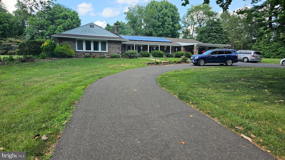
204 Dale Rd Mount Holly, NJ 08060
Estimated payment $3,976/month
Highlights
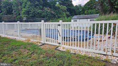
- Tennis Courts
- 1.5 Acre Lot
- Wood Flooring
- Rancocas Valley Regional High School Rated A-
- Post and Beam
- 2 Fireplaces
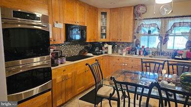
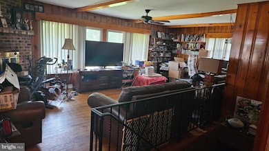
About This Home
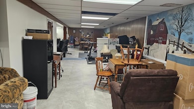
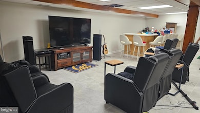
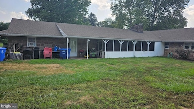
A fantastic opportunity to live in a spacious Ranch sitting on 1.5 acres with privacy. The home includes a pool and tennis courts with the addition of a finished basement. The basement offers access from garage and main level. This home awaits its next steward to add personal touch and TLC. Buyer responsible for township certifications.
Listing Agent
(609) 203-1144 wendy.merkovitz@foxroach.com BHHS Fox & Roach - Princeton License #9700116 Listed on: 08/05/2025

Home Details
Home Type
- Single Family
Est. Annual Taxes
- $11,393
Year Built
- Built in 1958
Parking
- 2 Car Attached Garage
- 4 Driveway Spaces
- Front Facing Garage
Home Design
- Post and Beam
- Rambler Architecture
- Slab Foundation
Interior Spaces
- 2,756 Sq Ft Home
- Property has 1 Level
- 2 Fireplaces
- Wood Flooring
Bedrooms and Bathrooms
- 4 Main Level Bedrooms
Finished Basement
- Connecting Stairway
- Garage Access
Utilities
- Central Air
- Heating System Uses Oil
- Well
- Electric Water Heater
- Septic Tank
Additional Features
- Doors swing in
- Heating system powered by passive solar
- Tennis Courts
- 1.5 Acre Lot
Community Details
- No Home Owners Association
- None Ava Ilable Subdivision
Listing and Financial Details
- Tax Lot 00002
- Assessor Parcel Number 37-00909-00002
Map
Home Values in the Area
Average Home Value in this Area
Tax History
| Year | Tax Paid | Tax Assessment Tax Assessment Total Assessment is a certain percentage of the fair market value that is determined by local assessors to be the total taxable value of land and additions on the property. | Land | Improvement |
|---|---|---|---|---|
| 2025 | $11,393 | $405,600 | $97,500 | $308,100 |
| 2024 | $10,963 | $405,600 | $97,500 | $308,100 |
| 2023 | $10,963 | $405,600 | $97,500 | $308,100 |
| 2022 | $10,416 | $405,600 | $97,500 | $308,100 |
| 2021 | $10,030 | $405,600 | $97,500 | $308,100 |
| 2020 | $9,990 | $405,600 | $97,500 | $308,100 |
| 2019 | $9,787 | $405,600 | $97,500 | $308,100 |
| 2018 | $9,661 | $405,600 | $97,500 | $308,100 |
| 2017 | $9,406 | $405,600 | $97,500 | $308,100 |
| 2016 | $9,231 | $405,600 | $97,500 | $308,100 |
| 2015 | $9,053 | $405,600 | $97,500 | $308,100 |
| 2014 | $8,822 | $405,600 | $97,500 | $308,100 |
Property History
| Date | Event | Price | List to Sale | Price per Sq Ft |
|---|---|---|---|---|
| 09/26/2025 09/26/25 | Price Changed | $574,900 | -4.0% | $209 / Sq Ft |
| 08/05/2025 08/05/25 | For Sale | $599,000 | -- | $217 / Sq Ft |
Purchase History
| Date | Type | Sale Price | Title Company |
|---|---|---|---|
| Interfamily Deed Transfer | -- | -- | |
| Deed | $240,000 | Independence Abstract & Titl |
Mortgage History
| Date | Status | Loan Amount | Loan Type |
|---|---|---|---|
| Open | $395,200 | Fannie Mae Freddie Mac | |
| Previous Owner | $229,000 | No Value Available |
Source: Bright MLS
MLS Number: NJBL2093742
APN: 37-00909-0000-00002
Disclaimer: Certain information contained herein is derived from information provided by parties other than Homes.com. All information provided is deemed reliable, but is not guaranteed to be accurate and should be independently verified.
![]() The data relating to real estate for sale on this website appears in part through the BRIGHT Internet Data Exchange program, a voluntary cooperative exchange of property listing data between licensed real estate brokerage firms, and is provided by BRIGHT through a licensing agreement.
The data relating to real estate for sale on this website appears in part through the BRIGHT Internet Data Exchange program, a voluntary cooperative exchange of property listing data between licensed real estate brokerage firms, and is provided by BRIGHT through a licensing agreement.
Listing information is from various brokers who participate in the Bright MLS IDX program and not all listings may be visible on the site.
The property information being provided on or through the website is for the personal, non-commercial use of consumers and such information may not be used for any purpose other than to identify prospective properties consumers may be interested in purchasing.
Some properties which appear for sale on the website may no longer be available because they are for instance, under contract, sold or are no longer being offered for sale.
Property information displayed is deemed reliable but is not guaranteed.
Copyright 2025 Bright MLS, Inc.
- 16 Dogwood Dr
- 7 Brentwood Dr
- 5 Roberts Dr
- 19 Pastern Terrace
- 39 Fernbrooke Dr
- 14 Shelburne St
- 44 Wesley Ln
- 9 Shelburne St
- 120 Gilbert Rd
- 22 Sawgrass Dr
- 208 Whisper Ct Unit 208
- 20 Greenbrier Dr
- 726 Smith Ln
- 13 Tarnsfield Rd
- 724 Woodlane Rd
- 4 Brighton Ct
- 745 Holly Ln
- 205 Starling Ln
- 118 Greenwich Dr
- 70 Tarnsfield Rd
- 3000 Emily Ln
- 16 Elliot Ln
- 39 Spyglass Ct
- 156 E Country Club Dr
- 309 Northgate Village
- 1a Bentley Rd
- 501 Bloomfield Dr
- 502 Bloomfield Dr
- 64 Regency Dr
- 1 Kirby Ct
- 2315 Rancocas Rd
- 3A Hunters Cir
- 36 Kanabe Dr
- 35 Stanton Rd
- 302 Barrington Ct
- 1423 Kenny Cove Unit L3
- 1501 -03 Mount Holly Rd Unit 3
- 7B Dresser Ave Unit 1
- 12 Ross Rd
- 100 First Montgomery Dr