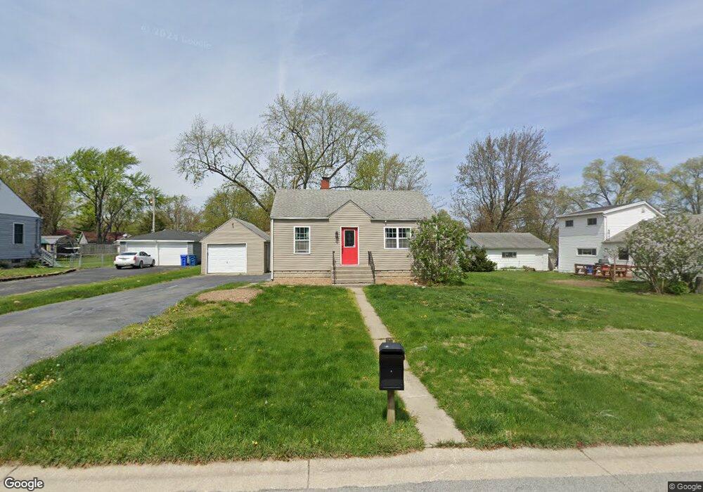
204 Maple St Crown Point, IN 46307
Estimated Value: $188,555 - $206,000
2
Beds
1
Bath
1,380
Sq Ft
$145/Sq Ft
Est. Value
About This Home
This home is located at 204 Maple St, Crown Point, IN 46307 and is currently estimated at $200,389, approximately $145 per square foot. 204 Maple St is a home located in Lake County with nearby schools including Timothy Ball Elementary School, Robert Taft Middle School, and Crown Point High School.
Ownership History
Date
Name
Owned For
Owner Type
Purchase Details
Closed on
Nov 21, 2016
Sold by
Wells Fargo Bank Na
Bought by
Hill Ricky Charles
Current Estimated Value
Purchase Details
Closed on
Sep 2, 2016
Sold by
Barnes Kenneth E
Bought by
Wells Fargo Bank Na
Purchase Details
Closed on
Nov 16, 2009
Sold by
Ivasiecko Venissa
Bought by
Barnes Kenneth E and Barnes Tina
Home Financials for this Owner
Home Financials are based on the most recent Mortgage that was taken out on this home.
Original Mortgage
$98,188
Interest Rate
4.9%
Mortgage Type
FHA
Purchase Details
Closed on
Sep 23, 2008
Sold by
Picard Edna I and Picard Edna L
Bought by
Ivasiecko Venissa
Home Financials for this Owner
Home Financials are based on the most recent Mortgage that was taken out on this home.
Original Mortgage
$25,000
Interest Rate
8%
Mortgage Type
Purchase Money Mortgage
Create a Home Valuation Report for This Property
The Home Valuation Report is an in-depth analysis detailing your home's value as well as a comparison with similar homes in the area
Home Values in the Area
Average Home Value in this Area
Purchase History
| Date | Buyer | Sale Price | Title Company |
|---|---|---|---|
| Hill Ricky Charles | -- | None Available | |
| Wells Fargo Bank Na | $82,650 | None Available | |
| Barnes Kenneth E | -- | Indiana Title Network Co | |
| Ivasiecko Venissa | -- | None Available |
Source: Public Records
Mortgage History
| Date | Status | Borrower | Loan Amount |
|---|---|---|---|
| Previous Owner | Barnes Kenneth E | $98,188 | |
| Previous Owner | Ivasiecko Venissa | $25,000 |
Source: Public Records
Tax History
| Year | Tax Paid | Tax Assessment Tax Assessment Total Assessment is a certain percentage of the fair market value that is determined by local assessors to be the total taxable value of land and additions on the property. | Land | Improvement |
|---|---|---|---|---|
| 2025 | $2,715 | $136,700 | $33,000 | $103,700 |
| 2024 | $3,326 | $127,600 | $33,000 | $94,600 |
| 2023 | $2,564 | $121,000 | $33,000 | $88,000 |
| 2022 | $2,564 | $116,000 | $33,000 | $83,000 |
| 2021 | $2,358 | $106,700 | $27,300 | $79,400 |
| 2020 | $2,334 | $105,600 | $27,300 | $78,300 |
| 2019 | $2,326 | $103,200 | $27,300 | $75,900 |
| 2018 | $2,565 | $98,900 | $27,300 | $71,600 |
| 2017 | $2,594 | $98,800 | $27,300 | $71,500 |
| 2016 | $181 | $96,000 | $27,300 | $68,700 |
| 2014 | $110 | $94,800 | $27,300 | $67,500 |
| 2013 | $5 | $88,100 | $27,300 | $60,800 |
Source: Public Records
Map
Nearby Homes
- 316 Oak Cir
- 324 Maple St
- 825 N Sherman St
- 1436 Bohling Place
- 350 Cochran Dr
- 1465 Mybeck Place
- 771 Kenmare Pkwy
- 306 Holton Ridge
- 301 Hoffman St
- 11241 Oak Ridge Ct
- 11200 Oak Ridge Ct
- 740 Meadow Ln
- 1362 Lehman Dr
- 1845 W 99th Place
- 600 W North St
- 900 Easy St
- 947 Oak Dr
- 516 E North St
- 619 W North St
- 1346 Parke Dr
Your Personal Tour Guide
Ask me questions while you tour the home.