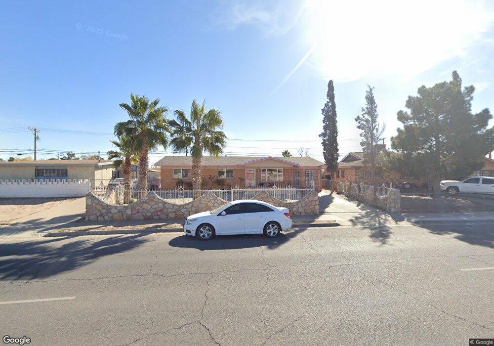
204 Mccarthy Ave El Paso, TX 79915
Thomas Manor NeighborhoodEstimated Value: $149,000 - $180,000
--
Bed
2
Baths
1,295
Sq Ft
$128/Sq Ft
Est. Value
About This Home
This home is located at 204 Mccarthy Ave, El Paso, TX 79915 and is currently estimated at $166,198, approximately $128 per square foot. 204 Mccarthy Ave is a home located in El Paso County with nearby schools including Thomas Manor, Riverside Middle School, and Riverside High School.
Ownership History
Date
Name
Owned For
Owner Type
Purchase Details
Closed on
Oct 28, 2019
Sold by
Jr Jose H and Ooran Yalima
Bought by
Grejeda Jose H and Grejeda Hermenjillda
Current Estimated Value
Purchase Details
Closed on
Feb 10, 2017
Sold by
Duran Yolima
Bought by
Durson Yolima and Grajeda Jose H
Purchase Details
Closed on
Dec 29, 2016
Sold by
Duran Yolima
Bought by
Duran Yolima and Grajeda Jose H
Purchase Details
Closed on
May 11, 2015
Sold by
Grajeda Jose H and Grajeda Hermenejilda
Bought by
Duran Yolima
Create a Home Valuation Report for This Property
The Home Valuation Report is an in-depth analysis detailing your home's value as well as a comparison with similar homes in the area
Home Values in the Area
Average Home Value in this Area
Purchase History
| Date | Buyer | Sale Price | Title Company |
|---|---|---|---|
| Grejeda Jose H | -- | None Available | |
| Durson Yolima | -- | None Available | |
| Duran Yolima | -- | None Available | |
| Duran Yolima | -- | None Available |
Source: Public Records
Tax History Compared to Growth
Tax History
| Year | Tax Paid | Tax Assessment Tax Assessment Total Assessment is a certain percentage of the fair market value that is determined by local assessors to be the total taxable value of land and additions on the property. | Land | Improvement |
|---|---|---|---|---|
| 2025 | $1,243 | $125,060 | -- | -- |
| 2024 | $1,243 | $113,691 | -- | -- |
| 2023 | $1,169 | $103,355 | $0 | $0 |
| 2022 | $2,918 | $93,959 | $0 | $0 |
| 2021 | $2,776 | $98,187 | $13,592 | $84,595 |
| 2020 | $2,453 | $77,652 | $13,592 | $64,060 |
| 2018 | $2,359 | $75,874 | $13,592 | $62,282 |
| 2017 | $2,356 | $77,062 | $13,592 | $63,470 |
| 2016 | $2,356 | $77,062 | $13,592 | $63,470 |
| 2015 | $1,012 | $77,062 | $13,592 | $63,470 |
| 2014 | $1,012 | $77,920 | $13,592 | $64,328 |
Source: Public Records
Map
Nearby Homes
- 205 Kelvin Ave
- 223 Kelvin Ave
- 222 Kelvin Ave
- 7807 Porche St
- 310 Kelvin Ave
- 7798 Rosedale St
- 7860 Porche St
- 7874 Broadway Dr
- 104 Chip Way
- 7632 Franklin Dr Unit 1-2
- 7907 Alameda Ave
- 7920 Porche St
- 7925 Broadway Dr
- 443 Cadwallader Dr
- 7952 Broadway Dr
- 423 N Carolina Dr
- 8041 Broadway Dr
- 7909 La Jolla Dr
- 7556 N Loop Dr
- 537 Emerson St
- 208 Mccarthy Ave
- 200 Mccarthy Ave
- 205 Jensen Ave
- 209 Jensen Ave
- 212 Mccarthy Ave
- 201 Jensen Ave
- 213 Jensen Ave
- 201 Mccarthy Ave
- 216 Mccarthy Ave
- 205 Mccarthy Ave
- 7701 Broadway Dr
- 217 Jensen Ave
- 7705 Broadway Dr
- 7705 Broadway Dr Unit 1
- 220 Mccarthy Ave
- 212 Gladys Ave
- 209 Mccarthy Ave
- 201 Gladys Ave
- 221 Jensen Ave
- 204 Jensen Ave Unit JEFF