Estimated Value: $252,803 - $358,000
6
Beds
4
Baths
2,000
Sq Ft
$153/Sq Ft
Est. Value
About This Home
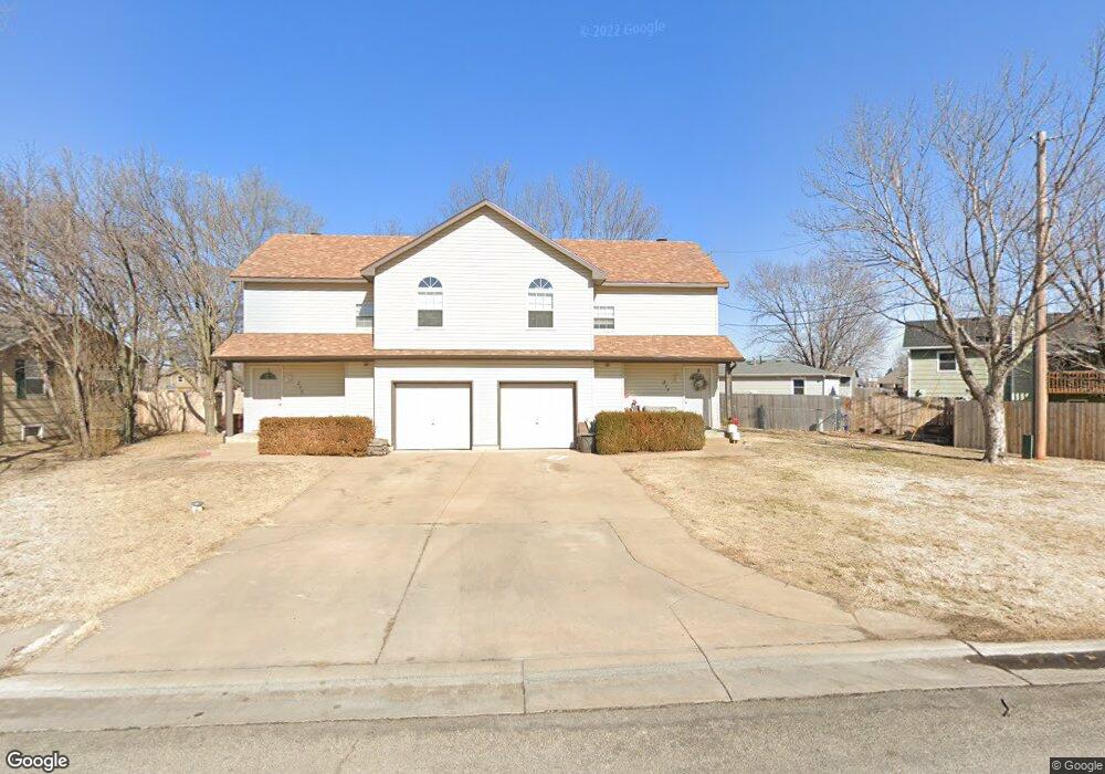
This home is located at 204 N Queen St, Maize, KS 67101 and is currently estimated at $305,402, approximately $152 per square foot. 204 N Queen St is a home located in Sedgwick County with nearby schools including Vermillion Elementary School, Pray-Woodman Elementary, and Maize Elementary School.
Ownership History
Date
Name
Owned For
Owner Type
Purchase Details
Closed on
Dec 20, 2023
Sold by
Stoneking Keith Allan and Joy Louanne
Bought by
Freedom Migdal Llc
Current Estimated Value
Home Financials for this Owner
Home Financials are based on the most recent Mortgage that was taken out on this home.
Original Mortgage
$85,000
Outstanding Balance
$83,517
Interest Rate
7.5%
Mortgage Type
Construction
Estimated Equity
$221,885
Create a Home Valuation Report for This Property
The Home Valuation Report is an in-depth analysis detailing your home's value as well as a comparison with similar homes in the area
Home Values in the Area
Average Home Value in this Area
Purchase History
| Date | Buyer | Sale Price | Title Company |
|---|---|---|---|
| Freedom Migdal Llc | -- | Kansas Secured Title |
Source: Public Records
Mortgage History
| Date | Status | Borrower | Loan Amount |
|---|---|---|---|
| Open | Freedom Migdal Llc | $85,000 |
Source: Public Records
Tax History Compared to Growth
Tax History
| Year | Tax Paid | Tax Assessment Tax Assessment Total Assessment is a certain percentage of the fair market value that is determined by local assessors to be the total taxable value of land and additions on the property. | Land | Improvement |
|---|---|---|---|---|
| 2025 | $3,385 | $25,243 | $5,095 | $20,148 |
| 2023 | $3,385 | $23,161 | $2,323 | $20,838 |
| 2022 | $3,024 | $20,011 | $2,197 | $17,814 |
| 2021 | $2,906 | $19,056 | $2,197 | $16,859 |
| 2020 | $2,710 | $17,814 | $2,197 | $15,617 |
| 2019 | $2,625 | $17,297 | $2,197 | $15,100 |
| 2018 | $2,482 | $16,319 | $1,587 | $14,732 |
| 2017 | $2,495 | $0 | $0 | $0 |
| 2016 | $2,394 | $0 | $0 | $0 |
| 2015 | -- | $0 | $0 | $0 |
| 2014 | -- | $0 | $0 | $0 |
Source: Public Records
Map
Nearby Homes
- 113 N Queen St
- 10730 W 53rd St N
- 319 Jonathan St
- 300 W Albert St Unit 29R
- 300 W Albert St Unit 9
- 300 W Albert St Unit 13
- 5463 Brisk Bay Ct
- 5465 Brisk Bay Ct
- 5561 Wandering Way
- 5591 Wandering Way
- 5468 N Briskbay Ct
- 403 S Sweetwater Rd
- 5603 Wandering Way
- 5563 Wandering Way
- 5558 Wandering Way
- 530 Conestoga Rd
- 429 S Longbranch Dr
- 5479 Brisk Bay St
- 5416 N Briskbay Ct
- 5414 N Briskbay Ct
- 208 N Queen St
- 205 N Heather Ln
- 209 N Heather Ln
- 305 N Heather Ln
- 209 N Queen St
- 212 N Queen St
- 213 N Queen St
- 109 N Queen St
- 309 N Heather Ln
- 313 Harvest Ln
- 208 N Heather Ln
- 309 Harvest Ln
- 204 N Heather Ln
- 105 N Queen St
- 216 N Queen St
- 317 N Heather Ln
- 315 N Heather Ln
- 112 N Heather Ln
- 101 N Heather Ln
- 404 N Hickory Ln