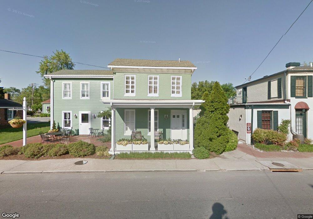
204 N Talbot St Saint Michaels, MD 21663
Estimated Value: $1,126,159
--
Bed
--
Bath
4,276
Sq Ft
$263/Sq Ft
Est. Value
About This Home
This home is located at 204 N Talbot St, Saint Michaels, MD 21663 and is currently priced at $1,126,159, approximately $263 per square foot. 204 N Talbot St is a home located in Talbot County with nearby schools including St. Michaels Elementary School, St. Michaels Middle/High School, and Easton High School.
Ownership History
Date
Name
Owned For
Owner Type
Purchase Details
Closed on
Dec 3, 2004
Sold by
Barrett James W
Bought by
202 Talbot Lc
Current Estimated Value
Purchase Details
Closed on
Feb 4, 2003
Sold by
Barrett James W
Bought by
Barrett James W
Purchase Details
Closed on
Oct 5, 1993
Sold by
Flagship Group
Bought by
Barrett James W
Home Financials for this Owner
Home Financials are based on the most recent Mortgage that was taken out on this home.
Original Mortgage
$180,000
Interest Rate
6.89%
Create a Home Valuation Report for This Property
The Home Valuation Report is an in-depth analysis detailing your home's value as well as a comparison with similar homes in the area
Home Values in the Area
Average Home Value in this Area
Purchase History
| Date | Buyer | Sale Price | Title Company |
|---|---|---|---|
| 202 Talbot Lc | $650,000 | -- | |
| Barrett James W | -- | -- | |
| Barrett James W | $232,500 | -- |
Source: Public Records
Mortgage History
| Date | Status | Borrower | Loan Amount |
|---|---|---|---|
| Previous Owner | Barrett James W | $180,000 |
Source: Public Records
Tax History Compared to Growth
Tax History
| Year | Tax Paid | Tax Assessment Tax Assessment Total Assessment is a certain percentage of the fair market value that is determined by local assessors to be the total taxable value of land and additions on the property. | Land | Improvement |
|---|---|---|---|---|
| 2025 | $15,272 | $1,459,200 | $713,500 | $745,700 |
| 2024 | $15,272 | $1,236,967 | $0 | $0 |
| 2023 | $12,051 | $1,014,733 | $0 | $0 |
| 2022 | $9,086 | $792,500 | $713,500 | $79,000 |
| 2021 | $17,773 | $792,500 | $713,500 | $79,000 |
| 2020 | $9,002 | $792,500 | $713,500 | $79,000 |
| 2019 | $4,032 | $935,900 | $713,500 | $222,400 |
| 2018 | $11,565 | $935,900 | $713,500 | $222,400 |
| 2017 | $10,910 | $935,900 | $0 | $0 |
| 2016 | $10,583 | $1,099,600 | $0 | $0 |
| 2015 | $11,570 | $1,099,600 | $0 | $0 |
| 2014 | $11,570 | $1,099,600 | $0 | $0 |
Source: Public Records
Map
Nearby Homes
- 408 Spinnaker Ln
- 207 Dodson Ave
- 209 Webb Ln
- 300 Perry St
- 102 Gloria Ave
- 216 Brooks Ln
- 100 Grace St
- 25500 Chance Farm Rd
- 107 E Chestnut St
- 0 Grace St Unit MDTA2012346
- 222 E Chestnut St
- 216 E Chew Ave
- 704 Meadow St
- Lot 16A Meadow St
- 105 Seymour Ave
- 807 Radcliff Ave
- 912 Calvert Ave
- 9171 Deepwater Point Rd
- 228 Tyler Ave
- 24362 Widgeon Place Unit 4
- 100 North St
- 116 N Talbot St
- 210 N Talbot St Unit 2ND FOOR
- 210 N Talbot St
- 103 Freemont St
- 112 N Talbot St
- 103 Freemont St Unit 1ST FLOOR
- 103 Freemont St
- 110 N Talbot St
- 102 Freemont St
- 211 N Talbot St
- 101 Fremont St
- 200 Dodson Ave
- 108 N Talbot St
- 101 Freemont St
- 0 Talbot St N Unit MDTA138216
- 203 N Talbot St
- 202 Dodson Ave
- 100 Freemont St
- 202 North St