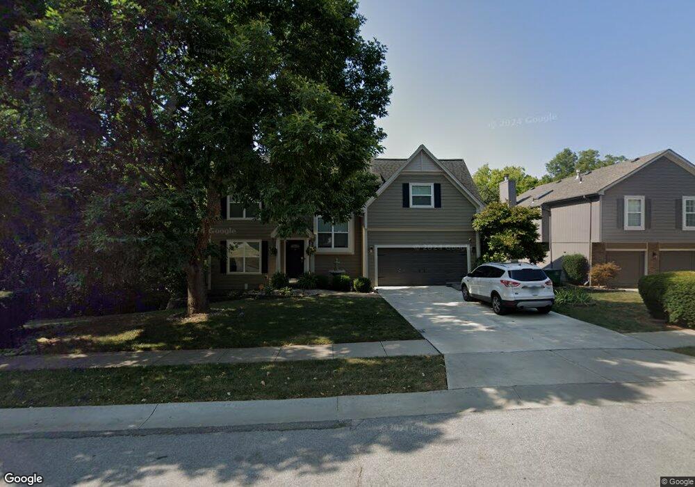
204 NW Whitlock Dr Lees Summit, MO 64081
Estimated Value: $367,000 - $460,000
4
Beds
4
Baths
2,554
Sq Ft
$158/Sq Ft
Est. Value
About This Home
This home is located at 204 NW Whitlock Dr, Lees Summit, MO 64081 and is currently estimated at $402,283, approximately $157 per square foot. 204 NW Whitlock Dr is a home located in Jackson County with nearby schools including Cedar Creek Elementary School, Pleasant Lea Middle School, and Lee's Summit Senior High School.
Ownership History
Date
Name
Owned For
Owner Type
Purchase Details
Closed on
Nov 6, 1996
Sold by
Hayob Ken
Bought by
Bitting Daniel W and Bitting Julie A
Current Estimated Value
Home Financials for this Owner
Home Financials are based on the most recent Mortgage that was taken out on this home.
Original Mortgage
$117,850
Outstanding Balance
$11,287
Interest Rate
7.77%
Mortgage Type
Purchase Money Mortgage
Estimated Equity
$390,996
Purchase Details
Closed on
Aug 24, 1995
Sold by
Summit Builders Inc
Bought by
Hayob Ken
Home Financials for this Owner
Home Financials are based on the most recent Mortgage that was taken out on this home.
Original Mortgage
$11,925
Interest Rate
7.39%
Mortgage Type
Purchase Money Mortgage
Create a Home Valuation Report for This Property
The Home Valuation Report is an in-depth analysis detailing your home's value as well as a comparison with similar homes in the area
Home Values in the Area
Average Home Value in this Area
Purchase History
| Date | Buyer | Sale Price | Title Company |
|---|---|---|---|
| Bitting Daniel W | -- | Chicago Title Insurance Co | |
| Hayob Ken | -- | -- |
Source: Public Records
Mortgage History
| Date | Status | Borrower | Loan Amount |
|---|---|---|---|
| Open | Bitting Daniel W | $117,850 | |
| Previous Owner | Hayob Ken | $11,925 |
Source: Public Records
Tax History Compared to Growth
Tax History
| Year | Tax Paid | Tax Assessment Tax Assessment Total Assessment is a certain percentage of the fair market value that is determined by local assessors to be the total taxable value of land and additions on the property. | Land | Improvement |
|---|---|---|---|---|
| 2025 | $4,675 | $62,064 | $8,480 | $53,584 |
| 2024 | $4,641 | $64,743 | $7,490 | $57,253 |
| 2023 | $4,641 | $64,743 | $7,357 | $57,386 |
| 2022 | $3,788 | $46,930 | $6,033 | $40,897 |
| 2021 | $3,867 | $46,930 | $6,033 | $40,897 |
| 2020 | $3,910 | $46,995 | $6,033 | $40,962 |
| 2019 | $3,803 | $46,995 | $6,033 | $40,962 |
| 2018 | $3,547 | $40,665 | $4,596 | $36,069 |
| 2017 | $3,547 | $40,665 | $4,596 | $36,069 |
| 2016 | $3,375 | $38,304 | $4,180 | $34,124 |
| 2014 | $3,413 | $37,972 | $3,918 | $34,054 |
Source: Public Records
Map
Nearby Homes
- 2237 NW Killarney Ln
- 2214 NW Killarney Ln
- 248 SW Winterpark Cir
- 19 SW Whitlock Dr
- 2123 NW Killarney Ln
- 361 NW Patch Ct
- 2090 NW O'Brien Rd
- 2108 NW Shamrock Ave
- 2086 NW O'Brien Rd
- Mariner Plan at Reserve at Woodside Ridge
- Trinity Plan at Reserve at Woodside Ridge
- Regency Plan at Reserve at Woodside Ridge
- Destiny Plan at Reserve at Woodside Ridge
- Bennington Plan at Reserve at Woodside Ridge
- Bentley Plan at Reserve at Woodside Ridge
- Oakleigh Plan at Reserve at Woodside Ridge
- Forrester 2824 Plan at Reserve at Woodside Ridge
- Destination 3300 Plan at Reserve at Woodside Ridge
- Forrester II Plan at Reserve at Woodside Ridge
- Modern Gunnison Plan at Reserve at Woodside Ridge - Woodside Ridge
- 208 NW Whitlock Dr
- 152 NW Whitlock Dr
- 212 NW Whitlock Dr
- 104 NW Cody Dr
- 148 NW Whitlock Dr
- 217 NW Whitlock Dr
- 101 NW Cody Dr
- 112 NW Cody Dr
- 216 NW Whitlock Dr
- 105 NW Cody Dr
- 144 NW Whitlock Dr
- 220 NW Whitlock Dr
- 116 NW Cody Dr
- 137 NW Whitlock Dr
- 113 NW Cody Dr
- 120 NW Cody Dr
- 225 NW Whitlock Dr
- 140 NW Whitlock Dr
- 136 NW Whitlock Dr
- 2351 NW Killarney Ln