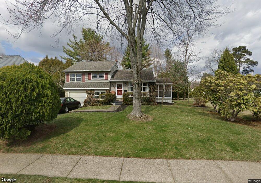
204 Parry Rd Warminster, PA 18974
Estimated Value: $412,000 - $428,000
3
Beds
2
Baths
1,092
Sq Ft
$388/Sq Ft
Est. Value
About This Home
This home is located at 204 Parry Rd, Warminster, PA 18974 and is currently estimated at $423,222, approximately $387 per square foot. 204 Parry Rd is a home located in Bucks County with nearby schools including Willow Dale El School, Log College Middle School, and William Tennent High School.
Ownership History
Date
Name
Owned For
Owner Type
Purchase Details
Closed on
Sep 22, 2006
Sold by
Mccomas Margaret and Mccomas Johnson Margaret
Bought by
Johnson Scott A and Mccomas Johnson Margaret
Current Estimated Value
Home Financials for this Owner
Home Financials are based on the most recent Mortgage that was taken out on this home.
Original Mortgage
$120,000
Interest Rate
6.47%
Mortgage Type
New Conventional
Purchase Details
Closed on
Sep 16, 2004
Sold by
Salamanca Salvatore and Mccomas Margaret
Bought by
Mccomas Margaret
Home Financials for this Owner
Home Financials are based on the most recent Mortgage that was taken out on this home.
Original Mortgage
$120,000
Interest Rate
6.37%
Mortgage Type
New Conventional
Create a Home Valuation Report for This Property
The Home Valuation Report is an in-depth analysis detailing your home's value as well as a comparison with similar homes in the area
Home Values in the Area
Average Home Value in this Area
Purchase History
| Date | Buyer | Sale Price | Title Company |
|---|---|---|---|
| Johnson Scott A | -- | None Available | |
| Mccomas Margaret | -- | -- |
Source: Public Records
Mortgage History
| Date | Status | Borrower | Loan Amount |
|---|---|---|---|
| Closed | Johnson Scott A | $120,000 | |
| Closed | Mccomas Margaret | $120,000 |
Source: Public Records
Tax History Compared to Growth
Tax History
| Year | Tax Paid | Tax Assessment Tax Assessment Total Assessment is a certain percentage of the fair market value that is determined by local assessors to be the total taxable value of land and additions on the property. | Land | Improvement |
|---|---|---|---|---|
| 2025 | $4,559 | $21,600 | $5,320 | $16,280 |
| 2024 | $4,559 | $21,600 | $5,320 | $16,280 |
| 2023 | $4,419 | $21,600 | $5,320 | $16,280 |
| 2022 | $4,324 | $21,600 | $5,320 | $16,280 |
| 2021 | $4,223 | $21,600 | $5,320 | $16,280 |
| 2020 | $4,164 | $21,600 | $5,320 | $16,280 |
| 2019 | $3,943 | $21,600 | $5,320 | $16,280 |
| 2018 | $3,849 | $21,600 | $5,320 | $16,280 |
| 2017 | $3,736 | $21,600 | $5,320 | $16,280 |
| 2016 | $3,736 | $21,600 | $5,320 | $16,280 |
| 2015 | $3,694 | $21,600 | $5,320 | $16,280 |
| 2014 | $3,694 | $21,600 | $5,320 | $16,280 |
Source: Public Records
Map
Nearby Homes
- 1130 Victoria Rd
- 1002 Windsor Rd
- 990 Meadow Glen Rd
- 1277 Beverly Rd
- 159 Villa Dr Unit 91
- 1274 Beverly Rd
- 100 Villa Dr Unit 224
- 64 Villa Dr Unit 206
- 416 Aspen Ln
- 1309 Clyde Rd
- 735 Claire Rd
- L:26 Street Rd
- 1334 Mallard Cir
- 724 Cypress Rd
- Faraday Plan at Liberty Ridge
- Westmont Plan at Liberty Ridge
- Northbrook Plan at Liberty Ridge
- 603 Liberty Ridge Rd
- 605 Liberty Ridge Rd
- 604 Liberty Ridge Rd
- 212 Parry Rd
- 196 Parry Rd
- 203 Norristown Rd
- 216 Parry Rd
- 195 Norristown Rd
- 186 Parry Rd
- 1055 Riviera Rd
- 1056 Dogwood Rd
- 211 Norristown Rd
- 217 Norristown Rd
- 185 Norristown Rd
- 178 Parry Rd
- 220 Parry Rd
- 1045 Riviera Rd
- 1054 Riviera Rd
- 221 Norristown Rd
- 177 Norristown Rd
- 1046 Dogwood Rd
- 1055 Dogwood Rd
- 1037 Riviera Rd