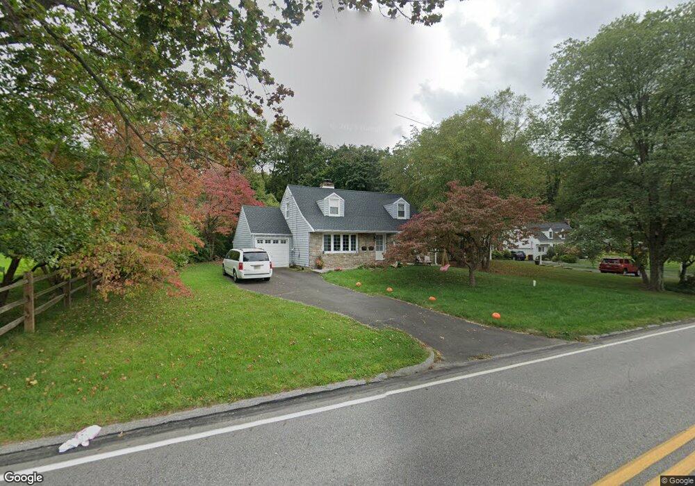
204 Station Ave Glenside, PA 19038
Estimated Value: $409,000 - $537,000
3
Beds
2
Baths
1,744
Sq Ft
$288/Sq Ft
Est. Value
About This Home
This home is located at 204 Station Ave, Glenside, PA 19038 and is currently estimated at $501,441, approximately $287 per square foot. 204 Station Ave is a home located in Montgomery County with nearby schools including Enfield Elementary School, Erdenheim Elementary School, and Springfield Township Middle School.
Ownership History
Date
Name
Owned For
Owner Type
Purchase Details
Closed on
Aug 14, 2020
Sold by
Katherine S Rice Estate
Bought by
Wasson Ryan D and Modricker Faith
Current Estimated Value
Home Financials for this Owner
Home Financials are based on the most recent Mortgage that was taken out on this home.
Original Mortgage
$150,000
Outstanding Balance
$132,812
Interest Rate
2.9%
Mortgage Type
New Conventional
Estimated Equity
$368,629
Purchase Details
Closed on
Apr 29, 1993
Bought by
Rice Katherine S
Create a Home Valuation Report for This Property
The Home Valuation Report is an in-depth analysis detailing your home's value as well as a comparison with similar homes in the area
Home Values in the Area
Average Home Value in this Area
Purchase History
| Date | Buyer | Sale Price | Title Company |
|---|---|---|---|
| Wasson Ryan D | $270,000 | None Available | |
| Rice Katherine S | $154,000 | -- |
Source: Public Records
Mortgage History
| Date | Status | Borrower | Loan Amount |
|---|---|---|---|
| Open | Wasson Ryan D | $150,000 |
Source: Public Records
Tax History Compared to Growth
Tax History
| Year | Tax Paid | Tax Assessment Tax Assessment Total Assessment is a certain percentage of the fair market value that is determined by local assessors to be the total taxable value of land and additions on the property. | Land | Improvement |
|---|---|---|---|---|
| 2025 | $7,853 | $166,720 | $53,490 | $113,230 |
| 2024 | $7,853 | $166,720 | $53,490 | $113,230 |
| 2023 | $7,579 | $166,720 | $53,490 | $113,230 |
| 2022 | $7,362 | $166,720 | $53,490 | $113,230 |
| 2021 | $7,170 | $166,720 | $53,490 | $113,230 |
| 2020 | $7,002 | $166,720 | $53,490 | $113,230 |
| 2019 | $6,895 | $166,720 | $53,490 | $113,230 |
| 2018 | $6,895 | $166,720 | $53,490 | $113,230 |
| 2017 | $6,582 | $166,720 | $53,490 | $113,230 |
| 2016 | $6,517 | $166,720 | $53,490 | $113,230 |
| 2015 | $6,195 | $166,720 | $53,490 | $113,230 |
| 2014 | $6,195 | $166,720 | $53,490 | $113,230 |
Source: Public Records
Map
Nearby Homes
- 56 Chelfield Rd
- 0 Logan Ave Unit PAMC2112680
- 120 Linden Ave
- 140 Linden Ave
- 222 Ruscombe Ave
- 162 Logan Ave
- 65 Limekiln Pike
- 245 Linden Ave
- 122 Garden Rd
- 0 Girard Ave
- 116 Twining Rd
- 118 Twining Rd
- 220 Garth Rd
- 314 Girard Ave
- 711 Custis Rd
- 332 Logan Ave
- 229 Edge Hill Rd
- 101 Orlando Ave
- 516 Beaver Rd
- 200 Redford Rd