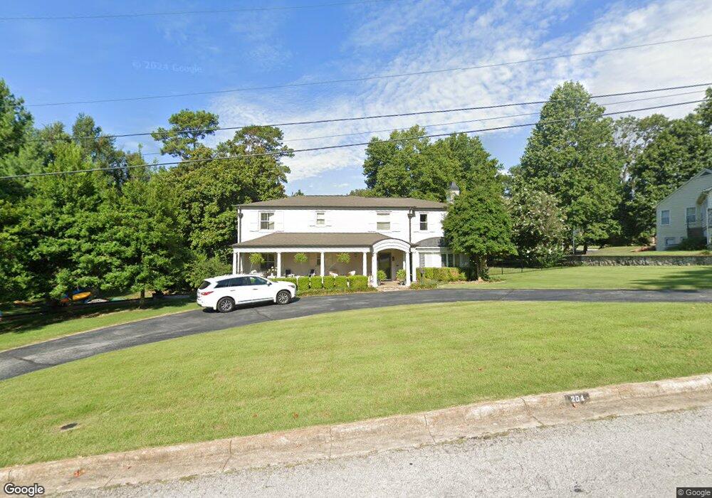
204 Tamarind St Harrison, AR 72601
Estimated Value: $356,000 - $421,242
3
Beds
4
Baths
4,671
Sq Ft
$86/Sq Ft
Est. Value
About This Home
This home is located at 204 Tamarind St, Harrison, AR 72601 and is currently estimated at $400,561, approximately $85 per square foot. 204 Tamarind St is a home located in Boone County with nearby schools including Forest Heights Elementary School, Harrison Jr. High School, and Harrison High School.
Ownership History
Date
Name
Owned For
Owner Type
Purchase Details
Closed on
Nov 16, 2005
Sold by
Conner Donnie W and Conner Betty
Bought by
Ferguson Scott F and Ferguson Max Ann
Current Estimated Value
Home Financials for this Owner
Home Financials are based on the most recent Mortgage that was taken out on this home.
Original Mortgage
$240,000
Outstanding Balance
$130,534
Interest Rate
5.92%
Mortgage Type
Purchase Money Mortgage
Estimated Equity
$270,027
Purchase Details
Closed on
Sep 12, 2005
Sold by
Stonehedge Inc
Bought by
Ferguson Scott and Ferguson Max Ann
Home Financials for this Owner
Home Financials are based on the most recent Mortgage that was taken out on this home.
Original Mortgage
$50,000
Interest Rate
5.8%
Mortgage Type
Construction
Purchase Details
Closed on
Jul 30, 2003
Bought by
Ferguson
Create a Home Valuation Report for This Property
The Home Valuation Report is an in-depth analysis detailing your home's value as well as a comparison with similar homes in the area
Home Values in the Area
Average Home Value in this Area
Purchase History
| Date | Buyer | Sale Price | Title Company |
|---|---|---|---|
| Ferguson Scott F | $300,000 | Ozark Abstract Company Incor | |
| Ferguson Scott | $72,000 | None Available | |
| Ferguson | $280,000 | -- |
Source: Public Records
Mortgage History
| Date | Status | Borrower | Loan Amount |
|---|---|---|---|
| Open | Ferguson Scott F | $240,000 | |
| Previous Owner | Ferguson Scott | $50,000 |
Source: Public Records
Tax History Compared to Growth
Tax History
| Year | Tax Paid | Tax Assessment Tax Assessment Total Assessment is a certain percentage of the fair market value that is determined by local assessors to be the total taxable value of land and additions on the property. | Land | Improvement |
|---|---|---|---|---|
| 2025 | $3,409 | $66,840 | $2,750 | $64,090 |
| 2024 | $3,383 | $66,840 | $2,750 | $64,090 |
| 2023 | $3,242 | $66,840 | $2,750 | $64,090 |
| 2022 | $2,726 | $66,840 | $2,750 | $64,090 |
| 2021 | $2,586 | $66,840 | $2,750 | $64,090 |
| 2020 | $2,445 | $55,290 | $3,000 | $52,290 |
| 2019 | $2,463 | $55,290 | $3,000 | $52,290 |
| 2018 | $2,488 | $55,290 | $3,000 | $52,290 |
| 2017 | $2,820 | $55,290 | $3,000 | $52,290 |
| 2016 | $2,470 | $55,290 | $3,000 | $52,290 |
| 2015 | $2,767 | $54,260 | $3,000 | $51,260 |
| 2014 | $2,417 | $54,260 | $3,000 | $51,260 |
Source: Public Records
Map
Nearby Homes
- 1503 W Park Ave
- 105 Magnolia St
- 1112 W Rush Ave
- 1213 W Rogers Ave
- 1600 Brentwood Dr
- 1603 Windsor Dr
- 1606 Brentwood Dr
- 1211 W Newman Ave
- 1605 Brentwood Dr
- 707 W South Ave
- 628 W South Ave
- 610 W Central Ave
- 1618 Crestwood Dr
- 1109 W Prospect Ave
- 901 & 903 E Prospect Ave
- 625 W College Ave
- 000 Capps Rd
- 519 W South Ave
- 308 Wynnewood Dr
- 4055 Arkansas 43
- 202 S Tamarind St
- 202 Tamarind St
- 303 Normandy St
- Lot 12 E Park (1 25 Acre) Dr
- 1106 W Central Ave
- 305 Normandy St
- Lot 9 E Park (1 18 Acre) Dr
- 1204 Circle Dr
- 302 Tamarind St
- 1300 W Park Ave
- 307 Normandy St
- 1145 W Central Ave
- 1401 Brentwood Dr
- 1203 Circle Dr
- 1202 Circle Dr
- 323 Tamarind St
- 322 Tamarind St
- 401 Normandy St
- 1201 Circle Dr
- 1403 Brentwood Dr