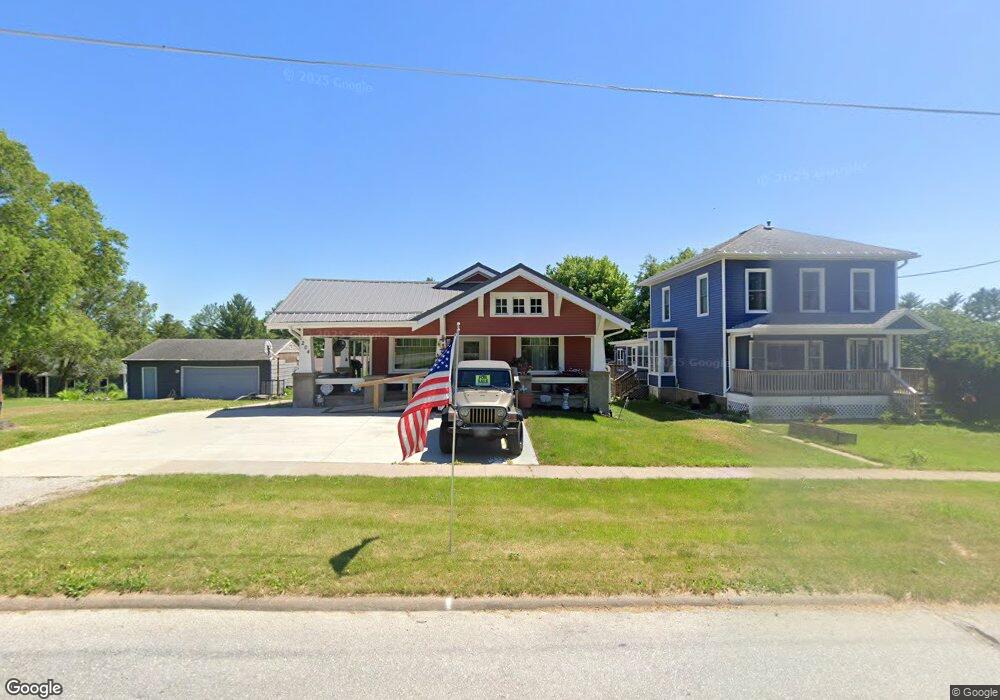
204 Wetherell St West Branch, IA 52358
Estimated Value: $256,000 - $368,000
4
Beds
1
Bath
1,412
Sq Ft
$221/Sq Ft
Est. Value
About This Home
This home is located at 204 Wetherell St, West Branch, IA 52358 and is currently estimated at $312,023, approximately $220 per square foot. 204 Wetherell St is a home with nearby schools including Hoover Elementary School, West Branch Middle School, and West Branch High School.
Ownership History
Date
Name
Owned For
Owner Type
Purchase Details
Closed on
Oct 1, 2021
Sold by
Hollingsworth Duane L
Bought by
Haub Properties Llc
Current Estimated Value
Create a Home Valuation Report for This Property
The Home Valuation Report is an in-depth analysis detailing your home's value as well as a comparison with similar homes in the area
Home Values in the Area
Average Home Value in this Area
Purchase History
| Date | Buyer | Sale Price | Title Company |
|---|---|---|---|
| Haub Properties Llc | $380,000 | Jeremy Bp Hagan Pugh Hagan Pra |
Source: Public Records
Tax History Compared to Growth
Tax History
| Year | Tax Paid | Tax Assessment Tax Assessment Total Assessment is a certain percentage of the fair market value that is determined by local assessors to be the total taxable value of land and additions on the property. | Land | Improvement |
|---|---|---|---|---|
| 2025 | $5,230 | $330,630 | $28,560 | $302,070 |
| 2024 | $5,230 | $318,060 | $28,560 | $289,500 |
| 2023 | $4,910 | $302,950 | $28,560 | $274,390 |
| 2022 | $4,526 | $242,970 | $26,520 | $216,450 |
| 2021 | $4,660 | $242,970 | $26,520 | $216,450 |
| 2020 | $4,510 | $238,890 | $22,440 | $216,450 |
| 2019 | $4,114 | $234,060 | $0 | $0 |
| 2018 | $4,024 | $234,060 | $0 | $0 |
| 2017 | $3,890 | $212,850 | $0 | $0 |
| 2016 | $3,870 | $212,850 | $0 | $0 |
| 2015 | $3,854 | $211,190 | $0 | $0 |
| 2014 | $3,854 | $211,190 | $0 | $0 |
Source: Public Records
Map
Nearby Homes
- 120 N Downey St
- 127 N Downey St
- 316 S Maple St
- 426 N 1st St
- 360 Cookson Dr
- 314 Sycamore Dr
- 312 Sycamore Dr
- 316 Sycamore Dr
- 611 Riley Ln
- 173 Hilltop Dr
- 121 Northridge Dr Unit 121-139
- 609 W Orange St
- 521 N 4th St Unit Louise Court Condos
- 557 N 4th St
- 3 Grant St Unit GR3
- 212 Dawson Dr
- 719 Sullivan St
- Lot 17 Meadows Subdivision Part 5
- 33 Lou Henry Ln Unit AM33
- 35 Lou Henry Ln Unit AM35
- 142 Wetherell St
- 212 Wetherell St
- 204 W Main St
- 208 W Main St
- 222 Wetherell St
- 136 Wetherell St
- Parcel "P" Wetherell St
- 142 W Main St
- 212 W Main St
- 217 Wetherell St
- 136 W Main St
- 226 Wetherell St
- 132 W Main St
- 222 W Main St
- 216 W Main St Unit Parcel "N"
- 221 Wetherell St
- 130 W Main St
- 226 W Main St
- 207 W Main St
- 217 W Main St