
20400 Rock Run Dr Joliet, IL 60431
Southwest Joliet NeighborhoodEstimated payment $4,967/month
Highlights
- Waterfront
- Farm
- Corner Lot
- 20 Acre Lot
- Property is near a park
About This Lot
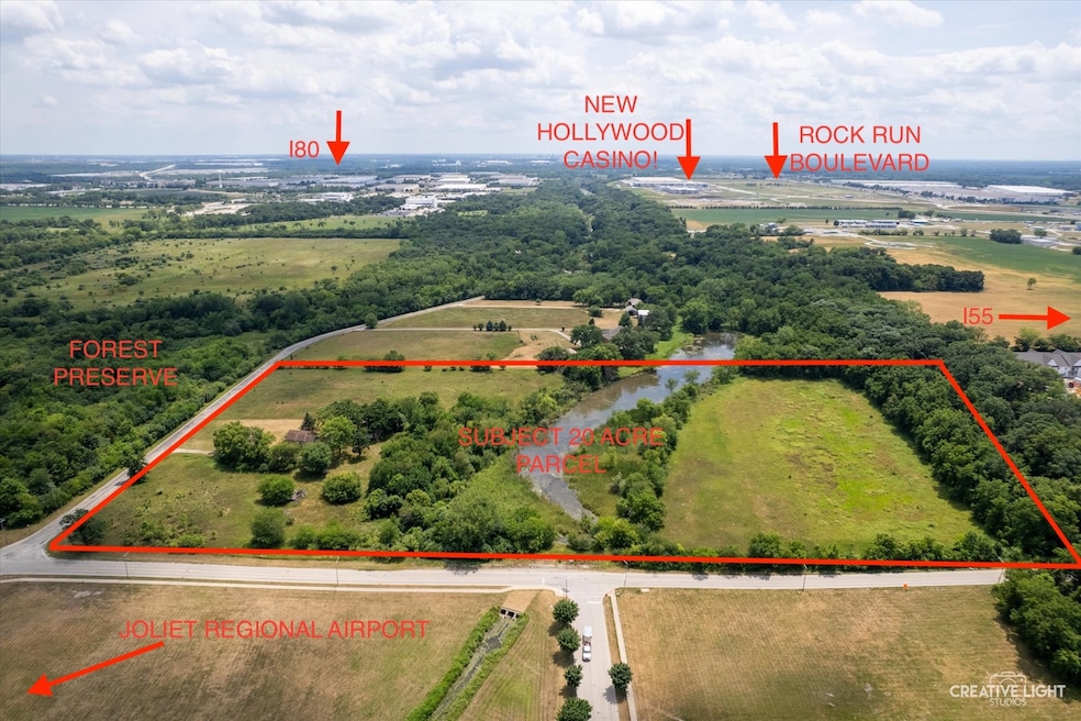
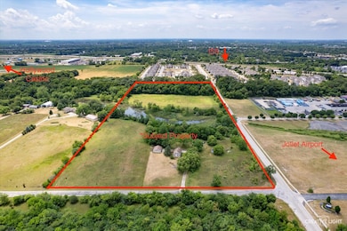
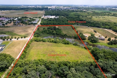
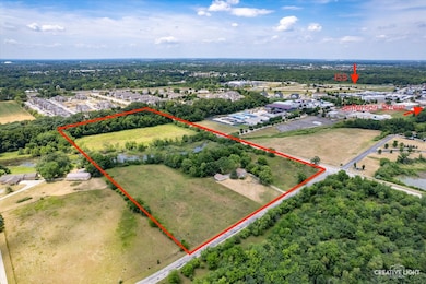
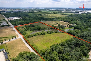
20 ACRES LOCATED IN A GREAT PRIME LOCATION!! THIS PARCEL IS CONVENIENTLY LOCATED BY THE JOLIET REGIONAL AIRPORT AND THE NEWLY OPENED EMPRESS CASINO!!! THIS PARCEL IS ALSO LOCATED RIGHT BY THE NEW ROCK RUN BOULEVARD DEVELOPMENT! ALSO LOCATED WITHIN A CLOSE PROXIMITY TO JOLIET JUNIOR COLLEGE!!! THE 20 ACRE PARCEL IS CURRENTLY ZONED AGRICULTURAL BUT THERE IS INDUSTRIAL ZONING TO THE NORTH ON MCDONALD DRIVE, RESIDENTIAL ON ROCK RUN & MCDONOUGH DRIVE ALONG WITH COMMERCIAL ZOING AS WELL. WITH INCREDIBLE EASY INTERSTATE ACCESS TO 155 AND 180 THE FUTURE DEVELOPMENT POSSIBILITIES ARE ENDLESS! MAYBE RESIDENTIAL? HOTEL? COMMERCIAL/INDUSTRIAL PROJECTS?!! MCDONOUGH ST FRONTAGE - 1300' & 665' OF FRONTAGE ON ROCK RUN DRIVE. ELECTRIC AND CITY OF JOLIET WATER HOOK UP TO SITE MULTIPLE PIN NUMBERS 0506154000100020 (14.09 Acres) & 0506154000100010 (5.86 acres)
Listing Agent
Realty Representatives Inc Brokerage Phone: (815) 263-3666 License #471005175 Listed on: 07/14/2025
Property Details
Property Type
- Land
Est. Annual Taxes
- $3,309
Lot Details
- 20 Acre Lot
- Lot Dimensions are 319x375x355x665x591x349
- Waterfront
- Property fronts an interstate
- Corner Lot
- Additional Parcels
- Property is zoned AGRIC
Home Design
- Mixed Use
Utilities
- Heating System Uses Natural Gas
- Well
- Septic Tank
Additional Features
- Laundry in unit
- Property is near a park
- Farm
Map
Home Values in the Area
Average Home Value in this Area
Tax History
| Year | Tax Paid | Tax Assessment Tax Assessment Total Assessment is a certain percentage of the fair market value that is determined by local assessors to be the total taxable value of land and additions on the property. | Land | Improvement |
|---|---|---|---|---|
| 2024 | $3,510 | $43,713 | $27,253 | $16,460 |
| 2023 | $3,510 | $39,183 | $24,394 | $14,789 |
| 2022 | $3,279 | $36,859 | $22,865 | $13,994 |
| 2021 | $2,905 | $34,482 | $21,317 | $13,165 |
| 2020 | $2,886 | $34,187 | $21,022 | $13,165 |
| 2019 | $2,789 | $32,591 | $19,963 | $12,628 |
| 2018 | $2,846 | $32,350 | $19,722 | $12,628 |
| 2017 | $2,881 | $32,152 | $19,524 | $12,628 |
| 2016 | $2,966 | $31,978 | $19,350 | $12,628 |
| 2015 | $2,638 | $29,722 | $17,094 | $12,628 |
| 2014 | $2,638 | $28,554 | $17,065 | $11,489 |
| 2013 | $2,638 | $28,891 | $17,402 | $11,489 |
Property History
| Date | Event | Price | List to Sale | Price per Sq Ft |
|---|---|---|---|---|
| 09/29/2025 09/29/25 | Price Changed | $890,000 | -4.3% | -- |
| 07/14/2025 07/14/25 | For Sale | $930,000 | -- | -- |
Purchase History
| Date | Type | Sale Price | Title Company |
|---|---|---|---|
| Interfamily Deed Transfer | -- | Accommodation |
Source: Midwest Real Estate Data (MRED)
MLS Number: 12418591
APN: 05-06-15-400-010-0010
Disclaimer: Certain information contained herein is derived from information provided by parties other than Homes.com. All information provided is deemed reliable, but is not guaranteed to be accurate and should be independently verified.
![]() Based on information submitted to the MLS GRID. All data is obtained from various sources and may not have been verified by broker or MLS GRID. Supplied Open House Information is subject to change without notice. All information should be independently reviewed and verified for accuracy. Properties may or may not be listed by the office/agent presenting the information. Some IDX listings have been excluded from this website.
Based on information submitted to the MLS GRID. All data is obtained from various sources and may not have been verified by broker or MLS GRID. Supplied Open House Information is subject to change without notice. All information should be independently reviewed and verified for accuracy. Properties may or may not be listed by the office/agent presenting the information. Some IDX listings have been excluded from this website.
The Digital Millennium Copyright Act of 1998, 17 U.S.C. § 512 (the “DMCA”) provides recourse for copyright owners who believe that material appearing on the Internet infringes their rights under U.S. copyright law. If you believe in good faith that any content or material made available in connection with our website or services infringes your copyright, you (or your agent) may send us a notice requesting that the content or material be removed, or access to it blocked.
Notices must be sent in writing by email to DMCAnotice@MLSGrid.com.
The DMCA requires that your notice of alleged copyright infringement include the following information:
(1) description of the copyrighted work that is the subject of claimed infringement;
(2) description of the alleged infringing content and information sufficient to permit us to locate the content;
(3) contact information for you, including your address, telephone number and email address;
(4) a statement by you that you have a good faith belief that the content in the manner complained of is not authorized by the copyright owner, or its agent, or by the operation of any law;
(5) a statement by you, signed under penalty of perjury, that the information in the notification is accurate and that you have the authority to enforce the copyrights that are claimed to be infringed; and
(6) a physical or electronic signature of the copyright owner or a person authorized to act on the copyright owner’s behalf. Failure to include all of the above information may result in the delay of the processing of your complaint.
- 4319 Timber Ridge Ct
- 4313 Timber Ridge Ct
- 4208 Whitetail Ct
- 201 Oakwood Dr
- 737 Springwood Dr
- 743 Springwood Dr
- 200 Shorewood Ln
- 615 Silver Leaf Dr
- 111 Dupage St
- 710 Silver Leaf Ct Unit 1
- 709 Winterberry Dr
- 206 Stephen Ln
- 741 River Bluff Dr
- 20718 S Sarver Dr Unit 1
- 202 Oak Dr
- 645 Berry Ridge Dr
- 20937 S Ron Lee Dr
- 985 Leawood Dr
- 1007 Windsor Dr
- 3219 Quincy Ct
- 510 Timber Pointe Dr
- 3616 Forest View Dr Unit 3616
- 3610 Forestview Dr
- 125 Twin Oaks Dr
- 125 Twin Oaks Dr
- 125 Twin Oaks Dr
- 125 Twin Oaks Dr Unit 319
- 1113 Geneva St
- 109 Ravinia Dr
- 23209 W Mound Rd
- 1304 Partridge Dr
- 4932 Montauk Dr
- 5130 Freeport Dr Unit 6
- 5111 Freeport Ct
- 1300 Broadlawn Dr
- 509 Kungs Way Unit 2N
- 5309 Pine Trails Cir
- 1400 Bridgehampton Dr
- 2355 White Birch Ln
- 1258 Lasser Dr
