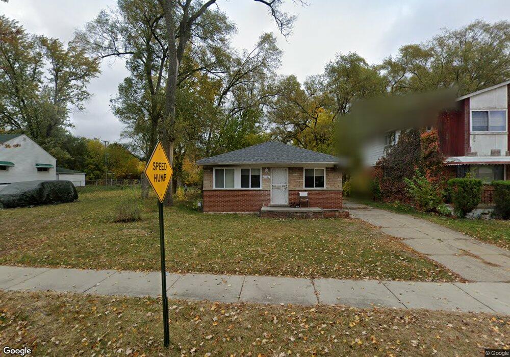
20446 Prairie St Unit Bldg-Unit Detroit, MI 48221
Garden Homes NeighborhoodEstimated Value: $97,000 - $126,107
--
Bed
1
Bath
1,018
Sq Ft
$110/Sq Ft
Est. Value
About This Home
This home is located at 20446 Prairie St Unit Bldg-Unit, Detroit, MI 48221 and is currently estimated at $111,527, approximately $109 per square foot. 20446 Prairie St Unit Bldg-Unit is a home located in Wayne County with nearby schools including Pasteur Elementary School, Charles L. Spain Elementary-Middle School, and Edward 'Duke' Ellington Conservatory of Music and Art.
Ownership History
Date
Name
Owned For
Owner Type
Purchase Details
Closed on
Aug 2, 2018
Sold by
Realty Detroit Properties Two Llc
Bought by
Ourhomes Llc
Current Estimated Value
Purchase Details
Closed on
Oct 20, 2017
Sold by
Realty Transition Llc
Bought by
Realty Detroit Properties Two Llc
Purchase Details
Closed on
Sep 1, 2017
Sold by
Wayne County Land Bank Corporation
Bought by
Realty Transition Llc
Purchase Details
Closed on
Aug 30, 2017
Sold by
Public Body Corporate
Bought by
Wayne County Land Bank Corporation
Purchase Details
Closed on
Aug 29, 2017
Sold by
Sabree Eric R
Bought by
County Of Wayne
Purchase Details
Closed on
Jun 1, 2013
Sold by
Manning Edwards Sandra
Bought by
Edwards Jevon
Purchase Details
Closed on
Sep 28, 2012
Sold by
Manning Leo
Bought by
Manning Edwards Sandra
Create a Home Valuation Report for This Property
The Home Valuation Report is an in-depth analysis detailing your home's value as well as a comparison with similar homes in the area
Home Values in the Area
Average Home Value in this Area
Purchase History
| Date | Buyer | Sale Price | Title Company |
|---|---|---|---|
| Ourhomes Llc | $90,000 | Michigan Title Ins Agency | |
| Realty Detroit Properties Two Llc | -- | None Available | |
| Realty Transition Llc | $304,983 | None Available | |
| Wayne County Land Bank Corporation | -- | None Available | |
| County Of Wayne | $9,306 | None Available | |
| Edwards Jevon | -- | None Available | |
| Manning Edwards Sandra | -- | None Available |
Source: Public Records
Tax History Compared to Growth
Tax History
| Year | Tax Paid | Tax Assessment Tax Assessment Total Assessment is a certain percentage of the fair market value that is determined by local assessors to be the total taxable value of land and additions on the property. | Land | Improvement |
|---|---|---|---|---|
| 2025 | $1,403 | $37,700 | $0 | $0 |
| 2024 | $1,403 | $31,800 | $0 | $0 |
| 2023 | $1,362 | $24,800 | $0 | $0 |
| 2022 | $1,453 | $21,900 | $0 | $0 |
| 2021 | $1,413 | $16,900 | $0 | $0 |
| 2020 | $1,432 | $16,600 | $0 | $0 |
| 2019 | $1,391 | $13,600 | $0 | $0 |
| 2018 | $1,218 | $12,700 | $0 | $0 |
| 2017 | $195 | $12,200 | $0 | $0 |
| 2016 | $1,147 | $22,100 | $0 | $0 |
| 2015 | $1,200 | $12,000 | $0 | $0 |
| 2013 | $1,335 | $16,916 | $0 | $0 |
| 2010 | -- | $22,433 | $698 | $21,735 |
Source: Public Records
Map
Nearby Homes
- 20235 Prairie St
- 20401 Santa Rosa Dr
- 20235 San Juan Dr
- 20174 San Juan Dr
- 20200 Woodingham Dr
- 20145 Santa Barbara Dr
- 20038 Santa Rosa Dr
- 20115 Santa Barbara Dr
- 19994 Santa Rosa Dr
- 19980 Stoepel St
- 20441 Gardendale St
- 19977 Santa Barbara Dr
- 20179 Canterbury Rd
- 20045 Greenlawn St
- 20073 Shrewsbury Rd
- 591 Parkside Way Unit 16
- 19786 Pennington Dr
- 20111 Roselawn St
- 19758 Prairie St
- 19965 Greenlawn St
- 20446 Prairie St
- 20440 Prairie St
- 20460 Prairie St
- 20432 Prairie St
- 20470 Prairie St
- 20418 Prairie St
- 20447 Monica St
- 20453 Monica St
- 20465 Monica St
- 20480 Prairie St
- 20455 Prairie St
- 20429 Monica St
- 20412 Prairie St
- 20471 Monica St
- 20488 Prairie St
- 20447 Prairie St
- 20477 Monica St
- 20425 Prairie St
- 20417 Monica St
- 20400 Prairie St