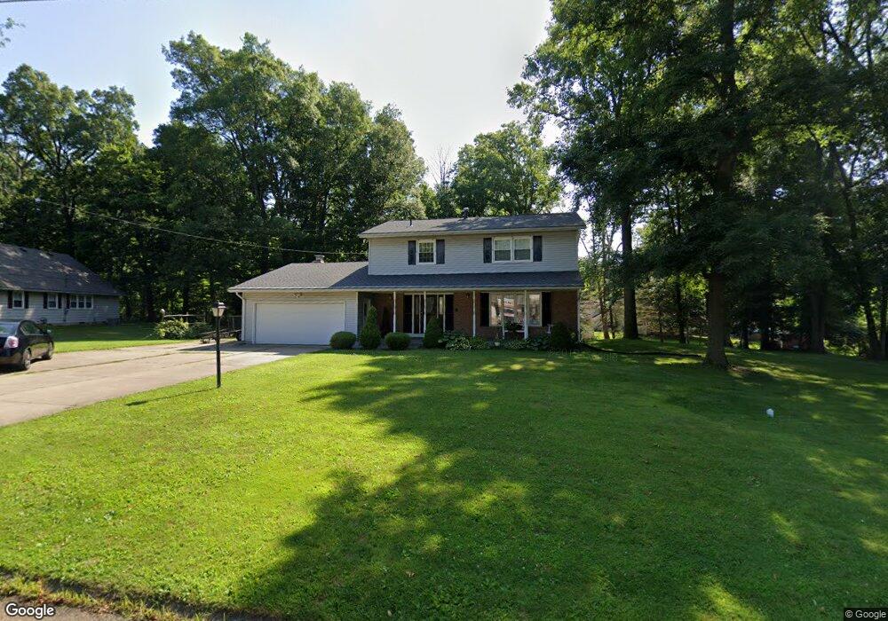
2045 Random Dr Mansfield, OH 44904
Estimated Value: $282,815 - $297,000
3
Beds
3
Baths
2,212
Sq Ft
$130/Sq Ft
Est. Value
About This Home
This home is located at 2045 Random Dr, Mansfield, OH 44904 and is currently estimated at $287,454, approximately $129 per square foot. 2045 Random Dr is a home located in Richland County with nearby schools including Lexington High School, Mansfield Christian School, and Mansfield Seventh-day Adventist School.
Ownership History
Date
Name
Owned For
Owner Type
Purchase Details
Closed on
Nov 2, 2009
Sold by
Berk Robert L and Berk Mary L
Bought by
Fontes Jordan L
Current Estimated Value
Home Financials for this Owner
Home Financials are based on the most recent Mortgage that was taken out on this home.
Original Mortgage
$135,990
Outstanding Balance
$86,749
Interest Rate
5.11%
Mortgage Type
FHA
Estimated Equity
$200,705
Purchase Details
Closed on
Jul 23, 2002
Sold by
Trst Richard Doklovic
Bought by
Berk Robert L and Berk Mary L
Home Financials for this Owner
Home Financials are based on the most recent Mortgage that was taken out on this home.
Original Mortgage
$116,000
Interest Rate
6.79%
Mortgage Type
New Conventional
Create a Home Valuation Report for This Property
The Home Valuation Report is an in-depth analysis detailing your home's value as well as a comparison with similar homes in the area
Home Values in the Area
Average Home Value in this Area
Purchase History
| Date | Buyer | Sale Price | Title Company |
|---|---|---|---|
| Fontes Jordan L | $138,500 | Southern Title | |
| Berk Robert L | $145,000 | -- |
Source: Public Records
Mortgage History
| Date | Status | Borrower | Loan Amount |
|---|---|---|---|
| Open | Fontes Jordan L | $135,990 | |
| Previous Owner | Berk Robert L | $116,000 |
Source: Public Records
Tax History
| Year | Tax Paid | Tax Assessment Tax Assessment Total Assessment is a certain percentage of the fair market value that is determined by local assessors to be the total taxable value of land and additions on the property. | Land | Improvement |
|---|---|---|---|---|
| 2025 | $3,775 | $72,840 | $9,660 | $63,180 |
| 2024 | $3,775 | $72,840 | $9,660 | $63,180 |
| 2023 | $3,859 | $72,840 | $9,660 | $63,180 |
| 2022 | $3,457 | $54,970 | $8,290 | $46,680 |
| 2021 | $3,506 | $54,970 | $8,290 | $46,680 |
| 2020 | $3,327 | $54,970 | $8,290 | $46,680 |
| 2019 | $3,041 | $46,080 | $6,950 | $39,130 |
| 2018 | $2,616 | $46,080 | $6,950 | $39,130 |
| 2017 | $2,517 | $46,080 | $6,950 | $39,130 |
| 2016 | $2,446 | $42,450 | $5,920 | $36,530 |
| 2015 | $2,359 | $42,450 | $5,920 | $36,530 |
| 2014 | $2,359 | $42,450 | $5,920 | $36,530 |
| 2012 | $1,149 | $43,760 | $6,100 | $37,660 |
Source: Public Records
Map
Nearby Homes
- 633 Princeton Ct
- 515 W Hanley Rd
- 1938 Richwood Dr
- 2226 Camden Ct
- 615 Bailey Dr
- 635 Karlson Dr
- 1759 Rocky Rill Ct
- 763 York St W
- 1702 Middle Bellville Rd
- 0 Rippling Brook Dr
- 213 Brushwood Dr
- 872 Red Oak Trail Unit 3
- 893 Greenfield Dr
- 1599 S Main St
- 0 Lot #23132 Hess Cir
- 0 Lot #23127 Hess Cir
- 0 Lot #23139 Hess Cir
- 0 Lot #23121 Hess Cir
- 0 Lot #23133 Hess Cir
- 50 Lilac Ct E
- 420 Walfield Dr
- 2055 Random St
- 2044 Random Dr
- 2050 Ranchwood Dr
- 2056 Random Dr
- 426 Walfield Dr
- 1964 Ranchwood Dr
- 441 Walfield Dr
- 432 Walfield Dr
- 2075 Random Dr
- 568 Orchard Dr E
- 1980 Ranchwood Dr
- 2074 Random Dr
- 457 Walfield Dr
- 438 Walfield Dr
- 578 Orchard Dr E
- 1947 Ranchwood Dr
- 450 Walfield Dr
- 2084 Random Dr
- 1988 Ranchwood Dr
Your Personal Tour Guide
Ask me questions while you tour the home.