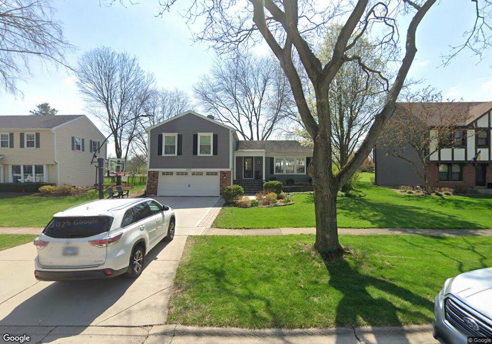
2048 Dorset Dr Unit 7 Wheaton, IL 60189
Stonehedge NeighborhoodEstimated Value: $542,465 - $711,000
4
Beds
3
Baths
1,652
Sq Ft
$370/Sq Ft
Est. Value
About This Home
This home is located at 2048 Dorset Dr Unit 7, Wheaton, IL 60189 and is currently estimated at $610,866, approximately $369 per square foot. 2048 Dorset Dr Unit 7 is a home located in DuPage County with nearby schools including Whittier Elementary School, Edison Middle School, and Wheaton Warrenville South High School.
Ownership History
Date
Name
Owned For
Owner Type
Purchase Details
Closed on
Mar 10, 2015
Sold by
Syre Robert D
Bought by
Aurich Robert H and Aurich Megan M
Current Estimated Value
Purchase Details
Closed on
Jan 28, 2011
Sold by
Jenkin Anthony D M and Jenkin Lisa Marie
Bought by
Aurich Robert H and Syre Robert D
Home Financials for this Owner
Home Financials are based on the most recent Mortgage that was taken out on this home.
Original Mortgage
$311,888
Interest Rate
4.75%
Mortgage Type
FHA
Purchase Details
Closed on
Jul 11, 1997
Sold by
Turner Ned R
Bought by
Jenkin Anthony Dm and Jenkin Lisa Marie
Home Financials for this Owner
Home Financials are based on the most recent Mortgage that was taken out on this home.
Original Mortgage
$185,600
Interest Rate
7.81%
Mortgage Type
Balloon
Create a Home Valuation Report for This Property
The Home Valuation Report is an in-depth analysis detailing your home's value as well as a comparison with similar homes in the area
Home Values in the Area
Average Home Value in this Area
Purchase History
| Date | Buyer | Sale Price | Title Company |
|---|---|---|---|
| Aurich Robert H | -- | Attorneys Title Guaranty Fun | |
| Aurich Robert H | $320,000 | Atg | |
| Jenkin Anthony Dm | $232,000 | First American Title |
Source: Public Records
Mortgage History
| Date | Status | Borrower | Loan Amount |
|---|---|---|---|
| Previous Owner | Aurich Robert H | $311,888 | |
| Previous Owner | Jenkin Anthony Dm | $185,600 |
Source: Public Records
Tax History
| Year | Tax Paid | Tax Assessment Tax Assessment Total Assessment is a certain percentage of the fair market value that is determined by local assessors to be the total taxable value of land and additions on the property. | Land | Improvement |
|---|---|---|---|---|
| 2024 | $9,653 | $166,741 | $51,778 | $114,963 |
| 2023 | $9,274 | $153,480 | $47,660 | $105,820 |
| 2022 | $9,090 | $137,260 | $45,040 | $92,220 |
| 2021 | $9,059 | $134,000 | $43,970 | $90,030 |
| 2020 | $9,031 | $132,750 | $43,560 | $89,190 |
| 2019 | $8,824 | $129,250 | $42,410 | $86,840 |
| 2018 | $7,944 | $115,680 | $39,960 | $75,720 |
| 2017 | $7,824 | $111,420 | $38,490 | $72,930 |
| 2016 | $7,717 | $106,970 | $36,950 | $70,020 |
| 2015 | $7,655 | $102,050 | $35,250 | $66,800 |
| 2014 | $7,452 | $97,910 | $34,740 | $63,170 |
| 2013 | $7,260 | $98,200 | $34,840 | $63,360 |
Source: Public Records
Map
Nearby Homes
- 25W773 Sunnyridge Ct
- 2S671 Arrowhead Dr
- 2631 Weatherbee Ln
- 141 Loretto Ct
- 1127 Hibbard Rd
- 30 Danada Dr
- 1605 Burning Trail
- 1601 W Wiesbrook Rd
- 1612 Stonebridge Trail
- 1519 Foothill Dr
- 2110 Weatherbee Ln
- Lot 1 Foothill Dr
- 2099 Creekside Dr Unit 1-4
- 2127 Iron Ridge Ln
- 2034 Iron Ridge Ln
- 2114 Iron Ridge Ln
- 2116 Iron Ridge Ln
- 2128 Iron Ridge Ln
- 2038 Iron Ridge Ln
- 1028 Lodalia Ct
- 2042 Dorset Dr
- 2060 Dorset Dr
- 2036 Dorset Dr
- 2053 Dorset Dr
- 2047 Dorset Dr
- 2057 Dorset Dr
- 2039 Dorset Dr
- 2066 Dorset Dr
- 2030 Dorset Dr
- 2054 Sherwood Place
- 2033 Dorset Dr
- 2018 Berkshire Place
- 2024 Dorset Dr
- 2046 Sherwood Place
- 2024 Berkshire Place
- 1186 Dorset Dr
- 2014 Berkshire Place
- 2025 Dorset Dr
- 2038 Sherwood Place
- 2018 Dorset Dr
Your Personal Tour Guide
Ask me questions while you tour the home.