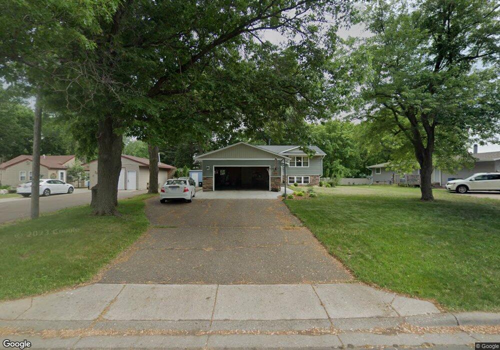
2048 Stowe Ave New Brighton, MN 55112
Estimated Value: $366,000 - $1,966,631
4
Beds
2
Baths
680
Sq Ft
$1,138/Sq Ft
Est. Value
About This Home
This home is located at 2048 Stowe Ave, New Brighton, MN 55112 and is currently estimated at $774,158, approximately $1,138 per square foot. 2048 Stowe Ave is a home located in Ramsey County with nearby schools including Valentine Hills Elementary School, Highview Middle School, and Mounds View Senior High School.
Ownership History
Date
Name
Owned For
Owner Type
Purchase Details
Closed on
Mar 29, 2017
Sold by
Dwelly Michael L and Dwelly Beverly J
Bought by
Larson Ryan C and Larson Jennifer K
Current Estimated Value
Home Financials for this Owner
Home Financials are based on the most recent Mortgage that was taken out on this home.
Original Mortgage
$186,678
Outstanding Balance
$155,131
Interest Rate
4.16%
Estimated Equity
$619,027
Create a Home Valuation Report for This Property
The Home Valuation Report is an in-depth analysis detailing your home's value as well as a comparison with similar homes in the area
Home Values in the Area
Average Home Value in this Area
Purchase History
| Date | Buyer | Sale Price | Title Company |
|---|---|---|---|
| Larson Ryan C | $1,318,418 | North American Title Co |
Source: Public Records
Mortgage History
| Date | Status | Borrower | Loan Amount |
|---|---|---|---|
| Open | Larson Ryan C | $186,678 |
Source: Public Records
Tax History Compared to Growth
Tax History
| Year | Tax Paid | Tax Assessment Tax Assessment Total Assessment is a certain percentage of the fair market value that is determined by local assessors to be the total taxable value of land and additions on the property. | Land | Improvement |
|---|---|---|---|---|
| 2025 | $3,738 | $356,600 | $91,400 | $265,200 |
| 2023 | $3,738 | $314,000 | $91,400 | $222,600 |
| 2022 | $3,312 | $302,200 | $91,400 | $210,800 |
| 2021 | $3,228 | $255,000 | $91,400 | $163,600 |
| 2020 | $3,478 | $255,600 | $91,400 | $164,200 |
| 2019 | $3,048 | $255,400 | $91,400 | $164,000 |
| 2018 | $2,944 | $240,800 | $91,400 | $149,400 |
| 2017 | $2,848 | $227,300 | $91,400 | $135,900 |
| 2016 | $2,898 | $0 | $0 | $0 |
| 2015 | $2,718 | $214,500 | $91,400 | $123,100 |
| 2014 | $2,304 | $0 | $0 | $0 |
Source: Public Records
Map
Nearby Homes
- 1999 Edgewater Ave
- 2 New Brighton Rd
- 4 New Brighton Rd
- 1960 Glenpaul Ave
- 1932 Glenpaul Ave
- 3 New Brighton Rd
- 1 New Brighton Rd
- 950 Cessna Dr
- 519 Continental Dr
- 3072 Fairview Ave N
- 737 Mccallum Dr
- 1802 Lydia Ave W
- 2452 County Road D W
- 2446 County Road D W
- 1688 Chatham Ave
- 509 4th Ave NW
- 228 16th Ave SW
- 3912 Foss Rd Unit 206
- 3915 Foss Rd Unit 102
- 4074 Foss Rd
- 2040 Stowe Ave
- 2056 Stowe Ave
- 2040 2040 Stowe Ave
- 2034 Stowe Ave
- 2034 2034 Stowe Ave
- 3333 Katie Ln
- XXXX Katie Ln
- 3331 Katie Ln
- 3335 Katie Ln
- 397 Cleveland Ave SW
- 398 1st Ave SE
- 2026 2026 Stowe Ave
- 2026 Stowe Ave
- 3329 Katie Ln
- 2020 Stowe Ave
- 383 Cleveland Ave SW
- 386 1st Ave SE
- 102 Stowe Ave
- 3327 Katie Ln
- 3330 Katie Ln