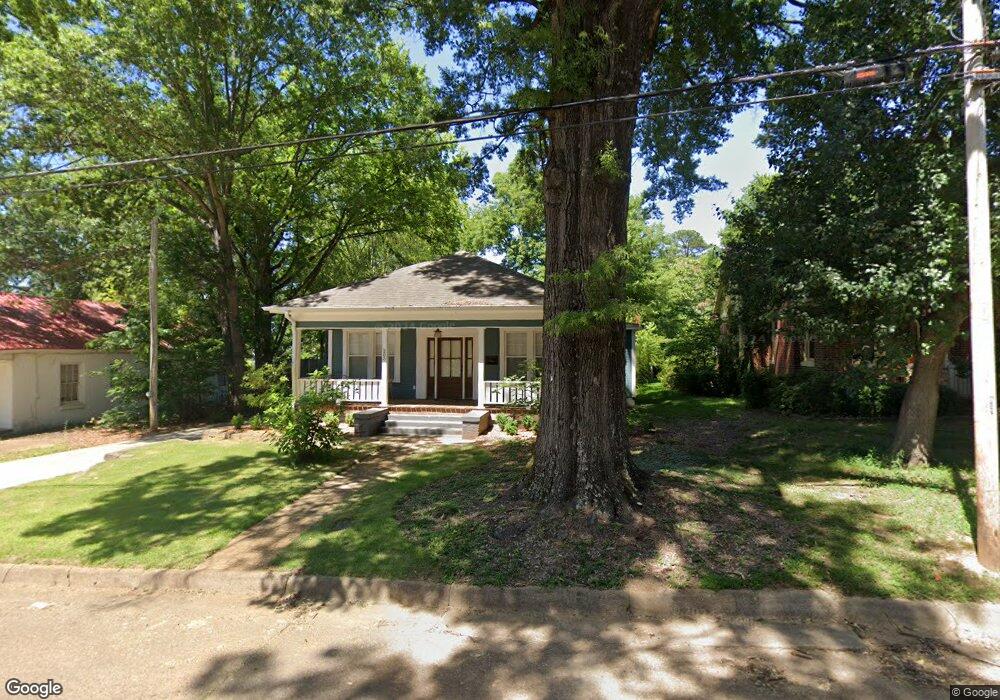
205 Oak St New Albany, MI 38652
Estimated Value: $173,942 - $238,000
4
Beds
2
Baths
1,547
Sq Ft
$135/Sq Ft
Est. Value
About This Home
This home is located at 205 Oak St, New Albany, MI 38652 and is currently estimated at $208,736, approximately $134 per square foot. 205 Oak St is a home located in Union County with nearby schools including New Albany Elementary School, New Albany/S.Tippah/Union County Alternative School, and New Albany Middle School.
Ownership History
Date
Name
Owned For
Owner Type
Purchase Details
Closed on
May 29, 2018
Sold by
Youree Susan
Bought by
Walker Hanson
Current Estimated Value
Home Financials for this Owner
Home Financials are based on the most recent Mortgage that was taken out on this home.
Original Mortgage
$135,009
Outstanding Balance
$116,760
Interest Rate
4.5%
Mortgage Type
Unknown
Estimated Equity
$91,976
Purchase Details
Closed on
Nov 9, 2017
Sold by
Thompson Amos G and Thompson Lee A
Bought by
Youree Susan
Home Financials for this Owner
Home Financials are based on the most recent Mortgage that was taken out on this home.
Original Mortgage
$131,575
Interest Rate
3.91%
Mortgage Type
New Conventional
Purchase Details
Closed on
Mar 6, 2008
Sold by
Haynie Mary Ann and Haynie Steven M
Bought by
Haynie Mary Ann
Create a Home Valuation Report for This Property
The Home Valuation Report is an in-depth analysis detailing your home's value as well as a comparison with similar homes in the area
Home Values in the Area
Average Home Value in this Area
Purchase History
| Date | Buyer | Sale Price | Title Company |
|---|---|---|---|
| Walker Hanson | -- | None Available | |
| Youree Susan | -- | None Available | |
| Haynie Mary Ann | -- | -- |
Source: Public Records
Mortgage History
| Date | Status | Borrower | Loan Amount |
|---|---|---|---|
| Open | Walker Hanson | $135,009 | |
| Previous Owner | Youree Susan | $131,575 |
Source: Public Records
Tax History Compared to Growth
Tax History
| Year | Tax Paid | Tax Assessment Tax Assessment Total Assessment is a certain percentage of the fair market value that is determined by local assessors to be the total taxable value of land and additions on the property. | Land | Improvement |
|---|---|---|---|---|
| 2024 | $923 | $8,541 | $0 | $0 |
| 2023 | $926 | $8,541 | $0 | $0 |
| 2022 | $703 | $6,795 | $0 | $0 |
| 2021 | $330 | $3,341 | $0 | $0 |
| 2020 | $330 | $3,341 | $0 | $0 |
| 2019 | $330 | $3,341 | $0 | $0 |
| 2018 | $444 | $3,168 | $0 | $0 |
| 2017 | $299 | $3,168 | $0 | $0 |
| 2016 | $285 | $3,168 | $0 | $0 |
| 2015 | -- | $4,752 | $0 | $0 |
| 2014 | -- | $4,107 | $0 | $0 |
Source: Public Records
Map
Nearby Homes
- 211 E Main St
- 613 Ramble Ln
- 111 Cleveland St
- 1387 Cr 81
- 1088
- 504 Hobson St
- 0 Mississippi 178
- 313 Garfield St
- 203 Alabama St
- 400 Alabama St
- 810 Brookwood St
- 409 Broad St
- 804 Idlewild Cr
- 0 North St
- 0 Bratton Rd Unit 23-3891
- 828 Brookwood St
- 910 S Central Ave
- Lot 102 Greenhaven Dr
- Lot 92 Greenhaven Dr
- Lot 100 Greenhaven Dr